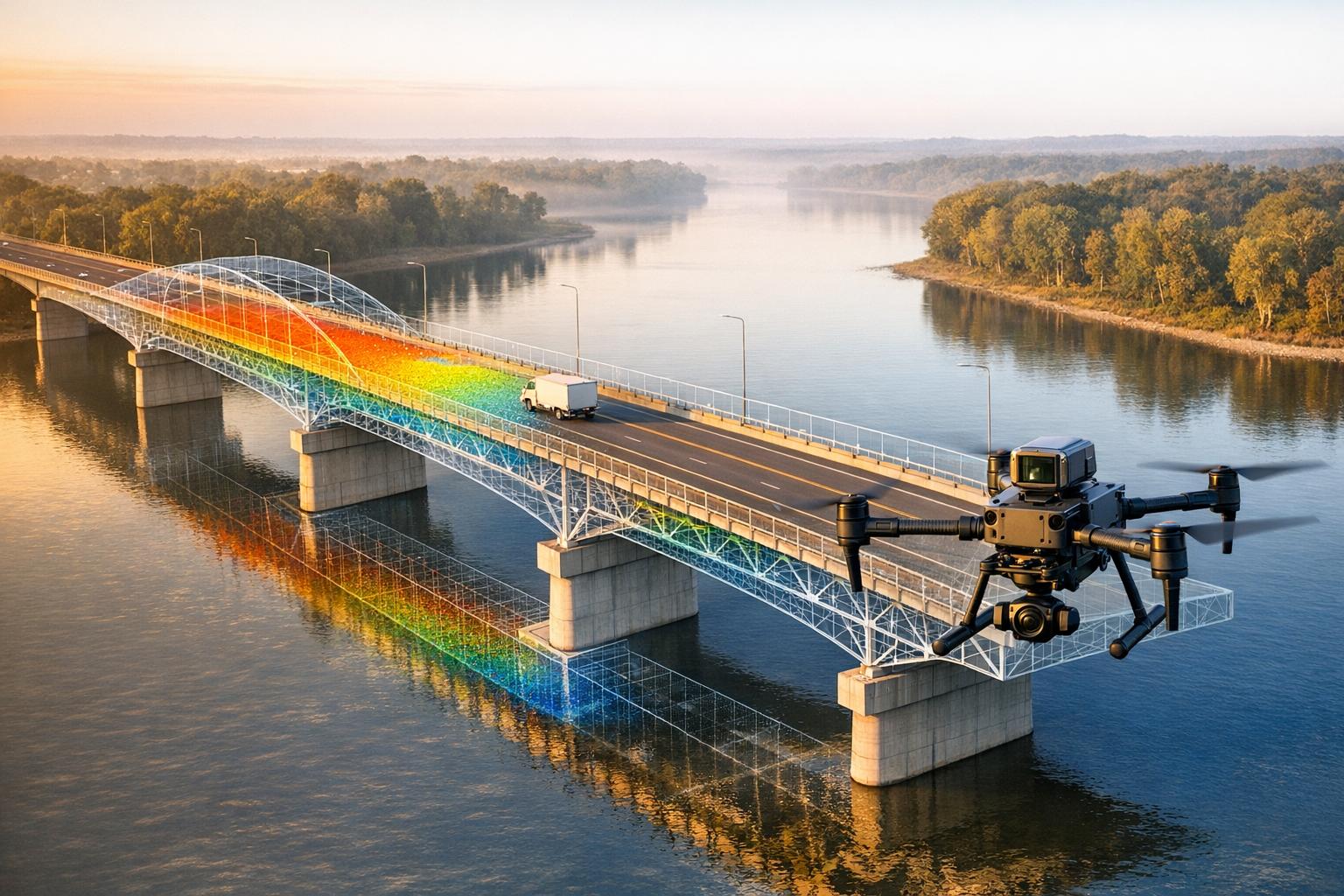
Drones are transforming how bridges are inspected. They offer safer, faster, and more precise methods compared to older approaches that rely on scaffolding or under-bridge trucks. A 2023 study on Colombia's Río Claro Bridge demonstrated this shift. Drones captured high-resolution images in just one hour, producing 3D models with sub-centimeter accuracy. These models helped engineers detect unseen structural issues and calculate load ratings, confirming the bridge could no longer safely support its intended loads.
Key Takeaways:
- Safety: Drones eliminate risks tied to climbing or working near traffic.
- Efficiency: Inspections are completed in less time, reducing costs by up to 50%.
- Precision: UAVs provide detailed 3D models, enabling accurate damage assessments.
By combining drone data with structural analysis tools, engineers can make informed decisions, ensuring public safety and reducing maintenance costs. However, challenges like wind sensitivity and GPS signal loss under bridges still need addressing.
Data Collection Using UAVs
UAV Flight Planning and Execution
Careful planning is the backbone of creating accurate 3D models for analyzing load-bearing capacity. Engineers need to pinpoint the exact purpose of their inspection - whether it’s spotting tiny cracks or conducting a broader structural review - before choosing the right equipment and mapping out flight paths.
A key part of planning involves calculating the Ground Sampling Distance (GSD) to set the appropriate altitude and camera angles. For the Río Claro Bridge inspection, the team ensured a 75% image overlap, far surpassing the 50% minimum, to boost the accuracy of their 3D models.
Before diving into the main data collection, it’s smart to conduct a reconnaissance flight. This step helps identify structural heights, potential collision hazards like power lines, and areas where GPS signals might drop. For the Río Claro project, the team carried out five free-flight missions over the course of an hour, using four batteries. Free-flight mode allowed pilots to manually navigate the bridge’s intricate geometry, while automated grid patterns worked well for smoother surfaces like the deck soffits.
Weather and environmental conditions can make or break a flight. Wind speeds over 16 mph can destabilize smaller drones, especially near bridge structures where vortex shedding creates turbulence. Magnetic interference from metal elements like guardrails and trusses can also throw off compass readings, making it essential to launch drones from a safe distance and recalibrate frequently. Underneath bridge decks, where GPS signals often fail, pilots must rely entirely on manual controls and obstacle avoidance systems.
By focusing on thorough planning and execution, teams can capture high-quality data, setting the stage for selecting the best sensors and equipment for detailed inspections.
Sensors and Equipment Used
Visual inspections still rely heavily on optical cameras, but the type of lens used can significantly affect results. Standard lenses need to be within 10 feet to spot cracks as small as 0.012 inches in reinforced concrete. On the other hand, zoom lenses can detect the same level of detail from up to 30 feet away, providing a safer option for inspecting hard-to-reach spots like stay cables.
For detecting subsurface issues, thermal and infrared sensors come into play. These tools can identify temperature changes that signal problems like delamination or voids in concrete. Meanwhile, LiDAR systems are indispensable for creating detailed 3D point clouds, which are essential for volumetric measurements. In the Río Claro project, the team paired their camera with RTK GPS positioning and used three physical ground control points to enhance spatial accuracy.
A dual-operator setup is often the go-to approach for these inspections. One operator focuses on piloting the drone safely, while the other adjusts camera settings, exposure, and zoom. This division of responsibilities is particularly useful in complex environments, such as navigating tight spaces between girders. Larger drones tend to handle wind better, offering more stability but requiring greater standoff distances. Conversely, smaller drones excel in confined areas but are more sensitive to gusty winds.
Processing UAV Data for 3D Modeling
Photogrammetry and Point Cloud Generation
Once images are captured, the real work begins: transforming those raw images into a precise 3D model. This is done using advanced techniques like Structure-from-Motion (SfM) and Multi-View Stereo (MVS). These algorithms analyze overlapping images to reconstruct the surface geometry with impressive sub-pixel accuracy.
Specialized software such as Agisoft Metashape, ContextCapture, and Pix4D handles this process in three key steps. First, a sparse point cloud is created by identifying shared features - called tie points - across multiple images. For example, the initial alignment of the Río Claro Bridge produced nearly 57,000 tie points from 536 photographs. Next, the software generates a dense point cloud with much greater detail. Finally, it wraps this point cloud in a 3D mesh and applies texture mapping to replicate the bridge's actual appearance.
The level of detail achieved through UAV photogrammetry is remarkable. At a flight altitude of 98 feet using a 100-megapixel camera, a ground sampling distance (GSD) of 0.05 inches was achieved. In another study, monitoring the Concerto Research Bridge in August 2025, researchers obtained sub-millimeter accuracy when comparing results to physical displacement transducers. This precision is detailed enough to identify hairline cracks and subtle structural deformations.
Once the 3D mesh is complete, the next step is to anchor it to real-world coordinates for meaningful analysis.
Georeferencing and As-Built Bridge Information Modeling (AB-BrIM)
To make the 3D model useful for structural analysis, it must be georeferenced - aligned with real-world geographic positions. This ensures that measurements within the model accurately reflect the bridge's physical dimensions.
There are two main methods for georeferencing. The first is direct georeferencing, where onboard RTK-GNSS receivers record precise coordinates for each photo during the drone's flight. The second method, indirect georeferencing, relies on Ground Control Points (GCPs) - physical markers placed around the bridge and measured with high-precision equipment like total stations. For the Río Claro project, a combination of RTK GPS data and three GCPs was used, resulting in spatial errors as low as 0 to 0.02 feet.
"Employing the introduced UAV-based monitoring approach, a full area-wide quantification of deformation is possible in contrast to classical point or profile measurements."
- Journal of Civil Structural Health Monitoring
Once georeferenced, the 3D model becomes a powerful tool for structural analysis. Engineers can use it as the foundation for As-Built Bridge Information Modeling (AB-BrIM). By importing this detailed geometry into software like CSIbridge, they can calculate load ratings and assess damage. For example, at the Villena Rey Bridge in Lima, Peru, researchers in January 2025 applied binary segmentation techniques - such as converting images to grayscale and using OTSU thresholding - to highlight cracks. This data was then analyzed using a Convolutional Neural Network, achieving an accuracy of 88.4% in automated damage detection and identifying 18 damage points concentrated on the southern pillars.
Load-Bearing Capacity Analysis
Damage Detection and Defect Quantification
Once georeferencing is complete, engineers move on to identifying and measuring structural damage. The process kicks off with binary segmentation, which involves converting images to grayscale and using OTSU thresholding to isolate cracks. These processed images are then analyzed by Convolutional Neural Networks (CNNs), which excel at detecting and labeling cracks with impressive precision.
In January 2025, researchers in Lima, Peru, applied this approach to the Villena Rey Bridge, a reinforced concrete arch bridge built in 1967. Using an EVO II Pro drone combined with a CNN, they identified 18 damage points with an accuracy of 88.4%. Even cracks as narrow as 0.4 mm (about 0.016 inches) were detected from distances of 6.5 to 10 feet.
"When the width of the crack is greater than 0.4 mm, there is already a high level of impact, which indicates a reduction in the earthquake-resistant capacity." - Alfaro et al., Researchers
The identified defects are then mapped onto a 3D photogrammetric model, which highlights areas where damage is concentrated. For example, the left southern pillar of the Villena Rey Bridge was found to have significant damage. Engineers use pixel-based measurements to quantify these defects, determining crack lengths, thicknesses, and rust-stain areas. This method has shown remarkable accuracy, with deviations of just 3.5% for crack length, 7.9% for thickness, and 14.9% for rust stain areas when compared to traditional field measurements. These precise measurements are critical for assessing the structure's load-bearing capacity.
Load Capacity Calculations
The next step involves determining whether the bridge can safely support its intended design loads. Engineers import the 3D model into CSIbridge software and combine it with material strength data to calculate the bridge's Rating Factor (RF).
"A rating factor less than 1.00 implies that the structure in its current state cannot carry the design loads." - Journal of Building Pathology and Rehabilitation
This approach isn't limited to concrete bridges. For steel bridges, similar techniques are employed, but with a focus on specific structural markers like rivet positions to evaluate deflection under load. In October 2024, researchers studying Spain's Toledo Railway Bridge used machine learning to track rivet locations in 3D models captured before and after static load tests. This method achieved millimeter-level precision in measuring vertical deflections, offering highly accurate insights into the bridge's stress response.
sbb-itb-ac6e058
Skydio Flight School: Advanced Bridge Inspection Workflows Using Skydio Drones

Results and Insights

UAV vs Traditional Bridge Inspection Methods Comparison
Comparison of UAV and Conventional Methods
The Río Claro Bridge study in Colombia, completed in June 2023, highlighted the clear advantages of UAV technology over traditional inspection methods. Using an Anafi Work drone equipped with a 21-megapixel camera, researchers captured 536 photographs in just 60 minutes. This process achieved spatial errors as low as 0.006 meters, replacing subjective evaluations with precise, measurable data. The findings revealed severe damage in 50% of the bridge's components, underscoring the value of this approach.
"The generated 3D modeling provided other details from defects not captured in the traditional inspection. In fact, some damage captured by the UAS... could compromise the bridge's structural integrity if left unattended." - Journal of Building Pathology and Rehabilitation
Here’s a quick comparison of UAV technology versus traditional visual inspection methods:
| Feature | Traditional Visual Inspection | UAV-Based Inspection |
|---|---|---|
| Safety | High risk (climbing, UBITs, rope access required) | High safety (remote operation from the ground) |
| Cost | High (labor, equipment, traffic control) | Lower (up to 50% cost reduction) |
| Data Quality | Subjective and limited by line-of-sight | Objective, high-resolution 3D models |
| Access | Restricted to accessible areas | Covers hard-to-reach and hazardous locations |
| Time | Slow and labor-intensive | Quick data collection with minimal delays |
| Equipment | Basic tools (flashlights, tape measures, UBITs) | Advanced tools (UAVs, cameras, LiDAR, photogrammetry software) |
These advantages showcase how UAVs are transforming the way infrastructure is inspected, offering safer, faster, and more detailed assessments.
Integration with Anvil Labs Platform

After processing the UAV data with photogrammetry software like ContextCapture, the engineering team uploaded the resulting 3D models, LiDAR point clouds, and orthomosaics to the Anvil Labs platform. This centralized system enabled all stakeholders - structural engineers, project managers, and maintenance teams - to access the same dataset from any device, eliminating the need for specialized software installations.
Through the platform, engineers annotated defects directly on the 3D models, marking details like crack widths and rust stains. These annotations were securely shared with decision-makers, who could review the findings remotely and prioritize repairs accordingly. The platform also allowed for overlaying thermal imagery and comparing multiple inspection datasets over time, creating a digital baseline to track deterioration patterns and plan future maintenance cycles.
Key Outcomes and Benefits
The UAV-driven approach demonstrated major operational and safety benefits. Using data derived from UAV geometry, the Río Claro Bridge analysis calculated a Rating Factor of 0.95 in CSIbridge software. This objective assessment confirmed that the structure could not safely carry its intended loads (a Rating Factor below 1.0 indicates structural deficiency). By relying on precise data instead of subjective judgments, transportation authorities gained a clear, data-backed rationale for immediate repairs.
Cost savings were substantial, with inspection expenses reduced by up to 50% due to the decreased need for under-bridge trucks and traffic control measures. Worker safety also improved, as personnel no longer had to physically scale the structure. The data collection phase, completed in just 60 minutes, marked a significant improvement over the hours or even days required for manual inspections.
"UAS can reduce inspection costs by up to 50%, making it a promising option for infrastructure owners looking to reduce their expenses." - Journal of Building Pathology and Rehabilitation
Additionally, the high-resolution 3D models uncovered defects in areas like the spandrel and wing walls - locations that were previously inaccessible during traditional inspections due to obstacles like vegetation and terrain. This ensured that no critical damage was overlooked, providing a more comprehensive understanding of the bridge’s condition.
Conclusion and Future Applications
Summary of Findings
The Río Claro Bridge case study highlights how UAV-based load analysis can deliver precise, actionable insights that surpass traditional inspection methods. By capturing high-resolution imagery quickly, the team created a georeferenced 3D model that replaced subjective evaluations with concrete structural calculations. This approach revealed critical defects in areas previously out of reach, turning vague condition ratings into measurable engineering data.
The benefits go beyond accuracy. Inspection costs dropped significantly, and workers were no longer exposed to the dangers of climbing or rope access. Platforms like Anvil Labs further enhance this method by offering centralized access to 3D models and annotations, enabling remote collaboration and long-term tracking of structural deterioration. These advancements pave the way for future developments in UAV-driven infrastructure monitoring.
Potential for Broader Adoption
The success of UAV technology in this case study suggests its potential for broader use in predictive asset management across various types of infrastructure. Historical UAV data can be used to develop deterioration models, helping transportation agencies transition from reactive repairs to proactive maintenance strategies. Beyond bridges, this technology is being applied to communication towers, dams, building facades, and large-scale construction projects - anywhere that high-resolution spatial data and safer access are priorities.
The integration of UAV photogrammetry with Digital Twin systems marks an exciting next step. By combining UAV imagery with finite element models and AI-driven defect detection, engineers can achieve real-time structural health monitoring with accuracy rates ranging from 85% to 100%. Automated workflows remove human subjectivity and speed up decision-making processes.
However, scaling this technology comes with its own challenges. The absence of federal guidelines for UAS inspection protocols results in inconsistencies in safety and data quality. Technical issues like limited battery life, wind sensitivity, and GPS signal loss under large bridge decks also pose hurdles. Additionally, pilots need at least 50 hours of flight experience to safely navigate complex structures, and standardized flight paths with 75% image overlap are critical for generating high-quality 3D models. As these obstacles are addressed and platforms like Anvil Labs continue to simplify data management, UAV technology is on track to become a standard tool for infrastructure inspection, revolutionizing how critical assets are monitored, maintained, and preserved across the United States.
FAQs
How do drones enhance the safety and effectiveness of bridge inspections?
Drones, also known as UAVs, are transforming bridge inspections by letting engineers gather detailed structural data without exposing inspectors to risky situations. Tasks like working at extreme heights or near busy traffic can now be handled remotely, boosting safety while also speeding up the entire inspection process.
On top of that, drones can capture high-resolution images, thermal readings, and other crucial data. This level of detail provides a clearer picture of a bridge's condition, helping to spot potential problems early. The result? Lower maintenance costs and a safer experience for the public.
What are the main challenges of using drones for bridge inspections?
Using drones for bridge inspections comes with its fair share of hurdles. One big challenge is achieving thorough and clear data collection. Shadows, tight spaces, and narrow structural components can make it tricky to capture the detailed images needed for accurate 3D modeling or spotting defects. On top of that, factors like poor lighting or bad weather can reduce image quality and impact sensor performance.
Another issue is handling the massive amount of data that drones gather. Processing and analyzing this data often calls for advanced tools and algorithms, which can become even more difficult when dealing with noisy or incomplete datasets. Then there are operational constraints: limited battery life, maintaining flight stability, and navigating regulatory rules. These factors can restrict how long and how far drones can operate, making the entire inspection process more complex.
How do UAVs improve the accuracy of bridge load capacity analysis?
Unmanned Aerial Vehicles (UAVs) bring a new level of precision to analyzing a bridge's load capacity. By capturing high-resolution images, UAVs help create detailed 3D models that engineers can use to measure structural changes, monitor deformation, and spot potential damage with remarkable accuracy.
This approach isn’t just about precision - it’s also about efficiency. UAVs offer a safer, quicker, and more affordable way to collect essential data, minimizing the need for manual inspections while allowing for a more comprehensive assessment of a bridge's overall condition.
