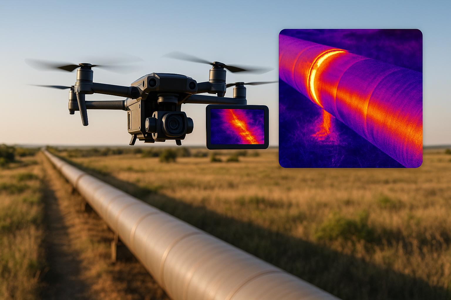
Thermal imaging drones are transforming how pipeline leaks are identified. Equipped with infrared cameras, these drones detect temperature changes caused by leaks, offering faster, safer, and more efficient inspections compared to older methods. They help reduce water loss, prevent costly repairs, and ensure compliance with regulations. By integrating real-time data and AI, operators can quickly pinpoint issues, even in underground pipelines, minimizing risks and expenses. However, challenges like weather sensitivity, limited battery life, and high initial costs remain. Despite these hurdles, thermal drones are shaping the future of pipeline maintenance, saving time and money while improving safety.
Key Points:
- What They Do: Drones use infrared cameras to detect leaks via temperature changes.
- Why It Matters: Early detection saves water, reduces repair costs, and avoids fines.
- Advantages: Faster inspections (e.g., 110 miles/day), reduced safety risks, and lower costs.
- Challenges: Weather conditions, battery limitations, and high upfront costs.
- Future Outlook: Integration with asset management platforms enhances efficiency and decision-making.
Thermal imaging drones are not just tools - they’re reshaping how pipelines are monitored and maintained.
Detecting Gas Leaks with Thermal Sensors on Drones
How Thermal Imaging Drones Find Pipeline Leaks
Thermal imaging drones use advanced infrared sensors to locate pipeline leaks by detecting even the slightest temperature changes. These drones combine infrared cameras with real-time data analysis, offering a highly effective way to identify potential issues before they escalate.
Thermal Camera Technology and Data Collection
Thermal cameras rely on infrared technology to detect gas emissions and temperature shifts that are invisible to the naked eye. For instance, modern systems can identify methane leaks as small as 0.35 g/hr. When a gas or fluid escapes from a pipeline, it causes a temperature change around the leak site. These changes appear clearly on thermal imaging, making it easier to spot the problem. However, the cameras must be carefully calibrated to avoid false readings.
Real-Time Data Transmission and Analysis
Once the data is captured, the focus shifts to efficient analysis. The inspection process begins with mission planning, where operators set predefined routes for the drone or manually fly it while recording the mission for repeatability.
As the drone follows the programmed route, operators monitor the live feed for any anomalies. If a potential issue is detected, the drone can pause to verify the findings. Some systems even incorporate AI to automatically flag areas of concern, helping operators prioritize critical issues. This real-time monitoring ensures that data seamlessly integrates with asset management tools for further analysis.
Detection for Surface and Underground Leaks
Thermal imaging drones are effective for identifying leaks in both surface-level and underground pipelines. They can survey pipelines, valves, and storage tanks from a safe distance, detecting even minor leaks without interrupting operations. For underground pipelines, thermal cameras pick up temperature changes on the ground's surface caused by escaping material, which alters the thermal profile above the leak site.
After the mission, operators analyze the collected thermal images and data to identify defects or areas needing maintenance. This post-mission evaluation ensures that no detail is overlooked, enhancing the overall reliability of pipeline inspections.
Benefits of Thermal Imaging Drones vs. Standard Methods
Traditional pipeline inspections face numerous challenges that thermal imaging drones are uniquely equipped to handle. With more than 630,000 leaks reported in distribution pipelines across the U.S. each year and methane emissions estimated at 1.25–2.66 million tons annually, the urgency for more efficient and accurate detection methods is undeniable.
Efficiency and Accuracy Comparison
When comparing traditional inspection methods to drone-based approaches, the differences in speed, coverage, and accuracy are striking. Manual inspections often require workers to navigate hazardous terrain along pipeline routes, leading to delays and increased risk. Thermal imaging drones, on the other hand, can quickly survey large areas, cutting inspection times from days to mere hours. These drones excel at identifying temperature anomalies, which can indicate leaks that might otherwise go undetected. Ground sensors, while useful, depend on precise placement and may miss intermittent leaks. Similarly, manual inspections relying on human observation often fail to detect smaller leaks.
The cost advantages of drones also stand out. A study by Roland Berger highlights the financial benefits of industrial drone applications:
"Costs for the inspection of an onshore wind turbine can be reduced by 50% per turbine, assessments of large cargo oil storage tanks can be completed several days faster with drones compared to manual methods, and chimney flue inspections can be performed in hours, with savings of up to 90%."
Here’s how the two methods stack up:
| Comparison Factor | Traditional Methods | Thermal Imaging Drones |
|---|---|---|
| Coverage Speed | Days to weeks for large networks | Hours for extensive surveys |
| Safety Risk | High – personnel in hazardous areas | Low – remote inspections reduce exposure |
| Detection Accuracy | Limited by human observation | Thermal sensors detect even small leaks |
| Cost Structure | High labor and equipment costs; potential downtime | Reduced labor and minimal setup costs |
| Environmental Impact | Heavy machinery and vehicles required | Minimal environmental footprint |
| Data Consistency | Varies with inspector experience | Reliable, repeatable measurements |
Thermal imaging drones not only reduce safety risks by keeping personnel out of dangerous environments but also enable faster detection of issues. Early identification of leaks helps prevent major incidents, allowing for quicker repairs and a shift toward proactive maintenance.
Regulatory Requirements for Drone Operations
Despite the operational advantages, using thermal imaging drones for pipeline inspections requires strict adherence to FAA regulations. These rules are vital for ensuring safe and compliant drone operations.
Commercial drone use falls under the FAA’s Part 107 regulations, which require operators to obtain a Remote Pilot Certificate and follow specific guidelines. Some key requirements include maintaining a visual line-of-sight with the drone, flying below 400 feet above ground level, and avoiding flights over people or moving vehicles unless proper waivers are obtained. For inspecting extensive pipeline networks, operators must secure beyond visual line-of-sight (BVLOS) waivers.
Airspace restrictions also play a significant role, especially when pipelines pass near airports or restricted zones. Operators must check Notices to Airmen (NOTAMs) and coordinate with air traffic control when necessary. In some cases, temporary flight restrictions or special coordination with local authorities may be required.
Thorough documentation is another critical component. Operators must log thermal data, flight paths, and detected anomalies to support compliance and improve asset management. Additionally, integrating AI tools into drone operations introduces further regulatory considerations. While AI can help identify potential issues and reduce human error, operators are ultimately responsible for verifying flagged anomalies and deciding on appropriate responses.
sbb-itb-ac6e058
Benefits and Limitations of Thermal Imaging Drones
Thermal imaging drones bring a mix of advantages and operational hurdles. These considerations build on earlier discussions about drone efficiency and regulatory factors.
Main Benefits: Speed, Safety, and Cost Savings
Thermal imaging drones can drastically reduce inspection costs. According to Roland Berger:
"Costs for the inspection of an onshore wind turbine can be reduced by 50% per turbine, assessments of large cargo oil storage tanks can be completed several days faster than with manual methods, and chimney flue inspections, which traditionally require days of shutdown, can be performed in hours, with savings of up to 90%."
Speed and efficiency are also standout benefits. For example, DJI Enterprise managed to inspect over 110 miles of pipeline in a single day - a task that would traditionally take weeks.
Safety is another critical improvement. Kuljeet Singh, Solutions Architect at Wipro's Industrial and Engineering Services division, highlights:
"Traditional methods for pipeline inspection have been slow, manually intensive, expensive and dangerous to conduct."
Thermal imaging drones eliminate the need for human inspectors to traverse hazardous areas, work near high-pressure systems, or enter risky environments. This shift significantly reduces human exposure to danger.
The environmental impact is another plus. Drones consume just 1/100th of the fuel used by helicopters, making them a more fuel-efficient option for monitoring pipelines. They also reduce disruptions to operations since they work from above, avoiding the need for shutdowns or construction of access roads.
With these advantages in mind, it’s essential to also consider the challenges that come with using this technology.
Limitations and Challenges
While thermal imaging drones offer many benefits, they’re not without their challenges. Weather sensitivity is a major issue. High winds, precipitation, and extreme temperatures can make drone operations impossible, delaying essential inspections. Even as the industrial drone market grows - from $17.8 billion in 2023 to a projected $57.9 billion by 2030 - weather remains a persistent obstacle.
Battery life and flight time are other common constraints. Most commercial drones can only fly for 20–40 minutes per charge, requiring frequent battery swaps for longer missions. This limitation can disrupt workflows and reduce efficiency.
The initial investment for high-quality equipment can be steep. For instance, a DJI Matrice 300 paired with a Zenmuse H20T thermal camera costs over $30,000, including software. Additionally, FAA Part 107 certification courses can range from free to several hundred dollars, and hiring professional thermal inspection services can cost anywhere from a few hundred to several thousand dollars per job.
Thermal imaging drones also have their technical limitations. They can only conduct external inspections, meaning internal pipeline conditions remain inaccessible. Thermal sensors have a limited field of view and can struggle with accuracy in windy conditions due to motion sensitivity.
As drone usage grows, data processing becomes increasingly complex. Handling large volumes of thermal imagery requires robust systems for storage, analysis, and security. Organizations must establish clear protocols for data encryption, retention, and AI-assisted analysis tools.
Pros and Cons Comparison
Here’s a quick summary of the main benefits and limitations of thermal imaging drones:
| Aspect | Benefits | Limitations |
|---|---|---|
| Cost | 30% cheaper per hour than traditional methods; up to 90% savings in some cases | High initial investment ($30,000+ for quality equipment) |
| Speed | Can inspect 110+ miles in one day; hours instead of days for inspections | Limited by battery life (20–40 minutes per flight) |
| Safety | Reduces human exposure to hazardous environments | Weather-dependent operations can delay inspections |
| Coverage | Minimal fuel usage (1/100th of helicopters); less environmental disruption | External inspections only; cannot assess internal conditions |
| Data Quality | High-resolution thermal imaging; real-time data transmission | Limited field of view; motion sensitivity can affect accuracy |
| Operations | No need for pipeline shutdowns; minimal disruption | Requires certified operators and ongoing training |
The success of thermal imaging drones depends on aligning their capabilities with operational needs. Organizations should choose sensors suited to their heat detection requirements, ensure drones have sufficient flight endurance for the mission, and employ FAA Part 107-certified operators trained in emergency protocols and site-specific risks.
Regular maintenance, software updates, and sensor calibration are essential to get the most out of this technology. Staying compliant with FAA, OSHA, and state regulations ensures smooth operations. When used effectively, thermal imaging drones can transform pipeline inspection processes, balancing their strengths and limitations to meet modern demands.
Connecting Thermal Imaging Data with Asset Management Platforms
Thermal imaging drones become even more impactful when their data integrates seamlessly with asset management platforms. While raw thermal imagery already provides useful insights, connecting this data to centralized systems transforms it into actionable strategies for pipeline operators. These platforms securely store, process, and analyze large volumes of thermal data, turning isolated visuals into meaningful maintenance insights. This connection bridges the gap between on-site data collection and digital infrastructure models.
Data Storage and Sharing with Anvil Labs
A solid framework for storing and sharing data is key to making this integration work. Anvil Labs offers a secure platform to host thermal imagery alongside 3D models, LiDAR scans, and orthomosaics. This setup allows operators to view thermal anomalies in the full context of their infrastructure. With secure sharing and controlled access, sensitive pipeline data is protected while enabling collaboration among internal teams, contractors, and even regulatory bodies.
A real-world example highlights the value of such integration. Visual Plan and Kestrel Group combined drone-captured thermal imagery with 360° photogrammetry to monitor tank integrity. Using a drone equipped with a FLIR Boson 640R camera, Scott McGowan from Kestrel Group conducted a thermal assessment of a 150-foot-diameter chilled tank from a 20-foot distance. The data was processed within just two hours and delivered to the client in under 48 hours.
"Visual Plan's 360 photos of a tank site - or other critical infrastructure environment - allow for in-environment tagging of individual thermal photographs into the 3D world, providing an actionable location of each identified anomaly, as well as any corresponding data associated with the thermal scanned assets. This efficiency in identifying, locating and understanding the asset information directly translates to realized time and cost savings."
This integration allowed the client to monitor the site remotely, cutting down on physical inspections and improving maintenance planning. By pinpointing thermal anomalies within digital twins of their infrastructure, operators could establish consistent scanning routes, enabling trend analysis and predictive maintenance.
Improving Analysis with AI and 3D Models
Secure data storage is just the beginning. Advanced analysis tools take pipeline oversight to the next level. Anvil Labs integrates AI to process thermal imagery alongside other data, accelerating interpretation and defect detection. The platform’s spatial analysis features map thermal anomalies to precise geographic locations along pipelines, combining this information with 3D models for a comprehensive digital view of the infrastructure.
Anvil Labs reports impressive results: 75% faster inspections, a 30% boost in defect detection, and cost savings in the hundreds of thousands compared to traditional methods. Automated compliance checks also streamline planning, reducing delays and the need for rework.
"My overall experience with the software has been satisfying because of the efficient workflow... The ROI is clearly marked within the first few uses." – Angel Rojas, Red Angel Drones
"This is a differentiator. Those that aren't able to provide visualization but are just doing raw footage - this gives you, in my opinion, that competitive edge." – Adrian, Drone Service Provider
For pipeline operators, combining thermal imagery with repair records creates a documented data trail that supports insurance claims, regulatory compliance, and smarter decision-making. Tools for annotations and measurements allow teams to mark anomalies, add context, and track repairs over time. This builds a dynamic database of pipeline health, improving maintenance strategies and ensuring operational reliability.
Conclusion and Key Takeaways
Thermal imaging drones are reshaping how pipeline leaks are detected, offering a faster, safer, and more cost-effective solution. By tackling major challenges in the industry, they not only deliver financial benefits but also pave the way for streamlined operations.
When it comes to cost savings, drones significantly outshine traditional methods. Inspection costs with drones typically range from $200–$300 per mile, a stark contrast to helicopter inspections that can exceed $1,200 per mile. Considering the oil and gas industry spends roughly $37 billion annually on pipeline monitoring, these savings represent a huge leap forward. For example, one pipeline owner in Oklahoma reported up to 90% savings in remediation costs thanks to early leak detection made possible by drones.
The efficiency drones bring to the table is equally impressive. They can inspect approximately 100 miles in just a few hours - a task that would take weeks using conventional methods. This speed allows for more frequent inspections, reducing the likelihood of small issues escalating into costly disasters.
Safety is another major advantage. By keeping inspectors out of dangerous environments, drones capture high-resolution thermal images that can detect even the smallest leaks. This combination of enhanced safety and precision strengthens the case for widespread adoption.
Beyond the operational benefits, integrating thermal imaging with asset management platforms like Anvil Labs takes things a step further. These tools transform raw thermal data into actionable insights, enabling operators to shift from reactive fixes to proactive maintenance. With features like 3D modeling and AI analysis, platforms like these support preventive maintenance programs that can reduce maintenance costs by 25–30% and prevent 70–75% of equipment breakdowns.
For companies considering this technology, the advantages are clear: quicker inspections, reduced costs, improved safety, and smarter decision-making. The pairing of drone technology with advanced data management tools is setting a new standard for pipeline operations, emphasizing efficiency and environmental care. Drone-based thermal imaging is no longer a futuristic concept - it’s a critical tool for modern pipeline management, ensuring infrastructure integrity while keeping costs under control.
FAQs
How do thermal imaging drones locate leaks in underground pipelines?
Thermal imaging drones are equipped with cameras that detect infrared radiation, making them ideal for spotting leaks in underground pipelines. When a leak occurs, the escaping fluids or gases cause temperature changes that appear as distinct heat signatures. These variations are captured by the drone's thermal sensors, allowing operators to locate the problem with precision.
This approach is both efficient and precise, enabling quicker detection of leaks compared to traditional methods. By identifying issues early, these drones help minimize potential damage and reduce risks to the environment, ensuring pipelines operate more safely and reliably.
What challenges can arise when using thermal imaging drones for pipeline inspections?
While thermal imaging drones bring valuable benefits to pipeline inspections, they come with a few hurdles. For starters, weather conditions such as rain, fog, or strong winds can make it harder for drones to stay stable and may blur the thermal images they capture. In areas with dense vegetation or intricate infrastructure, the drone's line of sight can be blocked, making it tougher to spot leaks.
Other challenges include limited flight time due to battery dependence and the need for highly advanced sensors to function effectively in remote or rugged locations. On top of that, operators must deal with regulatory compliance and prioritize safety, especially when flying in populated or environmentally sensitive zones.
How does using thermal imaging data with asset management platforms improve pipeline maintenance?
Integrating thermal imaging data with asset management platforms takes pipeline maintenance to a whole new level. It enables precise, real-time leak detection, allowing operators to spot potential problems early. Catching these issues sooner rather than later helps avoid expensive breakdowns and keeps downtime to a minimum.
This integration also streamlines the entire maintenance process. Operators can plan repairs more effectively, keep a close eye on pipeline conditions, and create detailed reports to make smarter decisions. The payoff? Better asset reliability, heightened safety, and reduced maintenance expenses. By staying ahead of potential problems, this approach not only keeps pipelines running smoothly but also ensures resources are used wisely.
