Managing underground infrastructure is complex, but simulation tools are transforming the process. Engineers now rely on advanced 3D modeling, numerical simulations, and real-time data integration to design safer, more efficient underground structures. These tools predict stress, fluid movement, and thermal effects, helping avoid costly failures and improving maintenance planning. Key technologies include:
- 3D modeling with LiDAR and photogrammetry for precise geometry and visual insights.
- Digital twins combining real-time sensor data with dynamic models for ongoing management.
- AI and machine learning for predictive maintenance and anomaly detection.
- Multi-physics simulations to analyze structural, thermal, and fluid interactions.
Platforms like Anvil Labs streamline workflows by integrating diverse data types, automating updates, and enabling collaboration. These advancements are reshaping how underground projects are planned, built, and maintained, making them safer and more efficient.
Webinar: Nonlinear Analysis of Tunnel Linings and Underground Structures with DIANA
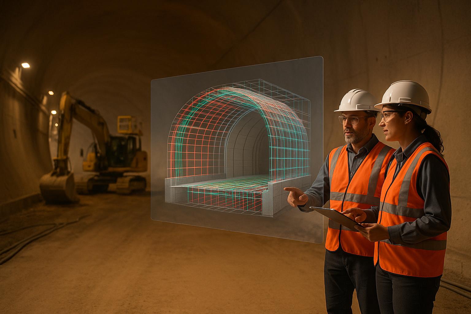
Main 3D Modeling Methods for Underground Structures
Creating accurate 3D models for underground structures comes with unique challenges, such as limited visibility, tight spaces, and complex geometries. Unlike surface modeling, these environments demand specialized techniques to handle restricted access and intricate design elements while providing the detailed data needed for reliable simulations. These methods play a key role in improving the precision of simulations for underground infrastructure.
LiDAR and Photogrammetry for Underground Modeling
LiDAR has become a go-to technology for underground 3D modeling due to its ability to deliver precise measurements in low-light conditions. Using laser pulses, underground LiDAR systems create point clouds that map tunnel walls, structural components, and spatial relationships in remarkable detail. However, managing these large, detailed datasets requires powerful computational tools.
Photogrammetry adds another layer by capturing visual context and texture. This method reconstructs 3D geometry from photographs taken at different angles. In the challenging conditions of underground spaces, photogrammetry demands careful lighting and precise camera placement to overcome issues like poor illumination and confined areas.
When combined, LiDAR and photogrammetry produce textured point clouds that marry precise geometry with realistic details. This integration allows for a deeper analysis of surface conditions, material properties, and potential problem areas that may not be visible through geometric data alone.
Building Information Modeling (BIM) for Underground Design
BIM takes underground design a step further by incorporating operational data into detailed 3D models. Unlike simple 3D representations, BIM models are intelligent and data-rich, embedding information about materials, construction schedules, maintenance plans, and operational parameters. By integrating geological, utility, and structural data, BIM helps streamline the design process and minimizes conflicts during construction.
With its adjustable parameters, BIM allows engineers to see instant feedback on design changes. Specialized tools within BIM platforms make it easier to model complex features, such as tunnel intersections, utility crossings, and other critical connection points. Collaborative workflows enable multiple teams to work on the same model, ensuring that simulation inputs align with the overall design goals.
Model Validation Challenges in Underground Environments
Once models are built, validation is crucial to ensure their reliability for simulations. However, underground environments present unique challenges for validation. Limited access often means that accuracy must be confirmed during the initial data collection phase, leaving little room for on-site corrections later. Traditional surveying methods are often impractical in these confined spaces, making indirect validation techniques necessary. These may include comparing model predictions with reference points or existing as-built documentation.
The ever-changing nature of underground environments - affected by factors like soil conditions, groundwater levels, and structural loads - adds another layer of complexity. One promising solution is sensor integration. By embedding sensors into underground structures, engineers can monitor real-world conditions in real time and adjust models as needed.
Validation typically involves several steps, such as checking geometric accuracy, verifying material properties, and assessing boundary conditions. Platforms like Anvil Labs address these challenges by offering integrated workflows that combine multiple data sources, including LiDAR scans, thermal imagery, and real-time sensor data. This comprehensive approach ensures that models remain accurate and reliable throughout the lifecycle of underground infrastructure projects.
Advanced Simulation Methods for Underground Structures
Once accurate 3D models are in place, advanced simulation techniques turn these digital blueprints into powerful tools for analysis. These methods go beyond simple geometric modeling, helping engineers predict how underground structures will behave under various conditions. From seismic activity to groundwater flow, these simulations provide critical insights to design safer and more durable infrastructure below ground. The following sections dive deeper into these detailed analyses.
Numerical Simulation and Multi-Physics Platforms
Finite element analysis (FEA) is a cornerstone of structural simulation in underground engineering. This method breaks down complex structures into smaller, manageable elements that are analyzed individually. By combining the results, engineers can predict how tunnels, foundations, and support systems respond to different loading conditions.
Multi-physics platforms push this concept further, integrating multiple types of analysis into a single simulation. These platforms can model structural mechanics, heat transfer, fluid dynamics, and electromagnetic effects simultaneously. This is particularly useful for underground projects, where various physical forces often interact in intricate ways.
Dynamic loading scenarios, such as seismic activity, construction blasts, or vibrations from heavy machinery, present unique challenges. Advanced numerical simulations can model these time-dependent forces, helping engineers anticipate how structures will respond under such stresses.
As models grow more detailed, computational demands increase. Modern platforms use parallel processing and cloud computing to handle these intensive calculations. This allows engineers to quickly test multiple scenarios, compare design options, and evaluate different loading conditions. The next section explores how fluid dynamics interacts with structural behavior in underground environments.
Fluid Dynamics and Structural Analysis
Computational fluid dynamics (CFD) is essential for understanding how fluids like water and air move around underground structures. For example, in tunnel design, CFD simulations optimize ventilation systems by analyzing airflow patterns and identifying areas where harmful gases might accumulate.
Groundwater interaction is another critical aspect of underground engineering. CFD models can predict how construction impacts local water tables and how changes in groundwater pressure might affect structural stability. These insights are key for designing effective drainage systems and waterproofing measures.
Reactive transport modeling adds even more depth by incorporating chemical reactions that influence fluid flow. This is especially important in areas with aggressive groundwater conditions or chemical contamination. Engineers can use these simulations to predict material degradation over time and select appropriate protective measures.
Advanced platforms solve fluid and structural equations together, rather than separately, to reach equilibrium. This integrated approach leads to more accurate predictions of how fluids and structures interact in underground environments.
Thermal, Water, and Structural Simulations
Thermal simulations offer another layer of analysis, focusing on how temperature, moisture, and structural loads interact to affect long-term performance.
Thermal analysis is particularly crucial for deep underground structures, where geothermal heat can create significant stresses. Temperature changes can cause materials to expand or contract, which must be factored into structural designs. In colder regions, freeze-thaw cycles add yet another challenge that thermal simulations help engineers address.
Modern simulation platforms include databases of material properties that automatically adjust for local conditions and temperature-dependent behaviors. This ensures more accurate predictions.
Predictive maintenance is one of the biggest benefits of these integrated simulations. By modeling how thermal cycles, water exposure, and structural loads contribute to material wear, engineers can forecast maintenance needs and plan ahead. This proactive approach minimizes unexpected failures and extends the lifespan of underground infrastructure.
Platforms like Anvil Labs combine data from LiDAR, thermal imaging, and sensors, adjusting material parameters in real time to support predictive maintenance. These advanced tools provide a comprehensive understanding of structural performance, helping engineers design underground systems that are safer and more reliable under complex, real-world conditions.
sbb-itb-ac6e058
Combining Drone-Based and Digital Twin Solutions
Bringing together drone technology and digital twin platforms has transformed how underground infrastructure is managed. By combining precise data collection with intelligent digital platforms, engineers can create dynamic digital replicas that enable more accurate simulations and better decision-making throughout a project’s lifecycle. This integration ensures smoother data collection and management, which are critical for effective simulation workflows.
Drone Surveys for Underground Spaces
Drone technology has reshaped the way data is collected for underground infrastructure projects, offering capabilities that go beyond what traditional surveying methods can achieve. Drones equipped with LiDAR technology are especially effective in underground spaces, using laser pulses to gather highly accurate geometric data.
These drones produce high-resolution 2D maps, 3D models, and digital terrain reconstructions through photogrammetry and LiDAR. When combined with GPS data and ground control points, the results are survey-grade accurate models that serve as the foundation for detailed structural evaluations.
Drones excel at surveying underground access points, tunnel entrances, and surface structures tied to subsurface systems. They can cover extensive areas in just hours, which is particularly valuable after events like earthquakes, construction activities, or environmental shifts. The data collected - offering high-resolution imagery and dense point clouds - leads to more precise 3D models, ultimately making simulation results more reliable.
Digital Twin Platforms for Infrastructure Management
Once drones collect the data, it feeds into digital twin systems, turning static 3D models into dynamic, continuously updated representations of underground infrastructure. These platforms integrate data from sensors, inspections, and monitoring systems, ensuring the digital models reflect real-world changes.
Digital twins are especially useful for managing complex systems like subway networks, utility tunnels, or large foundation systems. By analyzing sensor data alongside simulation outputs, these platforms can predict maintenance needs, fine-tune operations, and identify problems before they escalate. Additionally, they support collaborative workflows, allowing different engineering teams to work on various aspects of a project while ensuring everyone has access to the latest information.
How Anvil Labs Improves Simulation Workflows
Anvil Labs takes simulation workflows to the next level by integrating captured data into digital models for more accurate predictive analysis. Their platform handles the entire data process - from collection to final analysis - supporting a range of data types like 3D models, 360° images, thermal scans, LiDAR point clouds, and orthomosaics.
The platform’s annotation and measurement tools let engineers highlight problem areas, document material conditions, and create measurement references that directly integrate into analysis software. These annotations become part of the permanent project record, aiding future maintenance and upgrade efforts.
To enhance collaboration, Anvil Labs employs strict access controls and integrates with tools like Matterport, AI analysis platforms, and task management systems. This seamless connection between simulation results and actionable project tasks makes the platform highly effective for managing the complexities of underground infrastructure projects.
Future Trends and Research in Underground Simulation
Underground simulation is evolving rapidly, incorporating AI, high-performance computing, and standardized workflows to tackle complex subsurface challenges. From predictive maintenance to real-time monitoring, these advancements are transforming how engineers approach underground infrastructure. By building on earlier innovations, these tools are paving the way for the next generation of monitoring and simulation technologies.
AI-Driven Predictive Analytics and Real-Time Monitoring
Artificial intelligence is now playing a key role in predicting failures and optimizing the performance of underground systems. Machine learning algorithms analyze data from sensors, maintenance logs, and simulations, detecting subtle structural changes that might go unnoticed by human analysts.
Real-time monitoring systems have become especially advanced in environments like subway systems and utility tunnels. AI-powered platforms can process data from thousands of sensors at once, comparing real-time conditions to historical trends and simulation models. When anomalies are detected, simulations are automatically triggered to evaluate potential impacts and recommend actions.
The integration of computer vision has further enhanced underground monitoring. AI algorithms can analyze visual data from inspection cameras, identifying cracks, corrosion, or deformation with precision. This automated approach not only speeds up inspections but also improves accuracy, allowing maintenance teams to focus on areas that need immediate attention.
AI-driven predictive models are also helping to forecast maintenance needs years in advance. By optimizing resource allocation and preventing costly emergency repairs, these tools are proving especially valuable for aging infrastructure in large cities.
Exascale Computing and Simulation Scalability
Exascale computing has revolutionized the scale and detail of underground simulations. Engineers can now model entire underground systems with intricate multi-physics integration, capturing interactions between structural, thermal, and fluid dynamics in a single simulation.
What used to take weeks or months to compute can now be processed in a matter of hours. This speed enables rapid scenario analysis, making real-time simulations during construction or emergencies a reality. For instance, engineers can assess potential risks and make informed decisions on the fly.
Parallel processing architectures are another game-changer, distributing calculations across thousands of processing cores. This scalability allows for in-depth modeling of extensive tunnel networks, foundation systems, or utility corridors - particularly important in urban areas where multiple underground systems interact. These capabilities also complement digital twin frameworks, adding another layer of insight.
Cloud-based computing platforms are making these powerful tools more accessible. Smaller engineering firms and municipal agencies can now tap into high-performance computing resources without the need for costly hardware investments. By scaling computational power based on project needs, these platforms are leveling the playing field for organizations of all sizes.
Standardization and Workflow Integration
Standardized data formats and protocols are streamlining collaboration across different software platforms and organizations. This is especially critical for large-scale projects involving multiple disciplines and contractors. By ensuring seamless data exchange, these standards enhance the accuracy of digital twins and support integrated workflows.
Building Information Modeling (BIM) standards tailored for underground structures are becoming more refined and widely adopted. These standards dictate how geometric data, material properties, and simulation results should be structured and shared, reducing errors and improving collaboration. When integrated with simulation data, BIM models create a comprehensive digital record that supports the entire lifecycle of an infrastructure project.
Workflow automation is also gaining traction. Modern platforms can automatically trigger simulations when new data is received, update digital twin models with the results, and distribute findings to the appropriate team members. This automation minimizes manual processing and ensures that everyone is working with up-to-date information.
Application Programming Interfaces (APIs) are further enhancing integration between simulation software, data management tools, and project management systems. These APIs enable simulation results to feed directly into task management workflows, generating work orders or maintenance schedules based on predictive analytics. By breaking down data silos, these tools improve overall project efficiency.
Standardization efforts also extend to quality assurance. Defined validation procedures for simulation models ensure consistency and reliability across projects. These protocols outline testing methods, accuracy benchmarks, and documentation standards, supporting regulatory compliance and professional accountability.
Conclusion: Improving Underground Infrastructure with Simulation
The landscape of underground infrastructure management has undergone a major shift thanks to simulation technologies. Tools like advanced 3D modeling, AI-driven analytics, and digital twins have become central to efficient subsurface projects. By combining these technologies, engineers can make better predictions, speed up decision-making, and lower project risks.
Technologies such as LiDAR, photogrammetry, and BIM provide a solid digital foundation for these efforts. With integrated multi-physics simulations, engineers can now analyze structural, thermal, and fluid dynamics with precision, cutting out much of the guesswork.
AI is also playing a game-changing role. Real-time monitoring powered by AI can forecast potential failures long before they happen. This shift from reactive to preventive maintenance not only reduces costs but also significantly improves safety.
Moreover, cloud computing and standardized workflows are leveling the playing field. Municipal agencies and smaller firms now have access to high-performance simulation tools, enabling them to improve project quality and embrace innovation.
Key Points for Industry Professionals
Here are some takeaways for professionals in the field:
- Unified Data Platforms: Use platforms that integrate various data types - 3D models, thermal images, LiDAR scans, and 360° photos - into a single workflow. This reduces data gaps and simplifies management.
- Anvil Labs as a Case Study: Anvil Labs demonstrates how a comprehensive platform can streamline underground infrastructure projects. Their service supports multiple data formats, offers tailored views, and ensures secure sharing. Starting at $49 per project, it makes advanced simulation tools more accessible.
- Seamless Connectivity: Features like cross-device accessibility and API integrations ensure simulation insights can easily integrate with existing project management systems. This eliminates data silos and enables automated workflows, such as triggering maintenance tasks based on predictive analytics.
For underground projects, where collaboration across disciplines is essential, these integrated solutions provide a major operational edge. Moving forward, success will depend on adopting standardized data practices, implementing automated quality checks, and leveraging AI for smarter decision-making. The next big challenge? Seamlessly embedding these tools into existing workflows.
FAQs
How do LiDAR and photogrammetry work together to create accurate 3D models of underground structures?
LiDAR stands out for its ability to deliver highly precise, millimeter-level measurements and capture intricate structural details, making it perfect for mapping the complex shapes and layouts of underground spaces. Meanwhile, photogrammetry complements this by adding realistic textures and vibrant colors through high-resolution imagery, creating visually detailed representations.
Together, these methods produce 3D models that are not only geometrically precise but also visually immersive. This combination provides a deeper understanding of underground structures, proving extremely useful for tasks like infrastructure planning, analysis, and ongoing maintenance.
How does AI improve predictive maintenance and anomaly detection for underground infrastructure?
AI is transforming predictive maintenance and anomaly detection for underground infrastructure by analyzing real-time data to identify early signs of equipment problems or structural issues. This approach enables maintenance teams to act before small issues escalate, cutting down on downtime and avoiding expensive failures.
With tools like machine learning and deep learning, AI pinpoints patterns and trends that might go unnoticed otherwise. This precision helps make accurate predictions while reducing false alarms. The result? Underground systems become safer, more reliable, and more efficient, paving the way for long-term operational success.
How do digital twin platforms improve the management and maintenance of underground infrastructure?
Digital twin platforms are transforming how underground infrastructure is managed by offering real-time virtual models of physical assets. These digital replicas allow for predictive analysis, which helps spot potential problems early and fine-tune maintenance schedules. This forward-thinking method cuts down on downtime, boosts safety measures, and trims overall expenses.
Through constant monitoring and lifecycle management, digital twins deliver actionable insights that support smarter decision-making. They also simplify intricate processes, leading to smoother operations and better performance for underground systems.
