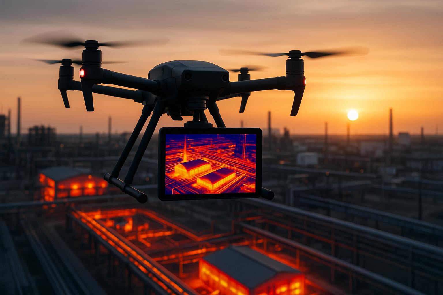
Real-time thermal mapping with drones is transforming how industries monitor, inspect, and respond to challenges. By using drones equipped with thermal cameras, you can instantly detect temperature variations, identify problems like overheating equipment or energy inefficiencies, and improve safety in hazardous areas.
Here’s what you need to know:
- What it is: Thermal drones provide live heat maps, detecting issues like hotspots or subtle temperature changes without time-consuming post-processing.
- How it works: Infrared sensors convert heat data into color-coded maps, while drones ensure access to hard-to-reach areas.
- Key benefits:
- Faster inspections (up to 75% quicker)
- Reduced risks in dangerous environments
- Real-time data for immediate decision-making
- Applications:
- Power line and solar panel inspections
- Building maintenance (detecting leaks, heat loss)
- Emergency response (wildfires, search-and-rescue)
Drones like the DJI Mavic 3 Thermal and Autel EVO II Dual are popular choices, paired with thermal cameras such as FLIR Vue Pro R for precise imaging. Advanced platforms like Anvil Labs simplify data analysis, storage, and sharing, making thermal mapping more efficient and accessible.
Whether it’s predicting equipment failure or improving emergency responses, this technology offers faster, safer, and more accurate solutions across industries.
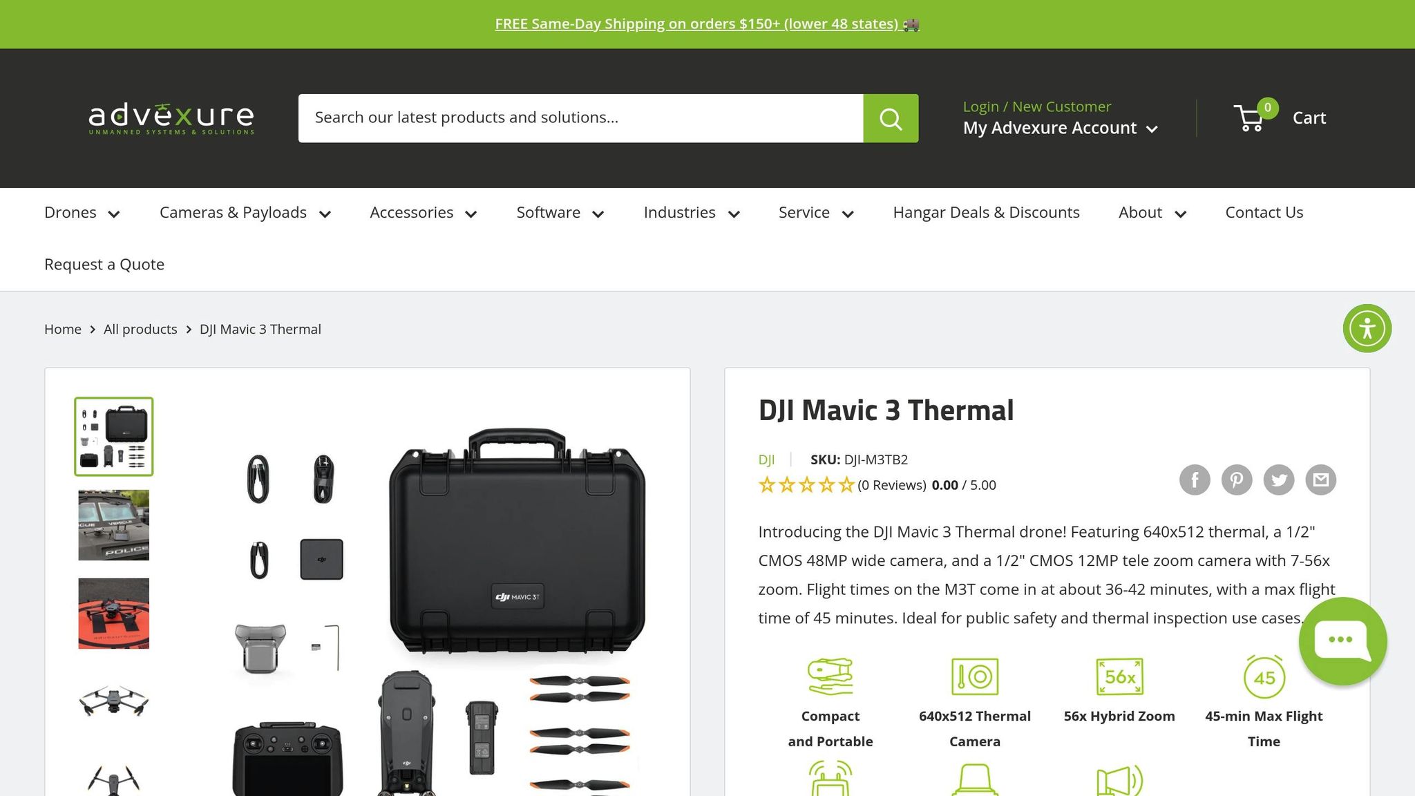
DJI Mavic 3 Thermal Drone: Head of the Class
Equipment and Workflow for Real-Time Thermal Mapping
Real-time thermal mapping demands the right combination of tools, software, and a well-structured workflow. While advancements in technology have made it more accessible, achieving accurate results still hinges on making informed equipment choices and following established processes.
Essential Tools and Technology
The backbone of any thermal mapping operation is the pairing of a reliable drone with a high-quality thermal camera. Popular options include the DJI Matrice 300 RTK, a heavier drone (7.9 lbs) suited for industrial applications, and the DJI Mavic 3 Thermal, a lighter model (2.03 lbs) designed for quick deployments. For a middle-ground option, the Autel EVO II Dual (2.6 lbs) offers integrated FLIR Boson thermal imaging, making it a versatile choice for public safety and utility inspections.
Thermal cameras are equally crucial. Models like the FLIR Vue Pro R and DJI Zenmuse H20T are known for their precision, capable of detecting temperature differences as small as 0.05°C (0.09°F). This level of sensitivity is key for tasks like electrical inspections, where even minor variations can signal potential problems.
| Drone Model | Weight | Thermal Camera | Typical Coverage | Price Range (USD) |
|---|---|---|---|---|
| DJI Matrice 300 RTK | 7.9 lbs | Zenmuse H20T | Large industrial sites | $13,000–$20,000 |
| DJI Mavic 3 Thermal | 2.03 lbs | Integrated thermal | SAR, small inspections | $5,500–$7,000 |
| Autel EVO II Dual | 2.6 lbs | FLIR Boson | Public safety, utilities | $7,000–$9,000 |
Beyond drones and cameras, data management platforms are essential for handling the vast amounts of thermal imagery generated during operations. Tools like Anvil Labs simplify the process by hosting, processing, and sharing thermal data alongside spatial datasets such as 3D models and LiDAR scans. The platform also enables cross-device accessibility and includes annotation and measurement tools to enhance team collaboration.
To complete the setup, ground control stations and real-time streaming software allow operators to monitor live thermal feeds and perform quick analyses mid-flight. Mission planning software ensures efficient flight paths, automated data collection, and compliance with FAA Part 107 regulations.
Step-by-Step Workflow
Thermal mapping follows a structured process to ensure high-quality results and operational safety:
- Pre-Flight Planning: Start with a detailed site assessment and flight path design. Consider airspace restrictions, obstacles, and optimal flight patterns to secure comprehensive coverage while maintaining safety.
- Sensor Calibration: Allow thermal cameras to stabilize for 10–15 minutes to adjust to ambient conditions. Use temperature references like blackbody sources to fine-tune accuracy. Recalibration may be needed if the environment changes significantly during the mission.
- Data Collection: Launch the drone and stream thermal data live to the ground control station. Modern systems use secure wireless links like OcuSync or Wi-Fi to transmit data, enabling operators to view live thermal maps with color gradients that highlight temperature differences. This real-time feedback aids in identifying areas for closer inspection.
- On-Site Analysis: Annotate findings, measure temperatures, and overlay imagery directly in the field. Operators can mark hotspots and document anomalies, prioritizing areas for follow-up inspections.
- Post-Flight Processing: Save both raw and processed data for further analysis. Platforms like Anvil Labs streamline this step by organizing thermal imagery alongside other project files, making it easier for teams to review and share findings.
Environmental and Site Considerations
Environmental conditions can significantly impact data quality and operational safety. Factors like wind, humidity, and precipitation affect drone stability and the accuracy of thermal sensors. High winds may force drones to stay grounded, while humidity can cause lens condensation, reducing image clarity.
The time of day also plays a major role in thermal contrast. Early morning (6:00–8:00 AM) or late evening (6:00–8:00 PM) flights are often ideal, as cooler ambient temperatures enhance the contrast between target objects and their surroundings. Midday solar heating, on the other hand, can obscure thermal signatures, making inspections less effective.
Site-specific challenges require careful planning. For example, reflective surfaces like metal roofs can create false readings, while dense vegetation may obstruct target areas. Uneven terrain might necessitate multiple altitude adjustments to maintain consistent data quality. Pre-site surveys using simulation tools can help operators anticipate and address these challenges.
Additionally, the interaction between thermal energy and different surface materials adds complexity. Materials like concrete, asphalt, vegetation, and water each retain heat differently, creating intricate thermal patterns. Interpreting these patterns accurately requires expertise to distinguish genuine anomalies from environmental noise.
When done correctly, thermal mapping can cover up to 500 acres per flight in agricultural settings and significantly reduce search times - by as much as 75% - in emergency response situations. This demonstrates the value of investing in the right equipment, following systematic workflows, and training operators thoroughly. These practices lay the groundwork for integrating advanced methods and maximizing the potential of thermal mapping.
Methods for Real-Time Thermal Mapping
Real-time thermal mapping is transforming how we analyze and interpret temperature data, making it faster and more precise. These methods turn raw temperature readings into actionable insights, opening up new possibilities for various industries.
Creating Thermal Orthophotos
Thermal orthophotos are one of the standout applications of drone-based thermal mapping. This process involves capturing overlapping thermal images during a drone's flight and using photogrammetry software to stitch them together into a single, georeferenced map. The result? A detailed thermal map that maintains spatial accuracy over large areas.
The secret to creating high-quality thermal orthophotos lies in achieving proper image overlap - typically 70–80% between adjacent images. This overlap ensures that the photogrammetry software can align the images accurately by identifying shared points. Flying the drone at a consistent altitude is also crucial, as it ensures uniform ground sampling distance, which helps prevent distortion in the final map.
GPS precision plays a key role in georeferencing these maps. Systems like RTK (Real-Time Kinematic) and PPK (Post-Processed Kinematic) can refine standard GPS accuracy from several meters to just a few centimeters. This level of precision ensures that thermal maps align perfectly with existing infrastructure and property boundaries.
Photogrammetry platforms such as DroneDeploy and Pix4D simplify the process by handling complex calculations, including correcting for lens distortion, camera angles, and elevation changes. The resulting thermal orthophotos offer a bird's-eye view of temperature distribution across an entire site. For instance, solar farms can use these maps to detect underperforming panels, while building inspectors can identify heat loss patterns on rooftops. Since these maps are georeferenced, temperature data can be tied to specific locations, making maintenance planning and cost estimation much easier.
Combining Thermal Data with Other Data Types
Thermal mapping becomes even more powerful when combined with other types of data. By integrating thermal data with inputs from different sensors, you can uncover insights that wouldn't be possible with a single data source.
One common approach is overlaying thermal imagery with RGB data. RGB images provide visual and structural context, while thermal data highlights temperature anomalies. This combination is particularly useful for electrical inspections, where it helps pinpoint issues like overheating transformers or loose connections by showing both the physical components and their thermal signatures.
Adding LiDAR to the mix introduces precise 3D spatial context. LiDAR point clouds capture the exact geometry of surfaces, while thermal cameras record temperature variations on those surfaces. Together, they enable volumetric analyses, such as measuring heat loss through walls or identifying thermal bridges in complex structures.
Integrating thermal imagery into 3D models takes things a step further. Tools like Anvil Labs allow users to import thermal data alongside 3D models, LiDAR scans, and orthomosaics into a unified workspace. This setup lets teams annotate findings directly on the 3D models, measure distances between anomalies, and share detailed datasets with stakeholders who need both spatial and thermal context.
"This is a differentiator. Those that aren't able to provide visualization but are just doing raw footage - this gives you, in my opinion, that competitive edge." - Adrian, Drone Service Provider
The advantages of multi-modal integration go beyond better visualization. For example, Anvil Labs' drone-based 3D solutions, which combine thermal and LiDAR data, have led to 30% more defect detection compared to traditional single-sensor methods. Inspections are also completed 75% faster, saving clients hundreds of thousands of dollars compared to conventional approaches. These integrated datasets set the stage for advanced AI-driven analytics.
AI and Machine Learning Applications
Artificial intelligence is taking thermal mapping to the next level, turning it into a tool for predictive maintenance. AI algorithms analyze thermal data in real time, identifying anomalies, detecting patterns, and triggering alerts that enable immediate action.
Machine learning models, trained on thousands of thermal images, can automatically detect problems like equipment malfunctions, overheating components, or unusual temperature patterns. These systems often flag issues during the drone flight itself, allowing operators to investigate immediately instead of waiting for post-processing.
Pattern recognition algorithms are particularly effective at spotting subtle thermal signatures that might indicate developing problems. For example, in power grid monitoring, AI can identify thermal patterns that suggest failing insulators or deteriorating connections weeks before they cause outages. Similarly, solar farm inspections benefit from models that differentiate between normal temperature variations and actual panel defects, making maintenance more efficient.
Predictive analytics takes this even further by analyzing thermal data over time. Machine learning models can forecast when equipment is likely to fail, allowing teams to schedule repairs during planned maintenance windows instead of dealing with emergency breakdowns. This capability is especially valuable for critical infrastructure where repair costs are high.
When AI processes data from multiple sensors - thermal, RGB, and LiDAR - it creates even more comprehensive assessments. These models can evaluate an asset's condition by considering temperature, visual appearance, and structural integrity simultaneously.
Organizations adopting AI-powered thermal mapping often see a return on investment within just two months. Faster inspections, better defect detection, and predictive maintenance capabilities lead to significant cost savings, quickly offsetting the initial technology expenses.
As edge computing becomes more advanced, real-time processing is becoming a reality. Modern drones can now run AI algorithms onboard, delivering instant analysis without needing to send data to ground stations or cloud platforms. This capability is especially critical in emergency scenarios, where immediate thermal insights can guide search-and-rescue missions or hazardous material assessments.
sbb-itb-ac6e058
Industry Applications and Use Cases
Real-time thermal data is reshaping how industries operate, offering precise insights that drive smarter, faster decisions. By leveraging thermal mapping, businesses across various sectors are enhancing both safety and efficiency.
Energy and Infrastructure Monitoring
The energy industry has embraced thermal drones to reduce risks and minimize downtime. These drones allow for detailed inspections of transmission lines, substations, and other critical equipment without putting workers in harm's way or halting operations.
One standout use case is power line inspections. Equipped with thermal cameras, drones can identify issues like overheating transformers, failing insulators, and loose connections - problems that might otherwise lead to widespread outages. What's remarkable is that thermal anomalies often appear well before any visible damage, enabling maintenance teams to address issues proactively.
Solar farms are also reaping the benefits. A single drone flight can detect defective solar panels by identifying unusual heat patterns. This targeted approach ensures that underperforming areas are quickly addressed, optimizing energy output and efficiency.
These advancements in energy monitoring highlight how thermal mapping is transforming other fields, such as building inspections.
Building Inspections and Maintenance
Thermal mapping has revolutionized how commercial and residential buildings are inspected. It allows property managers and inspectors to detect issues like heat loss, insulation gaps, and moisture intrusion without needing scaffolding or physically accessing rooftops.
For example, heat loss detection becomes straightforward with thermal imaging. Poor insulation shows up as distinct temperature differences across a building's surface, helping facility managers prioritize energy-saving upgrades.
Thermal imaging also excels at spotting moisture-related issues. Early detection of leaks through temperature variations can prevent costly structural damage down the line.
The time savings are significant. Inspections that used to take days can now be completed in just hours. Angel Rojas from Red Angel Drones shared his experience with the technology:
"My overall experience with the software has been satisfying because of the efficient workflow. I would highly recommend other organizations to use your software simply because of how much value you get for what you pay for... The ROI is clearly marked within the first few uses."
Emergency Response and Search-and-Rescue
Thermal mapping also proves invaluable in emergency situations, where quick and accurate data can save lives. Emergency response teams rely on thermal drones for real-time insights, even in challenging conditions like smoke-filled environments or low visibility.
In wildfire management, thermal drones can navigate through thick smoke that would otherwise hinder helicopters or ground crews. They provide real-time images of fire hotspots, helping teams contain fires more efficiently. For instance, in March 2022, firefighters used thermal drones to assess a blaze, guiding their efforts to prevent the fire from spreading to nearby residential areas.
Fire departments have embraced this technology enthusiastically. Brian Wellington from Litewing noted:
"I showed this to the fire department and they all loved it!"
Thermal imaging is equally critical in search-and-rescue operations. By detecting human body heat, thermal drones can locate missing persons even in dense forests or at night. North Wales police showcased this capability when they used a thermal drone to quickly find a missing pensioner, outperforming a helicopter search in both speed and accuracy.
Emergency services value the ability of these drones to operate under challenging conditions, providing crucial situational awareness. Connor Barnes from Leading Edge Environmental and Emergency Services remarked:
"This streamlines our operations."
These examples highlight how thermal mapping has transitioned from experimental to essential, delivering measurable improvements in safety, efficiency, and cost management across industries.
Managing and Sharing Thermal Data
Once the drone wraps up its thermal mapping flight, what happens next is just as important as the flight itself. Managing the massive datasets produced by thermal cameras requires efficient systems that can handle the hefty file sizes while ensuring the data is easy to access, analyze, and share across your team.
Data Processing and Storage
Thermal imagery files are no small matter - they’re large and require a solid platform to handle them. Cloud-based solutions like Anvil Labs are built for this. They let you securely upload, process, and organize multiple types of data, all within a single workflow. Whether it’s thermal imagery, LiDAR scans, or point clouds, these platforms simplify the process with drag-and-drop uploads and over 20 processing options that turn raw data into actionable insights.
But storage isn’t just about keeping files safe. It’s about making sure they’re ready to use when you need them. With password-protected access, only authorized team members can view the data, and cross-device compatibility means you can check thermal maps on a desktop in the office or on a tablet out in the field. Once uploaded, these platforms allow you to dive right into the data using built-in tools for analysis and annotation.
Viewing and Annotation Tools
After your files are securely stored and organized, the real work begins: analyzing the data. Modern platforms come equipped with viewing and annotation tools that make this process smooth. These tools let you do more than just look at thermal maps - they enable you to mark defects, take measurements, and add notes directly onto the images. This transforms thermal maps from simple visuals into detailed inspection reports.
For example, if you spot a hot spot that signals potential equipment failure or notice unusual heat loss in a building, you can immediately annotate the area with notes, measurements, and even severity ratings. Measurement tools also allow you to calculate the exact size of an anomaly or map out temperature gradients across a surface. This kind of precise data is invaluable for making maintenance decisions and meeting compliance standards.
Adrian, a drone service provider, highlights the importance of these tools:
"This is a differentiator. Those that aren't able to provide visualization but are just doing raw footage - this gives you, in my opinion, that competitive edge."
The ability to analyze and annotate thermal data in detail sets the stage for seamless collaboration and efficient sharing across teams.
Team Collaboration and Data Sharing
Collaboration is where the magic happens. Once your analysis is complete, sharing that data with your team should be quick and hassle-free. Modern platforms make this possible with real-time sharing and controlled access, eliminating the need for endless email chains or physical drives. And because these systems work across devices - smartphones, tablets, laptops, and desktops - you can share thermal data without worrying about losing image quality.
These platforms go a step further by integrating with other tools like task management software and AI-powered analysis systems. This creates a streamlined workflow where, for instance, detecting a thermal anomaly can automatically trigger a maintenance work order or notify the right people immediately.
The results speak for themselves. Companies using advanced thermal data platforms report saving hundreds of thousands of dollars, speeding up inspections by 75%, and identifying 30% more defects. By treating thermal imagery as part of a larger operational ecosystem, businesses can turn this data into a powerful asset that drives efficiency and decision-making.
Conclusion
Real-time thermal mapping with drones is transforming the way inspections, maintenance, and emergency responses are handled. This technology offers quicker operations, lower costs, and precise data collection that traditional methods simply can't replicate. Whether it's pinpointing overheating equipment in power substations or finding survivors in disaster areas, drones equipped with thermal cameras are proving their worth across a variety of industries.
The numbers back it up. Organizations using drone-based thermal mapping report saving hundreds of thousands of dollars while achieving faster inspections and better defect detection. For example, the West Midlands Ambulance Service in the UK has successfully used thermal drones to improve situational awareness during emergency responses, showcasing how versatile this technology can be.
To make the most of these advancements, a strong data management platform is key. Anvil Labs simplifies the entire process - from capturing thermal data to processing, analyzing, and securely sharing it. The platform supports thermal imagery alongside 3D models, LiDAR scans, and orthomosaics, enabling teams to conduct detailed inspections, spot defects, and take accurate measurements. Plus, it ensures cross-device accessibility and automates compliance checks for seamless operations.
With market projections hitting $611.75 billion by 2034 and thermal sensor technology becoming more accessible, organizations that invest in this technology today - combined with efficient data management solutions - can see a return on investment in as little as two months. At the same time, they’ll be setting the foundation for safer and more efficient operations in the years ahead.
FAQs
How can drones with thermal cameras enhance safety in high-risk environments?
Drones fitted with thermal cameras are transforming safety protocols in high-risk environments. By enabling inspections to be carried out remotely, they remove the need for workers to step into dangerous zones. This means less exposure to risks like intense heat, hazardous chemicals, or unstable structures.
The use of thermal imaging also uncovers problems that might otherwise go unnoticed, such as overheating machinery, gas leaks, or hidden fire hazards. With real-time data at their fingertips, teams can respond more quickly and make well-informed decisions to tackle safety challenges head-on.
What should I consider when choosing equipment for real-time thermal mapping with drones?
When choosing equipment for real-time thermal mapping with drones, it’s important to consider a few key aspects to ensure the best results:
- Thermal Camera Quality: Look for drones equipped with high-resolution thermal cameras that can detect precise temperature differences. For U.S. applications, cameras with a wide temperature detection range in Fahrenheit are ideal.
- Drone Compatibility: Make sure the thermal imaging system is fully compatible with the drone. Many drones are specifically designed to work seamlessly with particular cameras and software systems.
- Battery Life and Flight Time: A drone with a longer battery life is essential for extended mapping sessions, especially when covering larger areas without frequent interruptions.
- Data Processing and Analysis Tools: Choose equipment that enables real-time data processing and works with platforms like Anvil Labs for detailed spatial analysis and secure data sharing.
By keeping these factors in mind, you’ll be better equipped to perform accurate and efficient thermal mapping that meets your specific requirements.
How do AI and machine learning improve drone-based thermal mapping?
AI and machine learning are revolutionizing drone-based thermal mapping by making data processing faster, increasing accuracy, and delivering insights that can drive better decisions. These advanced technologies can handle massive datasets in real time, uncovering patterns and spotting anomalies in thermal imagery that might slip past human analysis.
Here’s how they make a difference:
- Improved precision: AI algorithms excel at detecting subtle temperature changes, making it easier to pinpoint issues like overheating equipment or energy losses.
- Automation at work: Machine learning streamlines tasks such as mapping, classification, and reporting, cutting down on time and minimizing the chance of human error.
- Looking ahead with predictions: By examining historical data, AI can forecast trends and identify potential failures, enabling proactive maintenance and smarter planning.
By combining AI and machine learning with drone technology, industries like energy, construction, and agriculture are turning thermal mapping into a more efficient and intelligent process.
