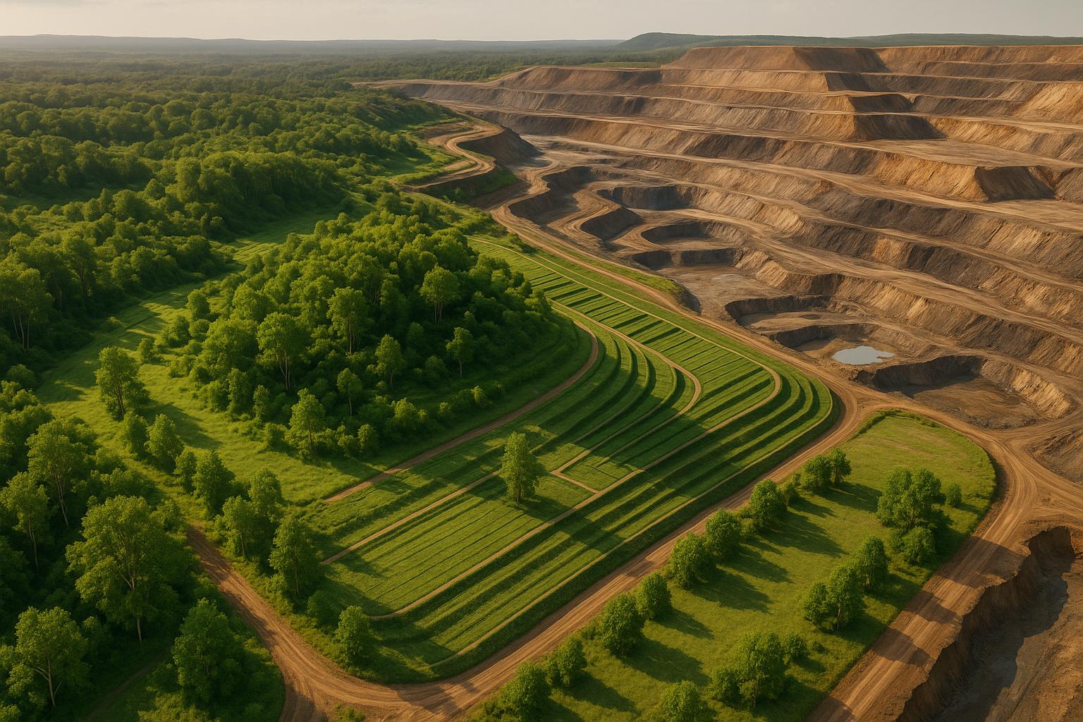
LiDAR (Light Detection and Ranging) is transforming how mining companies restore land after operations. By using laser pulses to create precise 3D maps of terrain, it helps teams plan and monitor rehabilitation projects with unmatched accuracy. Key benefits include:
- High Precision: LiDAR captures terrain details down to ±8 mm, identifying erosion, vegetation growth, and landform stability.
- Safety: Remote data collection eliminates the need for personnel in hazardous areas.
- Efficiency: Surveys cover hundreds of acres in hours, cutting time and costs by up to 75%.
- Cost Savings: Projects often see a return on investment within two months.
- Regulatory Compliance: LiDAR data simplifies reporting and ensures adherence to closure standards.
How to take a holistic approach to mine rehabilitation and closure - Decipher
Key Benefits of LiDAR for Mine Rehabilitation
LiDAR brings a new level of precision, safety, and efficiency to mine rehabilitation projects. By incorporating LiDAR into their workflows, mining companies can dramatically improve how they plan and execute rehabilitation efforts. The technology streamlines operations and enhances the accuracy of critical decisions.
High-Resolution Data and Accuracy
LiDAR stands out for its ability to capture incredibly detailed measurements, often down to the millimeter. For instance, ground-based LiDAR systems can achieve precision within ±8 mm, making it possible to monitor post-mine landscapes and vegetation with exceptional detail. This precision allows teams to evaluate essential landform features like slope angles, berm widths, and vegetation heights. Unlike manual surveys, which can involve a degree of guesswork, LiDAR provides objective and repeatable data, crucial for both operational decisions and regulatory compliance.
A standout example comes from Australia, where the Soilwater Group used ground-based LiDAR over several years to monitor a rehabilitated waste rock landform. The data helped validate the stability of the landform and track vegetation growth, enabling targeted interventions where needed.
Better Safety and Efficiency
One of LiDAR's standout advantages is its ability to protect personnel by enabling remote data collection. This is particularly valuable in hazardous areas like unstable slopes, steep embankments, or regions prone to rockfalls and subsidence. By keeping workers out of dangerous terrain, LiDAR significantly reduces on-site risks.
LiDAR systems also excel in efficiency. They can scan vast areas - often hundreds of acres - in a single day. This speed allows for frequent monitoring and timely updates to rehabilitation plans, which supports quicker decision-making and adaptive management throughout the project lifecycle.
Cost and Time Savings vs Standard Methods
When compared to traditional surveying methods, LiDAR offers clear financial and time-saving benefits. Inspections can be completed up to 75% faster, with cost savings reaching hundreds of thousands of dollars. Many projects see a return on investment in just two months.
| Method | Time Required | Labor Intensity | Cost (approx.) | Data Accuracy | Coverage Area |
|---|---|---|---|---|---|
| LiDAR (Drone/Ground) | Hours–Days | Low | $1,500–$5,000 per survey | ±8 mm | Large (100s of acres) |
| Standard Surveying | Days–Weeks | High | $5,000–$15,000 per survey | ±10–50 cm | Small–Medium (10s of acres) |
Costs are illustrative and may vary depending on location and project size. LiDAR delivers greater accuracy and coverage with fewer resources.
LiDAR's cost advantages stem from its ability to minimize labor, speed up data collection, and reduce the number of site visits required. While traditional methods might take days or even weeks to survey a large area, LiDAR can accomplish the same tasks in just a few hours with a smaller team. Research shows that LiDAR can reduce data collection time by 80% and cut labor costs in half, all while delivering superior accuracy.
"My overall experience with the software has been satisfying because of the efficient workflow. I would highly recommend other organizations to use your software simply because of how much value you get for what you pay for... The ROI is clearly marked within the first few uses."
– Angel Rojas, Red Angel Drones
Beyond immediate savings, LiDAR's precision helps avoid costly mistakes. By identifying potential issues early, it prevents expensive rework and delays. For example, Eagle Mapping reports that mining clients using LiDAR for rehabilitation monitoring achieved quicker regulatory approvals and avoided setbacks by catching problems early with high-resolution, reliable data. This proactive approach can save months of delays and significant costs in the long run.
How to Use LiDAR in Mine Rehab Planning
Using LiDAR effectively in mine rehabilitation involves three main steps: collecting and processing data, analyzing the results, and fostering collaboration through digital platforms.
LiDAR Data Collection and Processing
The first step in leveraging LiDAR is careful planning, whether you're using drones or ground-based systems. Strategic flight paths or equipment placements are essential to ensure full site coverage while maintaining safety standards. During data acquisition, LiDAR sensors capture millions of data points every second, producing an intricate point cloud of the landscape.
Once the data is collected, it undergoes processing to filter out noise and classify elements like vegetation, ground surfaces, and structures. Specialized software transforms this cleaned-up data into 3D surface models, digital elevation models (DEMs), and orthomosaics, which provide a clear visual representation of the site. These georeferenced models are crucial for analyzing the site and presenting findings to stakeholders.
A great example of this process in action comes from Dendra Systems in 2022. They used drone-mounted LiDAR to survey a large mine rehabilitation site in Australia. Their efforts produced detailed 3D models that helped monitor erosion and assess vegetation regrowth. These insights not only supported regulatory reporting but also ensured they met closure goals successfully.
This processed data becomes the foundation for conducting a thorough rehabilitation analysis.
Analyzing LiDAR Data for Rehab Insights
LiDAR data provides valuable insights into three key areas of mine rehabilitation: erosion, vegetation regrowth, and landform stability. By comparing data from multiple surveys over time, teams can track changes in elevation, surface area, and slope. This time-series analysis highlights areas at risk of degradation and informs targeted corrective actions.
Erosion monitoring is particularly effective with LiDAR, as it can detect tiny terrain shifts that signal instability. For example, changes in elevation can indicate soil loss or buildup, while slope analysis pinpoints areas that might need extra support. The Soilwater Group in Australia used ground-based LiDAR over several years to monitor rehabilitated waste rock landforms. Their highly accurate measurements - down to the millimeter - helped validate landform stability and secure regulatory approval.
LiDAR also excels in tracking vegetation regrowth. High-resolution data makes it possible to measure subtle changes in terrain and vegetation cover. When paired with AI tools, LiDAR can even identify plant species, monitor invasive growth, and assess the success of revegetation efforts. This data-driven approach supports adaptive management and regulatory compliance.
Additionally, LiDAR ensures landforms meet design specifications by identifying construction deviations with exceptional accuracy - up to ±8 mm for ground-based systems. This helps avoid long-term stability issues and ensures regulatory requirements are met.
These insights are best utilized when teams collaborate using modern digital platforms.
Using Digital Platforms for Team Collaboration
To make the most of LiDAR data, teams need robust digital platforms for managing information and fostering collaboration. Platforms like Anvil Labs are designed to handle large LiDAR datasets, offering tools for annotation, measurement, and customizable viewing. These platforms allow access across devices and integrate various data types, such as 3D models, 360° imagery, and thermal scans, creating a centralized hub for planning.
Role-based access controls ensure sensitive data stays secure while allowing engineers, ecologists, and regulators to track progress transparently. Features like version control and audit logs maintain data integrity, supporting accountability throughout the project.
"My overall experience with the software has been satisfying because of the efficient workflow. I would highly recommend other organizations to use your software simply because of how much value you get for what you pay for... The ROI is clearly marked within the first few uses." – Angel Rojas, Red Angel Drones
These platforms also streamline reporting. Teams can securely share annotated 3D models and analysis results, create presentations to highlight key findings, and generate reports that meet regulatory standards. This centralized approach minimizes delays and ensures everyone works with up-to-date information.
Beyond hosting data, platforms like Anvil Labs integrate with task management tools and AI systems to automate workflows. For instance, they can flag areas that need attention, reducing manual oversight and ensuring critical issues are addressed promptly.
Regular LiDAR surveys - usually conducted annually or after major interventions - provide the data needed to track progress over time. By combining accurate data collection, insightful analysis, and streamlined collaboration, LiDAR simplifies and enhances the entire mine rehabilitation process.
sbb-itb-ac6e058
Applications and Best Practices for LiDAR in Mine Rehabilitation
LiDAR technology stands out as a game-changer for mine rehabilitation, offering precise monitoring and data-driven decision-making. By applying its practical uses and following proven strategies, mining operators can navigate the challenges of site restoration while staying compliant with regulations.
Practical Uses in Post-Mining Rehab
Erosion Monitoring and Control is a standout application of LiDAR in mine rehabilitation. With the ability to create detailed digital terrain models (DTMs), LiDAR provides accurate insights into erosion depths, surface areas, and topographical changes. This makes it possible to detect even minor shifts in terrain that could signal instability before they escalate into major problems. Notably, LiDAR can also penetrate dense vegetation, ensuring under-canopy erosion is effectively monitored.
Landform Compliance Auditing is another area where LiDAR excels. Its high-resolution mapping capabilities allow for precise comparisons between constructed landforms and approved rehabilitation designs. This ensures that slopes, drainage systems, and other features align with regulatory requirements. For example, digital elevation models generated from LiDAR data provide clear, objective evidence to verify compliance. A project by the HALO Trust in Cuito Cuanavale, Angola, highlights LiDAR's effectiveness in challenging environments. Between 2023 and 2024, a 16-channel LiDAR sensor mounted on a drone uncovered 496 meters of main trench and 40 meters of communication trenches - features that satellite imagery failed to detect.
Vegetation Recovery Assessment benefits greatly from LiDAR's ability to measure vegetation height, density, and spatial distribution across large areas. By conducting repeated surveys, teams can evaluate the success of revegetation efforts and identify areas needing additional attention. Integrated AI tools further enhance this process by automatically detecting invasive species and prioritizing weed control, streamlining vegetation assessments across entire sites.
Infrastructure and Stability Monitoring is made more effective with continuous LiDAR surveys, which can detect structural changes early on. This proactive approach supports maintenance schedules and helps identify deformation or movement before they become significant hazards. Consistency in monitoring aligns with earlier insights into the importance of early problem detection.
Best Practices for Effective LiDAR Use
To fully harness LiDAR's capabilities in mine rehabilitation, implementing specific best practices is essential:
- Conduct Regular Surveys: Schedule surveys consistently, such as quarterly or after extreme weather events, to track site changes over time. This builds a reliable dataset for trend analysis and regulatory reporting.
- Utilize High-Density Data Capture: Modern LiDAR systems can collect millions of data points per second - some reaching up to 600,000 points per second. Quick processing and comparison with earlier datasets are crucial for making timely decisions.
- Integrate Multiple Data Sources: Combine LiDAR data with other tools like orthomosaics, 360° photos, thermal imagery, and ecological data for a well-rounded view of site conditions. For instance, pairing LiDAR's topographic data with multispectral imagery can improve vegetation health assessments, while thermal data can reveal subsurface water flows or heat anomalies.
- Adopt Collaborative Digital Platforms: Platforms like Anvil Labs allow engineers and stakeholders to remotely access, visualize, and analyze LiDAR data. These tools enable faster inspections - up to 75% quicker - and improve defect detection rates by 30% compared to traditional methods.
- Leverage AI Tools: Use AI-powered systems to automatically identify key features such as invasive species, erosion patterns, and vegetation changes. This reduces the need for manual oversight and speeds up intervention planning.
- Document Progress Clearly: Set clear rehabilitation goals and measurable metrics before starting LiDAR surveys. This ensures the data collected aligns with specific objectives, providing a solid foundation for regulatory compliance and transparent stakeholder reporting.
- Ensure Data Security and Access Control: Protect sensitive information with strict access protocols while allowing stakeholders, ecologists, and regulators the transparency needed to monitor progress effectively.
Additionally, careful planning of UAV operations in hazardous terrain can maximize the potential of extended flight capabilities.
These best practices align seamlessly with broader regulatory and reporting workflows, setting the stage for effective mine rehabilitation efforts.
Regulatory Compliance and Reporting with LiDAR
In the U.S., mine rehabilitation requires meticulous documentation to meet closure targets. LiDAR technology is a game-changer here, offering precise, high-resolution data that's both objective and auditable - exactly what's needed to meet strict regulatory standards.
Meeting Rehabilitation Standards with LiDAR
LiDAR works by capturing millions of data points every second, creating terrain models with centimeter-level precision. This allows mining companies to document critical factors like landform stability, erosion, vegetation regrowth, and backfill volumes. When combined with AI, LiDAR can automate compliance checks, eliminating the inaccuracies of manual tracking and delivering reliable, actionable insights. The results? Companies have reported substantial benefits, including saving hundreds of thousands of dollars, cutting inspection times by 75%, and detecting defects 30% more effectively.
In one notable project, LiDAR and AI generated detailed, auditable reports that streamlined the documentation of rehabilitation progress. The technology also simplifies baseline and ongoing rehabilitation mapping. Operators can record conditions right after mining operations end and then track improvements over time with repeatable, high-accuracy surveys.
| Compliance Method | LiDAR-Based Reporting | Traditional Surveying |
|---|---|---|
| Data Resolution | Centimeter/millimeter scale | Meter scale |
| Auditability | High (digital, timestamped) | Lower (manual records) |
| Efficiency | Rapid, repeatable | Labor-intensive, slower |
| Safety | Remote, minimal fieldwork | More on-site exposure |
| Visualization | 3D models, interactive maps | 2D maps, static reports |
Presenting LiDAR Data to Stakeholders
Communicating complex LiDAR data to stakeholders requires transforming it into clear, accessible visualizations. Beyond its compliance advantages, LiDAR also excels at engaging both technical and non-technical audiences. Annotated 3D models and time-lapse digital terrain maps provide compelling visual evidence of rehabilitation progress. Secure, centralized platforms make this even easier by enabling data hosting, secure sharing, and customizable visualizations. These platforms also integrate seamlessly with other data formats, like 360° photos and orthomosaics.
Standardized before-and-after metrics make regulatory reviews straightforward. For instance, erosion-prone areas or zones of vegetation regrowth can be highlighted directly on 3D models, complete with metadata for traceability. This dynamic approach replaces static reports, allowing stakeholders to explore the progress from multiple perspectives.
A great example of this comes from the HALO Trust's work in Angola. Using UAV LiDAR mapping, they identified battlefield features - like trenches and craters - that satellite imagery missed. These craters averaged 5.85 meters wide and 0.65 meters deep, showcasing LiDAR's ability to uncover critical details.
LiDAR-generated quantitative reports can be exported in formats tailored for regulatory submissions or public presentations. These reports include precise measurements of achievements like vegetation growth, erosion control, and slope stability, reducing manual calculation errors and simplifying regulatory preparation.
Additionally, cross-device accessibility ensures stakeholders can review progress remotely, cutting down on the need for site visits while maintaining transparency. By pairing clear, non-technical explanations with rigorous data, mining companies can meet regulatory reporting cycles more effectively. Engaging with regulators early to confirm reporting formats and expectations further minimizes approval delays.
Conclusion: The Future of Mine Rehab with LiDAR
LiDAR is reshaping mine rehabilitation by turning what was once a labor-intensive process into a precise, data-driven operation. With its millimeter-level accuracy, it’s changing how the mining industry tackles environmental responsibilities and stays compliant with regulations.
The benefits are hard to ignore. Companies are reporting inspections that are 75% faster, detecting 30% more defects, and saving hundreds of thousands of dollars - with a return on investment in just two months. Beyond these measurable gains, LiDAR is also boosting field safety and streamlining operations in ways traditional methods just can’t match.
Regulators are also adapting, with agencies like the Office of Surface Mining increasingly leaning on objective, data-backed evidence for compliance checks. LiDAR’s ability to provide repeatable, verifiable measurements gives it a critical edge over older methods. As the technology evolves, we’re likely to see AI-powered analysis integrated with LiDAR, automating compliance checks and reducing errors tied to manual processes. Platforms like Anvil Labs are already making LiDAR data more actionable by blending spatial datasets - like 3D models, thermal imagery, and orthomosaics - into unified systems that enable smooth collaboration and secure stakeholder communication.
One of LiDAR’s standout features is its ability to collect millions of data points per second while minimizing the need for personnel to enter dangerous areas. This isn’t just a leap in efficiency - it’s a major step forward in safety as well. Early adopters are already using LiDAR to establish baseline conditions during the planning stages and to monitor ongoing progress, ensuring predictive models hold up throughout the rehabilitation process.
Another game-changer? LiDAR turns raw data into high-quality visualizations, giving mine operators actionable insights that provide a real competitive edge.
For mining companies, the message is clear: adopting LiDAR technology early, training staff to use it effectively, and integrating it with digital platforms are no longer optional. These steps are key to staying ahead - both in meeting stricter environmental standards and in running more sustainable and cost-efficient operations. Those who embrace this shift now are setting themselves up for success in the future of mine rehabilitation.
FAQs
How does LiDAR technology enhance safety and efficiency in mine rehabilitation planning?
LiDAR technology plays a key role in boosting safety and efficiency during mine rehabilitation by delivering highly accurate 3D maps of the terrain. These detailed maps allow project planners to pinpoint potential dangers - like unstable ground or steep slopes - before work even starts, helping to reduce risks for workers on-site.
Beyond safety, the precision of LiDAR data also simplifies the planning process. It enables smarter resource allocation and more effective rehabilitation designs. Plus, because LiDAR can quickly gather data across large areas, it cuts down the need for manual surveying. This not only saves time but also ensures the entire process is safer and more efficient.
How does LiDAR technology streamline mine rehabilitation planning?
LiDAR technology has transformed mine rehabilitation by offering highly accurate, detailed 3D mapping of landscapes. With this data, planners can thoroughly evaluate terrain conditions, pinpoint potential environmental challenges, and craft restoration plans that address the unique requirements of each site.
The process usually starts with collecting LiDAR data, often using drones or similar platforms. This raw data is then processed into accessible formats and analyzed to produce digital terrain models. These models are invaluable for simulating post-mining scenarios, enabling smarter resource allocation and ensuring adherence to environmental standards. Thanks to LiDAR, teams can streamline their efforts, cut down on expenses, and significantly enhance the success of rehabilitation projects.
How does LiDAR help ensure compliance and streamline reporting in mine rehabilitation projects?
LiDAR technology is a game-changer for meeting regulatory requirements and streamlining reporting in mine rehabilitation projects. By collecting detailed 3D data of landscapes after mining activities, it enables precise tracking of site conditions and progress. This precision is crucial for adhering to strict environmental and safety standards.
The data gathered through LiDAR can also be transformed into clear reports featuring visualizations, measurements, and spatial analyses. These reports simplify the process of sharing updates with stakeholders and regulators, ensuring everyone stays informed and accountable during the rehabilitation journey.
