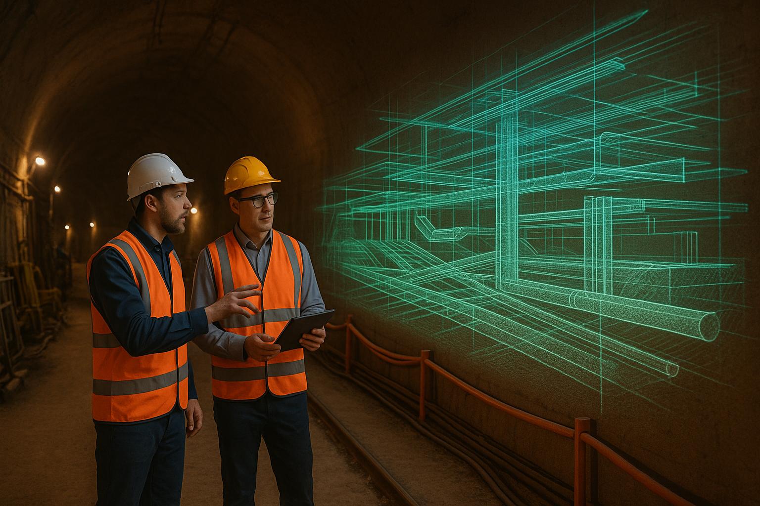
LiDAR is reshaping how underground spaces like tunnels, mines, and utility corridors are modeled. By emitting laser pulses to measure distances, it generates precise 3D maps even in areas where GPS fails. This technology offers faster, more accurate results compared to older methods, while reducing risks for workers in hazardous conditions. Key benefits include improved safety, detailed documentation, and seamless use with advanced tools like BIM and digital twins. However, challenges like scan alignment, environmental interference, and processing large datasets require careful planning and validation.
Key Points:
- How it works: LiDAR uses laser pulses to create detailed 3D models, even in dark, GPS-limited areas.
- Challenges: Issues like GPS absence, dust, and complex geometries need advanced tools and techniques.
- Benefits: Faster data collection, safer operations, and precise models for infrastructure management.
- Tools: Handheld, vehicle-mounted, and backpack scanners cater to different underground scenarios.
- Data processing: Noise filtering, scan alignment, and AI-based analysis refine raw data into usable models.
- Future trends: Real-time monitoring, AI for predictive maintenance, and more affordable sensors.
LiDAR's precision and efficiency make it indispensable for underground infrastructure projects, and its evolving capabilities promise even greater utility in the years ahead.
LiDAR technology in underground construction
LiDAR Tools and Data Collection Methods
Selecting the right LiDAR equipment and deployment strategy is crucial for capturing accurate underground data. Underground environments often come with tight spaces, limited access, and strict safety requirements, which demand specialized tools and meticulous planning. Below, we’ll explore the tools and methods that help meet these unique challenges.
Types of LiDAR Scanners for Underground Use
Different underground scenarios require different types of LiDAR scanners, each designed to address specific needs:
- Handheld mobile scanners: These are favored for their portability and ease of use. They continuously collect point cloud data while moving through tunnels, and their built-in inertial measurement units (IMUs) ensure accurate positioning in areas where GPS signals are unavailable.
- Terrestrial laser scanners: Mounted on tripods, these scanners are ideal for stationary applications. They take longer to set up and may require multiple scan positions to cover complex spaces, but they excel at capturing detailed structural features and connections.
- Vehicle-mounted systems: Perfect for surveying larger underground spaces like subway tunnels or mining corridors, these systems combine fast scanning capabilities with precise navigation to efficiently cover extensive areas.
- Backpack-mounted scanners: These offer a blend of portability and advanced sensing capabilities, making them suitable for environments with stairs, narrow passages, or areas inaccessible to vehicles.
How to Deploy LiDAR in Underground Environments
Successful underground LiDAR deployment begins with thorough site evaluation. This includes assessing ventilation, identifying hazards, and planning access routes to choose the most suitable scanner for the job. Combining handheld scanners with stationary systems often provides the best balance of coverage and precision.
Safety is a top priority. Teams should establish clear communication, ensure proper ventilation, and clearly mark emergency evacuation routes. In areas where hazardous gases are a concern, gas monitoring devices are essential. Teams should work in pairs, with one member operating the scanner and the other focusing on safety.
Since GPS signals are typically unavailable underground, inertial navigation systems are critical. Many modern LiDAR systems use simultaneous localization and mapping (SLAM) algorithms to track the scanner’s position by analyzing the geometry of the captured points. However, SLAM systems can experience drift over long distances. To counter this, survey teams should incorporate control points using traditional methods or establish loop closures to maintain accuracy. This combination of safety measures and precise positioning ensures reliable data collection for creating accurate 3D models.
Environmental conditions like dust, moisture, and temperature fluctuations can affect laser performance. Choosing the right laser wavelengths and scheduling scans during periods of minimal activity can help reduce interference from airborne particles and vibrations.
Data Collection Workflows
A well-organized workflow is key to successful underground LiDAR scanning. Start with pre-scan planning: map the area, identify key features, and determine optimal scan positions. This preparation helps streamline fieldwork and ensures no critical areas are missed.
During scanning, aim for overlapping scans and review point cloud data in real time to confirm full coverage. In complex environments, strategically positioning scanners in main tunnels, side passages, and areas with varying elevations provides reference points for accurate alignment during reconstruction.
Managing field data effectively is just as important as collecting it. Regularly back up data to multiple storage devices and use clear file naming conventions to stay organized, especially on larger projects. Documenting environmental conditions, equipment settings, and scan sequences also supports quality control during later processing.
To minimize the need for repeat scans in hazardous areas, implement quality control steps throughout the process. This includes verifying scanner calibration, checking battery levels, monitoring environmental conditions, and ensuring data integrity at every stage. These precautions not only improve efficiency but also enhance the overall reliability of the final results.
Processing and Refining LiDAR Data for 3D Models
Turning raw LiDAR data into precise 3D models requires careful handling to address issues like noise, alignment, and spatial accuracy. This meticulous process lays the groundwork for creating reliable digital twins of underground infrastructures. Let’s break down how raw data evolves into refined point clouds and accurate models.
Point Cloud Generation and Refinement
At its core, raw LiDAR data consists of countless laser measurements. These measurements are processed into point clouds by combining distance data with the scanner's positional information. Each point is assigned a 3D coordinate, forming the foundation for further refinement.
The first step is noise filtering. Underground environments are notorious for introducing noise into scans. This could be stray points caused by environmental factors or moving objects like people or machinery. Algorithms like statistical outlier removal target and eliminate these outliers, while moving object filters remove points linked to transient objects captured during scanning.
Next is density optimization. Point density can vary depending on the scanner's distance and speed. Close-range scans might have an overwhelming density of points, slowing down processing without adding accuracy, while distant areas might have gaps. Uniform sampling algorithms address this by reducing over-sampled regions and interpolating where necessary, ensuring a balance between detail and efficiency.
Surface classification is another crucial step. Using machine learning, the software can identify and categorize elements like walls, floors, ceilings, pipes, and equipment based on their geometric properties. This pre-organizes the data, simplifying the modeling process later.
Finally, edge detection and feature extraction focus on preserving critical details. Features like sharp edges, corners, and linear structures (e.g., pipes or cables) are enhanced using filters that retain these important structural elements.
Georeferencing and Scan Alignment
Underground scans face unique challenges, especially since GPS signals aren’t available. This makes scan registration vital when working with data from multiple scanner positions or different equipment.
To align scans, control points - known coordinates within the dataset - act as anchors. ICP (Iterative Closest Point) algorithms refine alignment by adjusting the position and orientation of overlapping scans until they match within acceptable tolerances. This method works best when scans have significant overlap and distinct geometric features.
For longer scanning paths, loop closure correction is essential. SLAM-based systems can accumulate errors over time, causing misalignment. When the scan path loops back to a previously mapped area, the algorithm redistributes errors across the path, ensuring proper alignment and avoiding distortions like the "bow-tie" effect.
Bundle adjustment takes alignment a step further by optimizing all scan positions and control points simultaneously. This global optimization method is particularly effective for complex underground networks with intersecting tunnels.
Lastly, coordinate system transformation ensures that the underground model aligns with surface infrastructure and engineering drawings. This often involves converting the scanner's local coordinate system to standard mapping projections like State Plane coordinates or UTM zones, commonly used in U.S. projects.
Software Tools and Automation
The heavy lifting in LiDAR data processing is done by specialized software designed to handle the massive datasets typical of underground scanning. Tools like CloudCompare, Leica Cyclone, and Trimble RealWorks offer features for registration, filtering, and model generation.
Modern workflows rely heavily on automation. These tools can automatically apply noise filtering, align scans, and create preliminary models, significantly reducing manual effort. However, manual review remains critical, especially in complex environments.
Machine learning integration is transforming feature recognition and classification. Neural networks trained on underground data can automatically identify pipes, conduits, structural elements, and equipment, making the modeling process faster and more consistent for large-scale projects.
Quality control algorithms play a key role in maintaining accuracy. They flag potential issues like low point density, misaligned scans, or deviations from geometric constraints. This ensures that errors are caught early, keeping the data reliable.
For projects involving repeated scans of the same areas, batch processing capabilities are invaluable. These allow you to apply consistent processing steps across multiple datasets, ensuring uniform standards for ongoing monitoring efforts.
Once the data is processed, integration with 3D modeling platforms ensures a seamless transition from raw point clouds to finalized infrastructure models. Direct data exchange formats preserve spatial accuracy and metadata, ensuring the precision achieved during scanning carries through to the final deliverables.
Processing times depend on the complexity and volume of data, but automated workflows often process a full day’s worth of scans overnight. This quick turnaround supports time-sensitive projects and allows teams to validate fieldwork promptly, ensuring everything stays on track.
sbb-itb-ac6e058
Integrating LiDAR Data into 3D Modeling Platforms
Integrating processed LiDAR data into 3D platforms is a crucial step in turning raw point clouds into actionable digital models for managing infrastructure and making informed decisions.
Importing LiDAR Data into 3D Platforms
Modern 3D platforms are designed to handle standard point cloud formats like LAS, LAZ, PLY, and XYZ files, but successful integration requires careful attention to file compatibility, coordinate systems, and data management.
File format compatibility is key. LAS and LAZ formats are widely used because they preserve essential details like spatial coordinates, intensity values, classification data, and RGB color information. This metadata is vital for creating accurate and functional underground models that aid in infrastructure planning and maintenance.
Coordinate system consistency is another critical factor. To ensure your underground models align with surface infrastructure and existing engineering plans, maintain the same coordinate system used during georeferencing. Most platforms allow you to specify this during import, helping to avoid misalignment issues.
Managing large datasets is essential when dealing with the vast amount of data generated by LiDAR scans of tunnels or underground facilities. Features like data streaming and level-of-detail (LOD) management allow platforms to handle point clouds containing millions of points efficiently.
Mesh generation options vary depending on the platform. Some convert point clouds into mesh surfaces automatically, while others retain the raw point cloud format. For underground projects, using both formats can strike a balance between precision and visual clarity.
These import processes lay the groundwork for advanced tools that make infrastructure management more dynamic and effective.
Features for Infrastructure Management
Once LiDAR data is imported, the right platform features can transform static point clouds into powerful tools for managing infrastructure, planning maintenance, and facilitating collaboration.
Annotation and markup tools allow teams to document findings directly within the 3D environment. Engineers can attach notes to specific components, highlight areas needing attention, or flag safety concerns, creating a living record that evolves with the project.
Measurement tools provide precise calculations for distances, areas, and volumes. These are especially useful in underground environments where irregular shapes and tight spaces require exact measurements for clearance, capacity, and compliance.
Cross-sectional analysis is a game-changer for tunnel and pipeline projects. By creating virtual slices through the 3D model, users can examine internal structures and relationships that might be hidden in a full 3D view. This feature aids in engineering assessments and helps pinpoint potential conflicts between systems.
Comparison and change detection tools allow teams to monitor infrastructure over time. By overlaying scans from different dates, users can identify shifts, deformation, or unauthorized changes. This turns one-time scans into ongoing monitoring systems.
Secure sharing and access control ensure that sensitive data stays protected while enabling collaboration. Role-based permissions allow stakeholders to view data as needed, while engineers can make edits and updates. This balance of security and accessibility is essential for large-scale projects.
Anvil Labs Platform Capabilities
Anvil Labs offers a robust solution tailored for managing LiDAR-based underground modeling projects. Its platform supports a wide range of spatial data types, including LiDAR point clouds, thermal imagery, 360° photos, and orthomosaics, making it a comprehensive tool for infrastructure projects.
Native LiDAR support ensures seamless import of point clouds without format conversion or data loss. The platform retains all crucial details such as intensity values and classifications, which are essential for accurate analysis. With cross-device accessibility, field teams can view models on tablets while office engineers work on desktops, ensuring everyone stays aligned.
Integrated data processing simplifies workflows by supporting multiple data types in one environment. For example, LiDAR scans can be combined with thermal imaging to detect heat loss or moisture issues, while 360° photos provide valuable visual context. This approach creates detailed digital twins of underground facilities.
AI-powered analysis takes things further by automating tasks like feature recognition and anomaly detection. The platform can identify infrastructure elements, flag maintenance needs, and track changes over time. As the AI processes more data, its accuracy improves, tailoring itself to specific project requirements.
Task management integration links 3D models to maintenance workflows. Issues identified in the model can generate work orders automatically, and completed tasks update the model in real time. This keeps the digital twin accurate and actionable.
Matterport integration adds flexibility for projects requiring different capture methods. For instance, LiDAR is ideal for large tunnels, while Matterport excels in capturing detailed areas like equipment rooms or control centers.
The platform also excels in collaboration. Annotation and measurement tools allow multiple team members to work on the same model, adding notes, performing calculations, and marking up areas for review. These updates become part of the permanent project record, ensuring insights lead to tangible outcomes.
Given the sensitive nature of infrastructure data, security features are a top priority. Access controls restrict data to authorized personnel, and audit trails document all interactions with the models. This level of security meets the stringent requirements of government and utility projects, ensuring data integrity and compliance.
Advantages, Limitations, and Best Practices
Once data processing and integration are complete, it’s important to understand the strengths, challenges, and best practices tied to LiDAR for underground mapping. Building on the earlier methods of collection and processing, these practices are key to making the most of LiDAR technology. While LiDAR offers clear benefits over traditional surveying methods, it also comes with challenges that demand careful planning.
LiDAR vs Traditional Mapping Methods
Choosing between LiDAR and conventional surveying often depends on the project’s goals, budget, and the level of detail required. Each method has its own strengths, making it better suited for specific situations. Here’s a side-by-side comparison:
| Aspect | LiDAR Technology | Traditional Methods |
|---|---|---|
| Accuracy | Delivers highly precise and detailed spatial data | Generally less precise and prone to human error |
| Data Collection Speed | Quickly captures dense 3D point clouds for rapid site coverage | Relies on slower, manual measurements |
| Safety in Hazardous Areas | Operates remotely, reducing risks in dangerous zones | Requires physical presence, increasing exposure to hazards |
| Initial Equipment Cost | High upfront cost for advanced scanners | Lower-cost tools for basic surveying |
| Data Richness | Produces extensive datasets with detailed spatial information | Focuses on selective data, with potential for missed features |
| Environmental Impact | Performs well under varying underground conditions | More affected by challenges like poor visibility and tough environments |
| Skill Requirements | Needs specialized training for scanning and data analysis | Leverages traditional surveying expertise |
| Processing Time | Allows faster creation of usable models | Takes longer due to manual data processing |
LiDAR stands out for its speed, precision, and ability to work safely in confined or hazardous spaces. However, for smaller-scale projects or those with tight budgets, traditional methods might still be the better option.
Common Mistakes and How to Avoid Them
• Insufficient Scan Overlap and Quality Control:
Ensure scan placements provide enough overlap for complex underground spaces. On-site quality checks are critical to confirm all features are fully covered.
• Ignoring Environmental Factors:
Dust, moisture, temperature, and reflective surfaces can disrupt laser performance and introduce noise into the data.
Tip: Allow equipment to adjust to underground conditions and tweak scanning parameters, such as slowing the scan speed or improving ventilation in challenging environments.
• Poor Target Placement:
Targets should be placed in a distributed, non-linear pattern to ensure proper scan alignment and visibility from multiple scanning positions.
• Underestimating Processing Needs:
Large projects generate massive datasets that demand significant computing power.
Tip: Plan for data volume early and ensure the availability of adequate hardware or cloud-based processing solutions.
Data Validation and Quality Control
After addressing potential errors during scanning, thorough validation is essential to ensure the accuracy and reliability of LiDAR-based models. These steps help deliver dependable results for decision-making:
• Post-Processing Validation:
Use control points and error reports during post-processing to confirm model accuracy. Cross-check LiDAR data with measurements from traditional tools on known features to spot inconsistencies.
• Point Cloud Density Verification:
A consistent point cloud density is critical, especially in hard-to-reach areas. Set density targets during planning and use analytical tools to identify regions needing additional scans.
• Geometric Accuracy Testing:
Validate the absolute accuracy of the LiDAR model using control points from high-precision traditional surveys. Distribute these points evenly across the project area for reliable results.
• Completeness Verification:
Review the dataset systematically, using cross-sectional and plan views to find areas with incomplete data or excessive noise.
• Documentation and Traceability:
Maintain detailed records of field conditions, equipment settings, processing parameters, and quality checks. These records are essential for verifying accuracy and can serve as a reference for future audits or analyses.
• Independent Verification:
For high-stakes projects or those with regulatory requirements, consider a secondary review of key measurements and processes. This extra step can help catch errors and boost confidence in the results.
Conclusion and Future Directions
LiDAR technology has reshaped the way we approach underground 3D modeling, offering unparalleled precision and efficiency in surveying. For professionals managing underground infrastructure, staying informed about both the current capabilities and the evolving potential of this technology is crucial. Its transformative impact is clear and continues to drive innovation in the field.
Key Takeaways
LiDAR has revolutionized underground modeling by delivering higher accuracy, faster results, and improved safety. Modern systems can achieve precision within millimeters or a few centimeters, significantly reducing project timelines and, by extension, cutting costs. This efficiency makes it a game-changer for infrastructure projects.
Another advantage is the reduced need for onsite personnel, lowering risks in hazardous environments while shortening survey durations. Additionally, AI-enhanced workflows have streamlined the process even further. These advanced systems can now turn raw LiDAR data into detailed 3D models with minimal human input, improving the speed and ease of data processing.
However, successful implementation hinges on rigorous quality control and validation. Challenges like scan overlap issues, environmental factors, and processing limitations highlight the importance of meticulous planning and verification.
Looking ahead, emerging advancements promise to push the boundaries of what LiDAR can achieve.
Future Trends in LiDAR and Digital Twins
The future of underground modeling is set to benefit from ongoing innovations. Next-generation sensors and multi-sensor fusion technologies are expected to enhance point density, speed up data collection, and enable the integration of diverse datasets for more comprehensive spatial analysis.
Real-time data integration is another exciting development. New solutions aim to feed live LiDAR data directly into digital twin platforms, allowing for dynamic, real-time monitoring of underground structures. This capability is particularly valuable in situations where immediate insights are critical.
Artificial intelligence is also advancing beyond basic data processing. AI systems are now being used for scenario analysis, combining environmental variables to pinpoint potential failure points in underground structures. These systems can even generate new test scenarios on the fly, enabling models to adapt dynamically.
The growing affordability of LiDAR is making this technology more accessible. Over the past few years, sensor prices have dropped by over 70%. While consumer devices like iPhones now include LiDAR, their point cloud density remains far lower - just a fraction of what traditional Terrestrial Laser Scanning systems can achieve.
For organizations managing underground infrastructure, platforms like Anvil Labs are poised to take full advantage of these advances. They offer tools for comprehensive 3D model management, in-depth spatial analysis, and secure data sharing.
The future lies in seamlessly integrating these emerging technologies to create digital twins that provide real-time insights, enable predictive maintenance, and enhance safety measures for underground infrastructure management. This next chapter in LiDAR's evolution promises to redefine the standards for efficiency and reliability in the field.
FAQs
How does LiDAR improve safety in underground environments compared to traditional surveying methods?
LiDAR technology plays a crucial role in enhancing safety within underground environments. By limiting the need for surveyors to physically enter hazardous or hard-to-reach areas, it significantly reduces exposure to dangers like unstable structures, confined spaces, or toxic conditions.
On top of that, LiDAR produces precise 3D models of underground spaces. These detailed visualizations help identify risks early, such as structural weaknesses or potential obstructions. With this level of accuracy, safety planning becomes more effective, offering a smarter and safer alternative to traditional surveying approaches.
What are the best practices for collecting and processing LiDAR data in complex underground environments?
Accurately collecting LiDAR data in underground settings demands thorough planning and the use of survey-grade LiDAR systems. These systems must produce dense, detailed point clouds to capture the intricate details of underground structures. To enhance reliability, combining ground truth data with tools like ground-penetrating radar (GPR) can add valuable context and accuracy.
When processing the data, prioritize cleaning and refining point clouds. Techniques such as noise reduction and feature extraction help ensure the data provides meaningful insights. Mobile LiDAR platforms are especially effective in underground environments, allowing for quick data collection in hard-to-reach areas while improving both safety and efficiency. Achieving precise 3D models also depends on proper calibration, high-quality sensors, and merging data from multiple sources to create a comprehensive view.
How do AI and machine learning enhance LiDAR data processing for creating 3D underground models?
AI and machine learning are transforming the way LiDAR data is processed by taking over complex tasks like point cloud classification and segmentation. This shift not only cuts down on manual labor but also reduces the chances of human error while speeding up the entire workflow. With deep learning, these technologies can pull out highly accurate features from high-resolution LiDAR data, resulting in more precise and detailed 3D models of underground environments.
On top of that, AI enhances data analysis and visualization, allowing for quicker and more informed decisions in underground mapping projects. These improvements simplify the identification of structures and make it easier to incorporate LiDAR data into 3D modeling processes.
