Calibrating drone sensors ensures accurate data, safe flights, and reliable inspections. Without proper calibration, errors like positional drift, orientation issues, or distorted imagery can disrupt operations and lead to costly mistakes. Here's what you need to know:
- Key Sensors to Calibrate: IMU, compass, accelerometer, gimbal, and payload sensors like thermal cameras and LiDAR.
- When to Recalibrate: After firmware updates, physical impacts, or geographic relocation.
- Preparation: Use a stable surface, fully charged batteries, updated firmware, and avoid interference (e.g., metal objects or power lines).
- Calibration Process: Follow step-by-step instructions for each sensor using your drone's app or software.
- Common Issues: Failed calibration, sensor drift, and inaccurate readings can often be resolved by restarting the drone, choosing a better location, or updating firmware.
Routine calibration improves inspection accuracy, reduces errors, and ensures reliable data integration with advanced tools like Anvil Labs. Proper preparation and regular checks are key to maintaining optimal sensor performance.
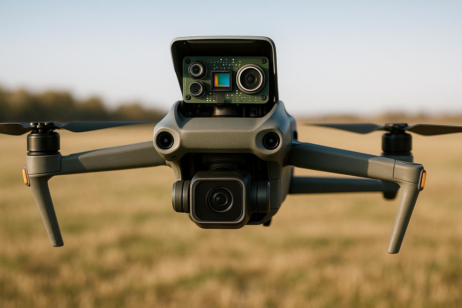
How to calibrate the vision sensors on the DJI M300 drone?
Preparation for Drone Sensor Calibration
Proper preparation is the key to avoiding calibration errors and ensuring accurate results during industrial inspections. Skipping critical steps can lead to unreliable data, unstable flight performance, and poor image quality. By following these guidelines, you’ll help maintain the sensor accuracy needed for advanced inspection tools like those from Anvil Labs.
Required Tools and Initial Checks
Before diving into calibration, make sure you’ve got everything you need. Gather these essentials:
- Fully charged batteries
- Your drone’s companion app or controller
- A laptop or mobile device with the necessary calibration software
Set up on a stable, level surface that’s free from vibrations and interference. Next, inspect your drone thoroughly. Look for any signs of damage, clean the sensor housings and camera lenses, and ensure all parts are securely attached.
Make sure your firmware is up to date, and allow your drone to reach room temperature for optimal sensor performance. Finally, check the calibration area for potential sources of magnetic or electronic interference - avoid locations near metal structures, power lines, or other electronics that could disrupt the process.
Once you’ve completed these checks, keep an eye on your drone for any signs that recalibration might be necessary.
When to Recalibrate
Certain situations call for recalibration to maintain sensor accuracy. These include:
- Firmware updates: New software can affect sensor settings, making recalibration essential.
- Physical impacts: Crashes, hard landings, or even bumps during transport can shift internal components, even if external damage isn’t visible.
- Geographic relocation: Moving to a region with different magnetic properties often requires compass recalibration, especially if inspections span diverse environments.
Watch for signs of calibration issues during flight. Symptoms like drifting while hovering, inconsistent headings, or unusual vibrations often point to problems that need immediate attention.
Even if no issues are apparent, periodic recalibration is a smart practice. For platforms like Anvil Labs, routine recalibration ensures precise 3D modeling and spatial analysis, supporting accurate and reliable operations.
Step-by-Step Guide to Calibrating Drone Sensors
Now that your preparations are complete, it’s time to calibrate each sensor system. Proper calibration ensures your drone delivers precise data, which is critical for professional industrial inspections. Here’s how to do it step by step:
IMU Calibration
The Inertial Measurement Unit (IMU) plays a key role in your drone's navigation by blending data from accelerometers, gyroscopes, and magnetometers. Correct calibration reduces drift and keeps your drone stable during flights.
- Start by placing the drone on a flat, stable surface that’s vibration-free.
- Power up the drone and its controller, then open the calibration menu in the companion app (usually under "Settings" or "Calibration").
- Follow the app’s prompts to position the drone on its six sides - front, back, left, right, top, and bottom. Make sure the drone stays completely still for each position.
- Wait for the app to confirm each step is complete before moving on.
- Once finished, restart the drone and perform a pre-flight check to ensure the sensors are responding as expected.
For advanced reliability, professional-grade drones often use techniques like sensor bias correction and temperature compensation.
Compass Calibration
Calibrating the compass is essential for accurate directional data, which helps maintain flight paths and create precise maps.
- Choose an open area free from metal objects, power lines, or anything that could cause electromagnetic interference.
- Access the compass calibration option in the drone’s app, typically located in the same calibration menu as the IMU settings.
- Rotate the drone horizontally in a full 360-degree circle, keeping it level and moving slowly.
- Next, rotate the drone vertically, completing a 360-degree turn around its vertical axis.
- Wait for the app to confirm the calibration is successful before proceeding.
Once the compass is calibrated, move on to the gimbal and accelerometer for further fine-tuning.
Gimbal and Accelerometer Calibration
For smooth footage and reliable orientation data, calibrating the gimbal and accelerometer is a must.
- Set up the drone as you did for the IMU calibration, ensuring the surface is stable and level. Also, check that the gimbal is securely attached.
- Navigate to the gimbal calibration option in the drone’s app, usually found in the camera or gimbal settings.
- Start the auto-calibration process. The gimbal will move through its full range of motion to align its motors and sensors. Avoid touching or moving the drone while this is happening.
- After calibration, test the gimbal’s movement using the app controls. If you notice any jerky or uneven motion, repeat the process.
Payload Sensor Calibration
Once the flight-critical sensors are calibrated, it’s time to focus on payload-specific sensors like thermal cameras and LiDAR. These require their own tailored calibration steps to ensure accurate data collection.
For thermal cameras:
- Ensure the lens is clean and the lighting is consistent.
- Calibrate using temperature reference sources. Point the camera at targets with verified temperature values.
- Use ambient temperature sources with known readings for further adjustments.
For LiDAR sensors:
- Set up flat, reflective surfaces at carefully measured distances to serve as spatial targets.
- The system will use these known distances to fine-tune its internal parameters.
Camera calibration can also be done using checkerboard or 3D pattern-based methods, supported by photogrammetry tools like Agisoft Metashape, Pix4D, and OpenCV.
Before calibrating payload sensors, make sure your drone’s firmware is up to date. After calibration, capture test data in controlled conditions and compare it to known reference standards to verify accuracy. This step is especially important when integrating the data with platforms like Anvil Labs.
sbb-itb-ac6e058
Troubleshooting Calibration Issues
Even with careful preparation, calibration problems can still arise. Knowing how to identify and fix these issues quickly is key to keeping your drone operational and ensuring it delivers dependable data for industrial inspections.
Common Calibration Errors
Failed calibration attempts often happen in areas with electromagnetic interference, on unstable surfaces, or when the battery is low. Calibration needs stable conditions and enough power to complete properly.
Sensor drift is another issue that can develop over time. This occurs when the drone starts to deviate from its intended position or orientation, leading to erratic flight behavior. Causes can include temperature changes, rough landings, or aging sensors. Longer flights may make this drift more noticeable as the drone gradually strays off course.
Inaccurate readings can stem from improper calibration procedures or environmental factors. For example, if the drone struggles to maintain altitude or the camera footage appears tilted during level flight, there could be issues with the IMU or gimbal calibration. Similarly, compass calibration errors might explain GPS discrepancies or unexpected veering during autonomous flights.
Unstable flight behavior - like sudden yaw movements, difficulty holding position, or sluggish response to controls - suggests that sensor data isn't being correctly relayed to the flight controller.
Environmental factors often play a role in these issues, but they can usually be resolved with some straightforward steps.
Practical Solutions
When calibration fails, start with simple fixes. Restart the drone and controller to clear any software glitches that might be causing the problem.
Choose the right location. If issues persist, move to an open outdoor area far from vehicles, buildings, power lines, or other sources of interference.
Set the drone on a stable, level surface for calibration. A solid base, like a concrete pad, works better than uneven or soft ground that might shift or vibrate.
Let the drone adjust to its surroundings before calibrating. If it’s been sitting in a cold car or under intense sunlight, give it time to reach the ambient temperature.
Check the battery level. A fully charged battery is essential for a smooth calibration process. Low power can disrupt calibration or lead to unreliable results.
Keep firmware up to date. Firmware updates can change calibration parameters, so always recalibrate after installing updates. Outdated firmware may not support new algorithms or could have bugs that affect sensor accuracy.
If none of these steps work, consider a full system reset following the manufacturer’s guidelines. This restores the drone to factory settings and can resolve persistent problems.
Clean sensors and camera lenses. Dust, moisture, or debris on sensor surfaces can cause distorted readings, even if the calibration process appears to have succeeded.
For industrial applications where precision is non-negotiable, document your calibration process and conditions. Note the location, weather, and any challenges you encountered. This record can help identify recurring issues and improve future calibration efforts.
When working with platforms like Anvil Labs for 3D modeling or spatial analysis, proper calibration becomes even more critical. Faulty sensor data can compromise the accuracy of 3D models, thermal images, or LiDAR scans, potentially disrupting the entire inspection workflow. Keeping sensors calibrated ensures your data integrates seamlessly with advanced tools like Anvil Labs, delivering reliable results for complex industrial tasks.
Maintaining Data Accuracy and Integration with Advanced Platforms
Keeping sensor data accurate is a continuous effort, especially in industrial inspection operations. Regular calibration ensures your data remains consistent and reliable while integrating it with advanced platforms enhances asset management and decision-making. Together, these practices form the backbone of effective inspection workflows.
Calibration as a Routine Practice
Routine calibration shifts the focus from fixing problems after they occur to preventing them in the first place. For instance, weekly calibration protocols have been shown to significantly reduce false positives and improve maintenance efficiency in practical applications.
Before each flight, it’s essential to perform checks like verifying sensor functionality, GPS signal strength, firmware updates, and physical condition. These pre-flight routines help catch potential issues early, ensuring your data collection remains accurate and dependable.
Allowing sensors to adjust to ambient conditions also minimizes environmental effects on calibration. Following best practices, regular calibration can cut data errors by up to 30% in industrial drone inspections. This improvement leads to more dependable asset assessments, better maintenance planning, and fewer false alarms. The time spent calibrating pays off quickly by boosting confidence in inspection results and reducing unnecessary interventions.
Modern drones often feature automated calibration routines, which can reduce pre-flight prep time by 15-20%, streamlining operations for inspection teams. However, automation doesn’t mean you can skip human oversight. Operators should always confirm that calibration is complete and understand the purpose of each sensor check.
Integration with Anvil Labs
Once your calibration practices are solid, integrating accurate data into platforms like Anvil Labs becomes seamless. Properly calibrated data is essential for leveraging the advanced capabilities of platforms that handle various data types, including 3D models, 360° imagery, thermal scans, LiDAR, and orthomosaics.
When you upload calibrated data - such as LiDAR point clouds or thermal imagery - Anvil Labs can process it for precise measurements and maintenance planning. This ensures repairs are prioritized based on reliable data, minimizing downtime and avoiding unexpected failures.
The platform’s tools for measurement and annotation shine when paired with accurate input data. Precise spatial accuracy allows for meaningful comparisons between inspections, making it easier to identify trends and plan proactive maintenance. Without proper calibration, even the most advanced tools could produce misleading results, potentially causing missed issues or unnecessary repairs.
Anvil Labs users have reported impressive results: inspections completed 75% faster, 30% more defects detected, and savings in the range of hundreds of thousands of dollars compared to traditional methods. However, these benefits hinge on the quality of the input data - poor calibration can compromise the entire analysis process.
"My overall experience with the software has been satisfying because of the efficient workflow. I would highly recommend other organizations to use your software simply because of how much value you get for what you pay for... The ROI is clearly marked within the first few uses." - Angel Rojas, Red Angel Drones
Anvil Labs also supports seamless integration with enterprise systems through cross-device accessibility and API connections. This ensures data flows smoothly while maintaining traceability. Every dataset can be linked to specific calibration events, inspection dates, and asset conditions, which is invaluable for regulatory compliance and quality assurance.
Platforms like Anvil Labs are leveraging AI and machine learning to analyze drone inspection data more effectively, from detecting anomalies to enabling predictive maintenance. But these advanced features only work as intended when the input data is accurate. Poorly calibrated data can mislead machine learning algorithms, resulting in unreliable predictions.
To make the most of integration, ensure your data includes standardized formats and detailed calibration logs. Metadata - such as calibration dates, environmental conditions, and any challenges during data collection - helps the platform process your data more effectively and provides valuable context for future analyses.
Finally, security is critical when dealing with sensitive inspection data. Anvil Labs offers secure data-sharing features with access controls, but organizations should also maintain thorough documentation. Keep records of who performed calibrations, when data was collected, and how it’s being used throughout the asset management process. This level of oversight supports both security and operational transparency.
Conclusion
Calibrating your drone's sensors isn't just a technical step - it's the foundation for accurate, safe, and efficient inspections. From the IMU and compass to the gimbal and payload sensors, each component plays a key role in capturing reliable data that meets industry standards and regulatory requirements.
Making calibration a routine part of your operations offers real advantages. It helps reduce costs, improves inspection accuracy, and ensures smoother workflows. Whether it's before a mission, after a firmware update, or when environmental conditions change, regular recalibration helps prevent errors and keeps your data precise and dependable. This approach also ensures compliance with regulations and supports quality assurance efforts.
Beyond the basics, combining well-calibrated drone data with advanced tools like Anvil Labs can take your operations to the next level. When accurate sensor data integrates seamlessly with asset management systems, teams gain access to powerful tools for measurement, annotation, and collaborative analysis. This not only streamlines maintenance planning but also cuts down on unnecessary site visits and enables smarter decision-making across the board.
Calibration impacts every stage of your inspection workflow. Factors like sensor fusion techniques and environmental conditions during setup can directly affect the reliability of your results. Treating calibration as a core operational practice, rather than an afterthought, ensures consistent, high-quality outcomes that deliver measurable business benefits.
Investing time in proper calibration pays off in many ways - stronger data integrity, improved safety, and the ability to fully utilize the advanced analysis tools that modern industrial inspections demand.
FAQs
Why is regular drone sensor calibration important, and what can happen if it’s neglected?
Regularly calibrating your drone’s sensors is key to collecting precise data, especially during industrial inspections where accuracy matters most. Whether you're using thermal cameras, LiDAR, or other advanced tools, keeping your sensors calibrated ensures dependable measurements.
Skipping calibration can lead to flawed readings, poor data quality, and mistakes in analysis. These errors could translate into expensive missteps, unreliable conclusions, or even safety hazards during operations. To steer clear of these risks, make sensor calibration a regular part of your drone maintenance routine.
How can I tell if my drone sensors need recalibration?
If your drone starts acting up - like drifting, tilting, or having trouble holding a steady hover - it might be time to recalibrate its sensors. Other warning signs include incorrect altitude readings, inconsistent GPS positioning, or odd behavior during automated flights. These issues often point to misaligned or out-of-tune sensors.
It’s a good idea to recalibrate regularly, especially after events like firmware updates, rough landings, or long trips where the drone may have been jostled. Properly calibrated sensors ensure accurate data and smooth, reliable flight performance.
What steps should I follow to successfully calibrate drone sensors and avoid common mistakes?
To properly calibrate your drone's sensors, start by carefully reading the manufacturer's instructions specific to your drone model. These guidelines are designed to provide detailed, step-by-step directions tailored to your equipment. Choose a stable environment for calibration - steer clear of areas with strong magnetic fields, extreme temperatures, or uneven ground.
Before you begin, make sure your drone's firmware is updated and the battery is fully charged. During the calibration process, take your time and follow each step precisely - rushing can lead to errors. If your drone relies on multiple sensors like GPS, IMU, or a compass, calibrate them in the order recommended by the manufacturer to avoid conflicts.
Once calibration is complete, perform a brief test flight to confirm that all sensors are working as expected. If problems persist, you may need to repeat the process or reach out to the manufacturer's support team. Proper calibration is key to ensuring your drone collects accurate data, which is especially important for tasks like industrial inspections or spatial analysis.
