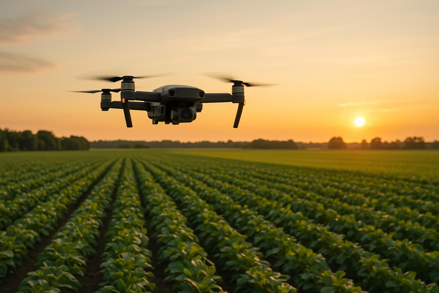
Drone-based yield mapping changes how farmers manage crops. Using drones equipped with advanced sensors, farmers can gather high-resolution data across large fields - up to 1,000 acres daily. This data helps identify crop health issues, optimize resources, and improve yields. For example, one farmer in Idaho saved $60,000 by catching an aphid infestation early using a drone.
Key takeaways include:
- Regulations: FAA Part 107 certification is required for commercial use, and drones over 0.55 lbs must be registered.
- Flight Planning: Use software to set efficient routes, maintain 75% image overlap, and fly between 10:00 a.m. and 2:00 p.m. for best lighting.
- Equipment: Choose drones and sensors based on goals. Multispectral sensors are ideal for crop health, while thermal cameras help monitor irrigation.
- Data Accuracy: Use Ground Control Points (GCPs) to improve mapping precision.
- Analysis: Generate NDVI maps to monitor plant health and combine drone data with historical records for better decisions.
This approach improves yields by up to 30% while reducing input costs by 15%. Farmers can also save $25 per acre on seeds and fertilizers. By integrating drone data into farm management, you can make more informed decisions and boost profitability.
How to Map High-Value Crops with Drones
Pre-Flight Planning and Compliance
Planning ahead is the backbone of successful drone yield mapping. By understanding the rules, plotting your flight path, and keeping an eye on the weather, you can ensure smooth operations and get the best possible data.
Understanding FAA Regulations

In the U.S., the FAA oversees all airspace - even the skies above your farmland. This means every agricultural drone operation must follow federal aviation rules, regardless of whether the flight is over private property.
If you're flying drones for business purposes, like yield mapping, you'll need FAA Part 107 certification. Recreational pilots, on the other hand, are required to have the FAA TRUST Certificate. To get the Remote Pilot Certificate necessary for yield mapping, you'll need to pass the FAA Aeronautical Knowledge Test, which covers airspace rules, weather conditions, and flight operations.
Don't forget about drone registration - it’s mandatory for any drone weighing more than 0.55 pounds and is valid for three years. Additionally, the FAA now requires most drones to comply with Remote ID rules. This means your drone must broadcast its identification and location during flight to help maintain airspace safety.
If you're planning to use drones for spraying chemicals or agricultural products, you'll need extra certification under FAA Part 137. This includes obtaining an Agricultural Aircraft Operator Certificate, and in many cases, you’ll also need a state-level chemical applicator license.
Flight Path Planning
Using flight planning software is key to collecting precise data. These tools allow you to pre-program waypoints, define coverage areas, and create efficient routes that cut down on flight time and battery usage.
To maximize efficiency, focus on coverage path planning. For example, a study on sugarcane fields found that targeting only weed-infested areas reduced coverage time by 66.3% compared to traditional scanning methods. Adjust your flight settings - like altitude, speed, and pattern type - to match the shape of your field. Rectangular fields often work well with grid patterns, while irregular fields might require custom waypoints. Many tools also offer terrain-following modes to keep a consistent height above ground, even on uneven landscapes.
Image overlap is another critical factor. Plan for at least 75% overlap in both forward and side directions to ensure mapping software can stitch the images together accurately.
Safety features like geofencing and failsafe logic are also essential. Geofencing keeps your drone within designated boundaries, avoiding restricted airspace. Meanwhile, return-to-home functions can automatically bring your drone back if it loses signal or runs low on battery.
With careful planning, agricultural drones can survey up to 1,000 acres in a single day. Many modern drones also come equipped with multispectral sensors, enabling detailed crop health analysis. This level of efficiency comes from smart route optimization - not just flying faster.
Once your flight path is set, align your schedule with favorable weather conditions to maintain high-quality data.
Weather and Timing Requirements
Weather plays a significant role in the success of your yield mapping efforts. Poor conditions can ruin a flight, while good timing ensures clear, actionable insights.
For the best multispectral imagery, fly between 10:00 a.m. and 2:00 p.m. During these hours, the sun’s position reduces shadows that could obscure crop details or interfere with vegetation index calculations. Early morning or late evening flights, by contrast, often lead to long shadows that distort data.
Sky conditions are another key factor. Aim for either completely clear skies or uniform overcast. Partly cloudy days can cause uneven lighting as clouds move, making it harder to assess crop health accurately.
Be mindful of hot, dry weather, as it can cause plants to roll their leaves as a protective measure. This can create false indicators of crop stress that don’t reflect actual health or yield potential. Other environmental factors - like wind speed, solar radiation, and air temperature - can also affect thermal sensor readings, especially when monitoring irrigation or heat stress.
Seasonal timing is equally important. For yield prediction, fly during key growth stages when differences between crops are most pronounced. For harvest planning, collect data closer to maturity when variations in yield are fully developed. Scheduling multiple flights throughout the growing season provides a more complete picture, allowing for accurate comparisons over time.
Drone and Sensor Selection
Before diving into drone and sensor options, it’s essential to define your yield mapping goals. Are you focusing on crop health, identifying nutrient deficiencies, or monitoring irrigation? Your objective will guide you in choosing the right drone and sensors. For instance, fixed-wing drones are ideal for large fields, while rotary-wing drones work better for smaller or irregularly shaped areas. Key factors like battery life and positional accuracy also play a crucial role, ensuring your drone can cover the required acreage without frequent interruptions. Once you’ve chosen a platform, it’s time to delve into sensor types, calibration, and maintenance practices to ensure the data you collect is reliable.
Sensor Types and Uses
Multispectral sensors dominate the agricultural drone space, with over 80% of drones using them for precise crop health analysis. These sensors capture data across specific spectral bands, revealing plant health and physiological details that are invisible to the human eye.
RGB cameras are a simpler, cost-effective option. They provide general field imagery and can still predict several crop characteristics, making them a versatile choice for yield mapping.
Thermal cameras specialize in detecting water stress and monitoring irrigation. They help identify moisture-related issues like pests and diseases and provide insights into water usage. For example, thermal imaging can pinpoint stress areas in a field that often align with yield variations.
A notable example of sensor optimization is the Sentera Double 4K system paired with the Mavic 3 Enterprise. This setup captures images at a rapid rate of two frames per second, making it an excellent choice for surveying large areas quickly.
Cooled thermal cameras offer unmatched sensitivity and accuracy but come with trade-offs - they’re bulky, expensive, and drain power quickly, which limits their practicality for smaller drones. On the other hand, uncooled thermal cameras are lighter and more energy-efficient. However, they require careful calibration to ensure accuracy.
Sensor Calibration and Maintenance
Calibration is the key to turning raw sensor data into actionable insights. Without it, even the most advanced sensors can produce misleading results. For example, a study at Texas A&M AgriLife research farm showed that using temperature-controlled references reduced errors caused by ambient conditions from 48.7°F (9.29°C) to 35.0°F (1.68°C). Similarly, crop temperature estimation errors dropped from 57.2°F (14.0°C) to 33.8°F (1.01°C) with proper calibration.
Field-based calibration, such as using temperature-controlled panels before flights, delivers the most reliable results by compensating for environmental variations. Advanced neural network–based calibration methods further enhance accuracy, improving measurement precision from 6.4°F (3.55°C) to 2.5°F (1.37°C) in one study. For multispectral sensors, using reference panels and ambient radiance sensors ensures consistent and accurate measurements, even under changing sunlight conditions.
Regular maintenance is equally important. Clean sensor lenses before every flight, check for physical damage, verify calibration settings, and store sensors in protective cases to shield them from extreme temperatures.
Battery Life and Storage Requirements
A drone’s battery life directly impacts how much ground it can cover in a single flight. Most agricultural drones currently offer 20–30 minutes of flight time, though this depends on factors like payload weight, weather conditions, and flight patterns. Advances in solid-state battery technology could soon extend flight times from 25 minutes to as much as 80 minutes, enabling drones to map up to 125 acres in one session. Some farmers have already seen efficiency gains of 20–30% thanks to improved battery performance, with future expectations pointing to flight durations of 60–90 minutes per charge.
However, environmental factors like extreme temperatures, strong winds, and high altitudes can reduce battery capacity. For instance, the British Antarctic Survey demonstrated that drones equipped with LTO batteries could achieve 45-minute flights even in temperatures as low as –50°F.
To maximize efficiency, balance your drone’s payload with its battery capacity. Smart systems, like those in XAG agricultural drones, use real-time data and AI-driven flight optimization to improve efficiency by up to 40%. Efficient flight planning also makes a difference. Break large fields into manageable segments that fit within your drone’s flight time, and use predictive flight planning tools to chart the most efficient routes. Real-time monitoring systems can further optimize coverage by tracking energy consumption during flights.
Finally, proper battery care is essential for longevity. Store batteries in cool, dry places, avoid overcharging or deep discharging, and conduct regular inspections to ensure they’re in good condition. High-capacity storage solutions are equally important for managing the large volumes of high-resolution imagery collected during flights. Investing in reliable storage systems ensures your data remains secure and accessible for analysis.
Data Collection Methods
Accurate yield mapping hinges on consistent, high-quality geospatial data. A critical step in achieving this is the proper setup of Ground Control Points (GCPs), which play a key role in improving mapping accuracy. Let’s dive into the essentials of deploying GCPs effectively to ensure precise mapping results.
Ground Control Points Setup
In geospatial data collection, the correct implementation of GCPs is non-negotiable. These points drastically enhance mapping accuracy, reducing positional errors. Without them, drone positions can deviate by as much as 16 feet horizontally and 65 feet vertically.
The number of GCPs you’ll need depends on factors like field size and flight configuration. For example, Aerotas suggests using 5 GCPs per flight battery, while RTK-enabled aircraft typically require at least 3 GCPs for reliable results. For a 20-acre field, plan to set up 5–7 GCPs. Place them strategically - at each corner of the field (about 50 feet inset from the boundaries) and include additional points in the center or at areas with significant elevation changes to minimize mapping distortions like doming. Avoid aligning GCPs in a straight line to maintain strong geometric control.
Each GCP should be at least 10 times the size of your Ground Sampling Distance (GSD). In most agricultural mapping scenarios, this translates to approximately 28 inches by 28 inches. Patterns like chessboards or triangles work well, as they are easy to spot from aerial imagery.
For accurate GCP positioning, use RTK or PPK-enabled GNSS receivers. Consumer-grade GPS devices often lack the precision required for this task. Additionally, ensure every GCP is clearly visible from the air and securely anchored to prevent movement during flights. These details make all the difference in achieving reliable, high-quality geospatial data.
Data Processing and Analysis
Once you've gathered drone imagery with properly set ground control points, the next step is turning those raw images into detailed yield maps.
Image Processing and 3D Model Creation
To start, transform raw drone images into orthomosaics and 3D point clouds using specialized processing software. These tools automatically align and stitch overlapping images, creating accurate spatial relationships. The result? Detailed 3D models that highlight elevation changes, drainage patterns, and other field features critical for precision agriculture.
When choosing a processing platform, consider your specific needs. Desktop software offers more control over parameters, while cloud-based services make sharing results easier. The choice of platform plays a big role in the level of detail you can extract.
Georeferencing is another essential step. By using ground control points, you can align your maps with GPS coordinates, ensuring they match up with GPS-guided equipment and field boundaries. This precision is vital for integrating your drone data into broader farm management systems.
Finally, processed imagery can be analyzed further to generate vegetation indices, offering valuable insights into crop health.
Vegetation Index Analysis
Using processed imagery, vegetation indices turn drone data into actionable crop health metrics. The Normalized Difference Vegetation Index (NDVI) is widely used, as it compares near-infrared and red light bands to assess plant health. High NDVI values signal healthy, dense vegetation, while low values may indicate stress, drought, or sparse growth. It’s no wonder that over 80% of agricultural drones rely on multispectral sensors for accurate crop health analysis.
Regular NDVI monitoring throughout the growing season establishes baseline health metrics and helps detect issues like nutrient deficiencies, pests, or diseases early. This can also guide irrigation adjustments. However, NDVI has its limitations - when using standard RGB data or in areas with sparse vegetation, its effectiveness drops. For crops like rice, alternative indices like the Normalized Green-Red Difference Index (NGRDI) often perform better, especially for spotting weeds that can cause yield losses of 45–95%. Investing in high-resolution NDVI sensors and maintaining optimal flight altitudes can also improve the accuracy of yield predictions.
Data Integration Methods
To get the most out of your drone data, combine it with historical yields, soil maps, climate data, irrigation details, and crop management records. Integration platforms can merge this information with real-time weather and soil sensor data. For example, correlating NDVI readings with soil moisture and weather patterns can help distinguish between temporary stress caused by recent weather and long-term issues that require immediate intervention.
Case studies illustrate the power of integrated data. In one California vineyard, drones equipped with NDVI sensors helped monitor vine health with precision, leading to better grape quality and higher yields. Similarly, an avocado orchard successfully paired thermal imaging with NDVI analysis to fine-tune irrigation schedules, cutting water use while maintaining fruit quality and yield.
AI tools can also be a game-changer. They analyze trends and detect anomalies across multiple seasons, helping you refine your strategies year over year. To keep your data organized, tag it consistently by project, location, and date. This is especially important given that agricultural drones can cover up to 1,000 acres in a single day. By incorporating lessons from each mission, you can continuously improve your data collection and processing methods, maximizing the value of drone technology in your operations.
sbb-itb-ac6e058
Data Management and Sharing
Organizing drone yield data is critical for turning raw information into actionable farming decisions. Once your data is processed, proper storage and seamless sharing ensure those insights can be effectively applied in the field.
Data Storage and Backup
Managing terabytes of drone imagery becomes much easier with cloud storage. Unlike local storage, cloud platforms offer features like automatic backups, version control, and access from multiple devices, making them an ideal choice for handling large datasets.
For better organization, adopt a consistent file naming system, such as Field_A_NDVI_08032025. Pair this with automated backup schedules to safeguard your data. Storing backup copies in geographically distinct locations adds an extra layer of protection against risks like hardware failures, accidental deletions, or natural disasters.
Establish clear data retention policies. While recent data is essential for immediate decisions, keeping historical records spanning several years can help uncover long-term trends and guide strategic planning.
Using Anvil Labs for Data Management

Anvil Labs is a powerful tool for managing drone data, streamlining everything from uploads to client delivery. It handles orthomosaics, 3D models, and thermal imagery while offering secure sharing options that go beyond traditional file storage solutions.
Users have reported noticeable time savings and improved efficiency. Connor Barnes from Leading Edge Environmental and Emergency Services shared his experience:
"I had a meeting yesterday with my clients and they really liked the panoramas. I appreciate all the cool tech you've got here. This saves me from DroneDeploy! The per project pricing makes it easy for me to bill customers. It's too arbitrary to predict the cost to customer with Agisoft or Pix4D's cloud costs."
The platform also includes annotation and measurement tools, allowing users to pinpoint and highlight specific areas of concern directly on mapped imagery. Its cross-device compatibility means stakeholders can access and interact with yield maps on smartphones, tablets, or computers - no specialized software required - enabling faster decision-making in the field.
With robust sharing controls, you can set different access levels for various stakeholders, ensuring that everyone gets the information they need without compromising sensitive data.
Map and Report Creation
Once your data is well-organized, creating actionable maps and reports becomes straightforward. Effective yield maps should use color-coded zones to highlight problem areas, with contrasting colors clearly indicating sections needing immediate attention versus those performing well.
Consistency is key - use the same color schemes and symbols for indicators like NDVI values or elevation changes across all reports. This helps farm managers quickly interpret data when comparing fields or tracking changes over time.
Go beyond general observations by including zone-specific recommendations in your reports. For example, suggest precise actions like applying a specific nutrient rate or improving drainage. This transforms raw data into practical advice.
Incorporate historical data for added insight. Side-by-side comparisons of current and past conditions can reveal recurring issues or temporary changes due to factors like weather.
To maximize usability, export maps in multiple formats. PDFs are great for sharing with consultants or lenders, while GeoTIFF files integrate seamlessly with precision agriculture tools. Always time-stamp reports and include metadata - such as weather conditions, altitude, and sensor settings - to provide context and validate the data’s accuracy. This attention to detail ensures your reports are both reliable and actionable.
Key Takeaways
Drone-based yield mapping takes the guesswork out of farming, replacing it with evidence-driven strategies that improve both profitability and resource efficiency. By combining careful planning, high-quality data collection, and smart management, farmers can create a system that significantly boosts their farm's performance. These methods lead to noticeable gains in crop yield and better use of resources.
The results speak for themselves. Precision farming with drones can increase crop yields by up to 30% while cutting water usage by as much as 40%. For instance, a cotton farmer in Texas used drones to fine-tune pest management, cutting pesticide use by 30% and increasing yields by 12%. Similarly, a soy farmer in Brazil used UAV mapping to identify problem areas in the field, implementing recovery strategies that boosted yields by 20% the following season.
Drones offer quick, high-resolution insights into field conditions, empowering farmers with actionable data.
At the heart of this success is data-driven decision-making. By analyzing drone data throughout the growing season, farmers can make accurate yield forecasts, which help with harvest planning, market timing, and resource allocation. Take the example of an Iowa farmer who used drones and machine learning to improve corn yield predictions by 25%, ultimately increasing revenue by around $40,000.
To maximize these benefits, consider integrating drone data into your current practices. Invest in training to use tools like regression analysis and machine learning for refining yield predictions. Machine learning models, in particular, can enhance predictions by analyzing historical data, offering even greater precision.
Looking ahead, the future of drone mapping looks even brighter. Emerging trends like AI-powered automated analysis, lower technology costs making drones accessible to farms of all sizes, and edge computing for real-time field recommendations are set to take this technology to the next level. As sustainable farming practices grow in importance, drones are playing a vital role in promoting eco-friendly initiatives and improving agricultural efficiency.
When integrated into a precision agriculture strategy, drone mapping becomes a powerful tool for boosting both sustainability and profitability. By combining drone data with platforms like Anvil Labs for effective data management and sharing, farmers can turn raw field data into actionable insights. This holistic approach ties together earlier steps like flight planning, sensor selection, and data analysis, completing the yield mapping process and driving better outcomes for farms.
FAQs
What are the advantages of using multispectral sensors for drone-based yield mapping?
The Role of Multispectral Sensors in Drone-Based Yield Mapping
Multispectral sensors bring a distinct edge to drone-based yield mapping by capturing light data across a range of wavelengths, including those invisible to the human eye. This capability provides a deeper look into crop health, helping to detect early indicators of issues like nutrient deficiencies, pest problems, or disease outbreaks.
By delivering accurate insights into vegetation health and stress levels, multispectral imaging plays a key role in precision agriculture. This technology empowers farmers to make well-informed, targeted decisions that can boost crop yields, cut down on wasted resources, and enhance overall efficiency and profitability.
What steps should farmers take to comply with FAA regulations when using drones for agriculture?
FAA Regulations for Agricultural Drone Use
If you're a farmer using drones for agricultural purposes, it's important to stay compliant with FAA regulations. For starters, any drone weighing 0.55 pounds or more must be registered. Additionally, drone operators need to obtain a Part 107 Remote Pilot Certificate, which involves passing a knowledge test. For tasks like spraying crops, you might also need an FAA Part 137 Agricultural Aircraft Operator Certificate.
Farmers must also adhere to Remote ID requirements, ensuring their drones can be identified while in the air. Other key rules include keeping drones within your visual line of sight, avoiding flights over people or restricted areas, and following local airspace guidelines. Staying up to date on FAA rule changes is critical for staying compliant.
What are the best practices for ensuring accurate and reliable drone data for yield mapping?
To get the most accurate and dependable drone data for yield mapping, start with careful pre-flight checks. Make sure all sensors, cameras, and equipment are working as they should. Check battery levels, confirm GPS connectivity, and review weather conditions to avoid disruptions.
Leverage high-precision positioning systems to achieve centimeter-level accuracy - this level of detail is crucial for creating precise maps. Don’t forget to regularly calibrate your sensors and GPS systems to keep performance consistent and minimize errors.
Once your data is collected, focus on thorough validation and processing. Look for any anomalies, fix errors, and align your data with field boundaries or other reference points. By sticking to these practices, you’ll ensure your drone-based yield mapping is as effective as possible, helping you make smarter decisions for your crops.
