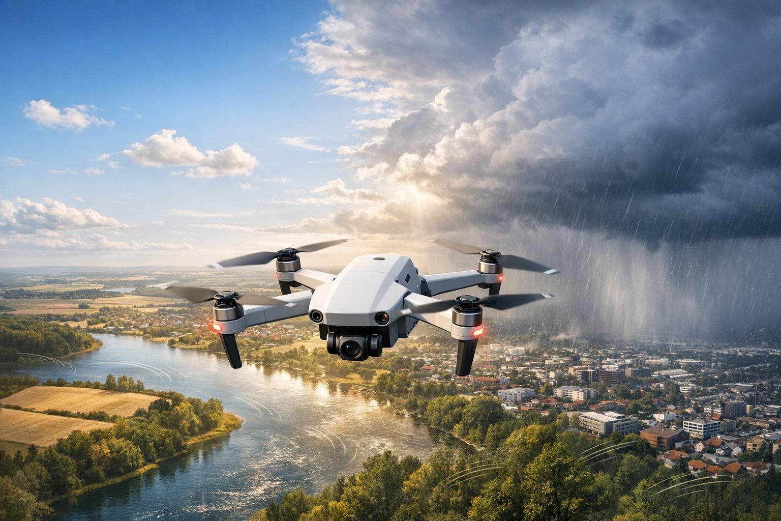
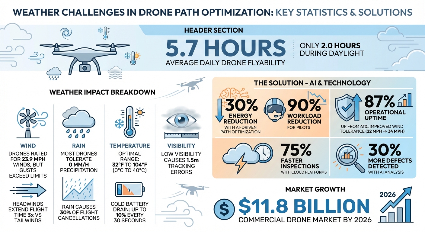
Weather is the single biggest factor limiting drone operations. Most drones can only fly about 5.7 hours daily due to wind, rain, temperature extremes, and visibility issues. These challenges disrupt industries like emergency response and infrastructure repair, where delays can be costly.
Key takeaways:
- Wind: Sudden gusts and turbulence drain batteries and destabilize drones.
- Rain: Damages sensors and electronics, making most drones unusable in precipitation.
- Temperature: Cold reduces battery life; heat strains electronics.
- Visibility: Fog and heavy rain hinder navigation and data collection.
AI and real-time weather data are helping drones adjust flight paths, conserve energy, and stay safer in tough conditions. For example, tools like WindSeer predict turbulence, while cloud platforms combine weather data with flight analytics to improve planning. These advancements are critical as the commercial drone market grows to $11.8 billion by 2026.
Weather Impact on Drone Operations: Key Statistics and Solutions
Towards Real-Time Motion Planning in Windy Urban Environments - Spencer Folk, PhD Candidate, UPenn

sbb-itb-ac6e058
High Winds: A Major Challenge for Stable Drone Flights
Drones are often rated to handle winds up to 23.9 mph, but in practice, gusts and crosswinds can easily exceed these limits, especially during critical data collection missions.
How Wind Affects Drone Operations
Wind presents unique challenges for drone operations, requiring careful planning and adjustments. A study conducted in July 2017 at Saguache River Canyon highlighted how turbulence in specific flight path segments led to excessive battery drain in drones equipped with 5,870 mAh LiPo batteries. In mountainous areas, where winds often exceed 22 mph (about 10 m/s) - a speed that matches the cruising capability of many small drones - drones can become nearly impossible to recover if wind speeds surpass their operational capacity. The research also found that headwinds can extend flight times by up to three times compared to tailwind-assisted return legs.
Crosswinds create another layer of difficulty by forcing constant lateral corrections, which compromises flight stability. This is especially problematic for mapping and imaging tasks, as even small deviations from the planned path can lead to missing images or misaligned sensor data. Meanwhile, gusts demand rapid corrective maneuvers, which can result in blurry LiDAR data and orientation errors in the Inertial Measurement Unit (IMU), ultimately degrading data quality.
The table below summarizes the specific effects of different wind types:
| Wind Type | Primary Impact | Specific Consequence |
|---|---|---|
| Headwind | Reduced ground speed / Increased drag | Risk of aircraft loss in mountainous terrain |
| Crosswind | Lateral drift requiring constant correction | Reduced mapping accuracy; sensor misalignment |
| Gusts | Rapid attitude and position changes | Blurry LiDAR data; IMU errors; unstable imagery |
Most commercial drones are designed to handle winds up to 22 mph (10 m/s). However, increasing this limit to 33 mph (15 m/s) could significantly improve operational uptime, raising it from 41% to 87% in major population areas.
Methods for Reducing Wind Problems
Experienced drone pilots often account for wind variability by adding a 30% safety margin to the manufacturer’s wind ratings. Advanced technology is also stepping in to tackle wind challenges. For instance, WindSeer, an AI model powered by convolutional neural networks, predicts wind conditions at a very fine scale using data from onboard sensors. Tests in the Swiss Alps demonstrated its ability to forecast vertical wind changes with a 120-second lead time.
NASA has also contributed to this field by applying reinforcement learning and Markov Decision Process models to optimize flight paths. These approaches help drones balance energy use and mission safety under fluctuating wind conditions. By focusing on prediction rather than reaction, these AI-driven solutions enhance overall flight stability and complement pre-flight simulations designed to identify wind-prone areas.
On the practical side, simple adjustments can make a big difference. Flying sweeps perpendicular to the wind helps maintain a steady ground speed during data collection. Additionally, turning into the wind at the end of flight lines can improve efficiency. Some advanced drones are even programmed to trigger an earlier "Return to Home" command when headwinds demand too much power for a safe return.
Pre-flight simulations that factor in wind forecasts are a vital step in planning. Operators are advised to avoid takeoff if sustained ground winds exceed 19 mph (8 m/s) for more than 30 seconds. Maintaining at least 50 feet of distance from wind barriers, such as buildings, is also recommended to avoid turbulence during takeoff and landing.
Rain, Temperature Extremes, and Visibility: Additional Weather Problems
Rain, extreme temperatures, and low visibility can significantly impact a drone's performance and stability. These weather conditions affect various components of drone hardware and operations, making it essential for operators to understand the risks and prepare accordingly.
How Rain Impacts Sensors and Flight Durability
Most commercial drones are not built to handle any level of precipitation, with a typical tolerance of 0 mm/h. Rain can cause serious issues, such as short-circuiting motors, cameras, and infrared sensors, which increases the risk of crashes [15, 17].
"Rain can damage sensitive electronic components, such as motors, sensors, and cameras."
– Climavision
Rain also obstructs cameras and sensors, making it harder to maintain a clear view or collect accurate data. Water streaks can blur small details and reduce contrast, which disrupts visual odometry systems used for tracking and planning trajectories [16, 18]. For instance, research on the VINS-Fusion visual odometry system showed that rainy conditions could lead to an average tracking error of 1.5 meters in the worst-case scenario. In colder weather, rain can freeze on propellers, reducing their ability to generate lift and compromising flight safety.
Even minor improvements in weather resistance can significantly extend drone operation times. For example, increasing a drone's precipitation tolerance from 0 mm/h to just 1 mm/h can boost median flyability from 41% to 87% in major urban areas. To mitigate risks, operators should check their drone's Ingress Protection (IP) rating to ensure it provides adequate protection against water and dust. Before deployment, tools like high-resolution weather radar and Numerical Weather Prediction (NWP) models can help detect incoming rain. After exposure to rain, clearing water from cameras and infrared sensors and using shaded locations or display hoods can help manage glare and visibility problems.
Temperature Extremes and Battery Performance
Temperature swings present another set of challenges for drone operations. In cold weather, lithium batteries experience increased internal resistance below 59°F (15°C), which reduces their ability to discharge power and causes voltage drops. If the voltage of a battery cell drops below 3 V, the drone may struggle to maintain high speeds or maximum thrust, raising the risk of sudden power failure.
"Temperatures below 15°C (59°F) increase a battery's internal resistance, which leads to a decrease in its discharge capacity and an increase in voltage drop during discharge."
– DJI Enterprise
Cold weather can also accelerate battery drain, with depletion rates spiking from 1–2% to as much as 10% every 30 seconds. Additionally, cold temperatures can age gimbal damper rubber, solidify damping grease (causing shaky footage), and trigger flight control errors. For example, DJI Enterprise tested the Matrice 300 RTK in extreme cold by flying it continuously for 24 hours at –13°F (–25°C) to ensure reliability in sub-zero conditions.
Hot weather introduces different issues. High temperatures can cause batteries to discharge faster, reducing overall flight time. Heat can also damage sensitive electronics and affect flight stability [21, 4]. When combined with high humidity, excessive heat can harm batteries if they aren’t stored in climate-controlled environments. Most commercial drones are designed to operate between 32°F and 104°F (0°C to 40°C), while weather-resistant models can handle a range of –4°F to 115°F (–20°C to 46°C).
To address these challenges, operators can take steps like pre-warming batteries to at least 59°F (15°C) using preheaters or by powering them on early. Storing batteries in insulated cases can also help [19, 22]. After takeoff in cold weather, hovering for about a minute allows batteries and sensors to warm up. Swapping out batteries when they reach 30% capacity during cold flights can prevent sudden power loss. In hot conditions, keeping drones in shaded areas between flights, storing batteries in coolers, and limiting flight durations can reduce thermal stress [19, 20]. For fogged lenses caused by temperature shifts, preheating the drone can help dissipate moisture before takeoff.
Visibility Problems in Urban and Industrial Areas
Fog, haze, and low light create significant challenges for drone navigation and data collection, especially in complex urban or industrial settings. Poor visibility affects optical sensors and line-of-sight navigation. For example, cameras used in "sense and avoid" systems or high-resolution imaging can struggle with atmospheric interference and moisture or ice buildup.
Visual odometry systems, which many autonomous drones rely on for local tracking, can see an average tracking error of 1.5 meters in low-visibility conditions. Thermal data collection can also be affected, as reduced contrast between targets and their surroundings - caused by overlapping ambient temperatures or atmospheric interference - can lead to missed detections or false positives.
Fortunately, technology offers solutions to these issues. Thermal infrared sensors can detect targets based on heat signatures, even when visual contrast is poor [23, 24]. For instance, in 2015, researchers used senseFly eBee drones equipped with thermal infrared sensors to survey seal colonies in Canada. By analyzing thermal signatures and using automated GIS workflows, they achieved results closely matching those of human analysts.
AI-driven tools further enhance drone performance. Lightweight neural network models like MobileNetV3 small can classify environmental disturbances with 90% accuracy while maintaining 93 frames per second on standard drone hardware, using just 1.28 MB of memory. This allows real-time adjustments to navigation. For optimal thermal imaging, conducting missions at dawn maximizes the temperature difference between targets and their surroundings, minimizing interference from solar heating. In cases where optical sensors fail, Lidar sensors can provide precise distance measurements, even in low-light or haze-filled conditions. Integrating real-time weather data into flight planning helps drones adapt to these challenging visibility conditions.
AI-Driven Solutions for Adjusting Drone Paths in Bad Weather
Artificial intelligence is reshaping how drones navigate through challenging weather conditions. Instead of relying on fixed flight plans or manual intervention, AI-powered systems now process real-time weather data to automatically adjust drone routes, ensuring both safety and efficient battery use. By combining machine learning with physics-based models, these systems predict drone behavior with precision, paving the way for seamless integration of live weather data.
Real-Time Weather Data Integration
Modern AI platforms leverage localized weather forecasts to monitor winds, thermals, and turbulence at the specific altitudes drones operate. Traditional Numerical Weather Prediction (NWP) models, which work on a kilometer scale, lack the granularity needed for small drones. AI solutions like WindSeer address this gap by using deep neural networks to interpret sparse onboard wind data collected by the drone itself.
"If an sUAV knew the wind in advance, it would be able to plan its path so as to avoid areas of unfavorable winds and high turbulence."
– Nature Communications
Recent tests have shown that these models can predict low-altitude wind variations with impressive accuracy. AI systems continuously analyze live data to adjust flight paths, enabling drones to reroute, return to base, or land safely based on energy levels and risk assessments. This modular system allows operators to incorporate micro-weather adjustments into professional command systems. For instance, Shearwater's Smart Flight AI has been integrated with Lockheed Martin's VCSi C2 Software, enabling automated flight adjustments within military-grade control systems.
Energy-Efficient Path Planning
Using real-time weather insights, AI also optimizes drone flight paths to conserve battery life. These algorithms consider wind direction, speed, and turbulence to select the most energy-efficient routes. Advanced techniques like GA-LNS (Genetic Algorithm combined with Large-Scale Neighborhood Search) solve complex trajectory challenges by dynamically factoring in wind conditions and energy constraints.
The impact is clear: AI-driven flight optimization can cut energy consumption by up to 30% during transit. Dynamic path planning that integrates live wind data can also lower distribution costs by around 9% compared to traditional genetic algorithms. Additionally, automating mission planning with AI dramatically reduces operator workload, slashing manual tasks by 90%.
AI's fine-scale modeling capabilities pinpoint specific flight segments where turbulence leads to excessive battery drain. For example, short bursts of intense turbulence drain batteries faster than steady headwinds, helping operators plan more effectively.
Crosswind Navigation and Flight Path Correction
AI has significantly improved drone navigation by predicting turbulent zones and enabling preemptive course corrections. Crosswinds and sudden wind shifts can destabilize lightweight drones, which are far more sensitive to wind variations than larger aircraft due to their size and slower speeds. AI tackles this by forecasting Turbulence Kinetic Energy (TKE), identifying areas where high-frequency wind fluctuations can cause control issues and rapid battery depletion .
Using advanced neural networks, AI predicts wind and turbulence at a meter-scale resolution. By integrating sparse onboard measurements with known terrain data, these systems create detailed wind field maps, allowing drones to avoid turbulence before encountering it. Combining physics-based models with AI ensures that drones adjust their paths in real-time based on actual operating conditions.
Reinforcement Learning (RL) algorithms further enhance navigation by sampling local wind conditions and predicting optimal actions. AI-driven "Risk Response" modules continuously monitor energy levels and trigger rerouting, base returns, or emergency landings if conditions become unsafe. For instance, these systems use a "sliding window" approach, analyzing the last 120 seconds of wind data to forecast conditions for the next segment of flight.
| Planning Approach | Weather Data Source | Energy Management | Path Adjustment | Compute Time |
|---|---|---|---|---|
| Traditional Planning | Static, large-scale forecasts | Fixed estimates | Manual or pre-set | Hours (for CFD simulations) |
| AI-Driven Optimization | Real-time, micro-scale insights | Dynamic monitoring based on wind/turbulence | Automatic rerouting and risk response | Seconds/Real-time (AI inference) |
Drones equipped with AI optimization and hardware upgrades to handle wind speeds up to 31 mph (14 m/s) outperform standard models limited to 22 mph (10 m/s) winds. Increasing wind tolerance from 22 mph to 34 mph (10 m/s to 15 m/s) through a combination of AI and hardware enhancements can raise median drone operability from 41% to 87%.
Using Cloud-Based Platforms for Weather-Adapted Drone Operations
Cloud platforms bring together weather data and drone analytics to provide a centralized view of operations. This integration improves decision-making and simplifies flight planning.
Combining Weather Data with Drone-Captured Information
Building on AI-driven path adjustments, cloud platforms take operational decisions to the next level. These advanced systems merge detailed weather models with drone data like LiDAR, orthomosaics, and thermal imagery. This combination helps predict how weather conditions affect flight performance and data quality, including calculating precise ground speeds.
In July 2018, during the International Society for Atmospheric Research using Remotely-piloted Aircraft (ISARRA) Flight Week, NCAR showcased a fine-scale weather display system over the Saguache River Canyon. Using coordinated drone missions, the system tested real-time models that forecasted wind speed and turbulence. These predictions played a critical role in planning flights and estimating battery usage.
"This information can be used by operators for flight planning and UTM to determine routing structures and UAS spacing along flight routes." – NSF NCAR RAL
Cloud systems employ 100-meter grid simulations to forecast wind variability and turbulence duration. These highly detailed predictions allow operators to anticipate performance challenges, such as which flight segments might drain batteries more quickly due to turbulence.
Anvil Labs Features for Drone Path Optimization

Taking these integrated insights further, platforms like Anvil Labs provide specialized tools to optimize drone operations. By combining weather data with drone-captured information, Anvil Labs addresses weather challenges through comprehensive data management and AI-powered analysis. The platform processes inputs like 3D scans, LiDAR point clouds, and thermal imagery into actionable insights, enabling operators to make informed decisions about weather's impact on their missions. With secure cloud storage and cross-device accessibility, teams can quickly evaluate whether weather conditions have compromised data quality or if additional flights are required.
AI-driven analysis tools in the platform detect 30% more defects compared to manual inspections, which is especially useful when weather conditions limit visibility or force rushed assessments. Red Angel Drones, for instance, adopted Anvil Labs' cloud software to streamline inspections. Angel Rojas noted, "the ROI is clearly marked within the first few uses", thanks to the platform's efficient data processing and management capabilities. Additionally, its per-project pricing model helps operators control costs during weather-induced delays, avoiding the frustration of unpredictable cloud processing fees.
"This platform eliminates the need for alternative solutions and offers simple per-project pricing." – Connor Barnes, Leading Edge Environmental and Emergency Services
Anvil Labs' automated reporting and spatial analysis tools minimize the need for repeat site visits caused by weather-related data gaps. Inspections conducted through cloud-based platforms are 75% faster than traditional manual methods, enabling operators to make the most of limited flyable hours. Given that commercial drones typically have a global median flyability of just 5.7 hours per day due to weather constraints, this efficiency directly enhances productivity.
The platform also integrates seamlessly with AI analysis tools and task management systems, allowing operators to automate workflows. For example, it can flag weather-compromised data and trigger replanning protocols. This feature is particularly valuable for industrial site inspections - like bridges, highways, and utilities - where delays caused by weather can lead to costly compliance issues. As Anvil Labs highlights, "smarter planning reduces delays and rework", a crucial advantage when dealing with unpredictable and narrow weather windows.
Best Practices for Weather-Resistant Drone Operations
Operating drones in challenging weather conditions requires careful planning and an understanding of environmental factors. Building on AI and cloud-based tools, these practices help ensure safer and more reliable flights.
Pre-Flight Weather Assessments
Before takeoff, conducting a detailed, hyperlocal weather analysis is a must. Tools like UAV Forecast and Oktofly allow you to pinpoint weather conditions at specific flight coordinates, which is far more accurate than relying on broad regional forecasts. This is particularly important because wind speeds at higher altitudes, like 400 feet, can vary significantly from those at ground level.
To prepare for these variations, check vertical wind profiles at multiple altitudes - ground level, 100 feet, 200 feet, and 400 feet - and add a 30% safety buffer to the drone's published wind limits to account for sudden gusts. Keep an eye on the Kp Index as well; a reading of 5 or higher indicates geomagnetic activity that could cause GPS drift or satellite lock issues, often referred to as "toilet-bowl" drift. Ensure that at least 13–15 satellites are available at your intended flight altitude to maintain stable navigation.
Temperature also plays a key role in drone performance. Most drones operate best between 32°F and 104°F (0°C to 40°C). In colder conditions - below 50°F (10°C) - batteries should be kept warm until just before the flight to prevent performance dips.
Real-Time Replanning and Adjustments
Weather conditions at low altitudes (0–500 feet) can change rapidly, making real-time adjustments critical. AI-driven systems can monitor energy levels and reroute or land drones automatically when conditions shift unexpectedly. These systems have been shown to increase drone range by 30% and cut pilot workload by 90%.
One effective approach is 4D route optimization, which factors in time, altitude, geography, and weather, alongside the drone's performance capabilities. Unlike traditional 2D route planning, this method accounts for altitude and time-based weather changes, enabling more precise navigation. Some systems even allow for dynamic switching between "optimized" and "risk-optimized" flight plans based on current conditions.
"The ability to optimize flight routes to show most efficient paths or fastest path is essential and I honestly believe is a key factor in mission planning. Especially to deliver medical supplies or evacuation in a critical situation." – Vilikesa Vatu, UAV Pilot & Flight Instructor, Schiebel
While real-time adjustments are invaluable, thorough pre-mission simulations remain essential for overall preparedness.
Simulation and Validation of Flight Plans
Simulating flight routes under various weather conditions is a powerful way to anticipate and mitigate potential challenges. Use fine-scale modeling with 100-meter grid spacing to predict wind variability and turbulence risks. Incorporate battery performance models to estimate how forecasted winds and turbulence might affect power consumption along specific paths.
When calculating ground speed, consider potential headwinds - outbound legs in high-wind scenarios can take up to three times longer than inbound legs. To assess overall safety, apply a Likelihood × Severity risk matrix: scores below 5 indicate safe conditions, 6–9 suggest caution, and 10 or above mean the mission should be postponed.
Weather apps with altitude sliders can help identify calmer air layers, as wind conditions at 400 feet often differ significantly from those at ground level. Simulate routes that avoid the leeward sides of buildings or natural obstacles, as these areas can generate turbulent rotor winds. In urban environments, account for wind acceleration between tall structures, which can trap drones in localized vortexes. These precautions can make a substantial difference in ensuring smooth and safe operations.
Conclusion
Weather plays a huge role in drone safety and performance. Factors like strong winds, rain, extreme temperatures, and low visibility can disrupt flights or create hazardous conditions almost instantly. On average, drones can only fly about 5.7 hours per day, with just 2.0 of those hours during daylight. Rain alone stops flights nearly 30% of the time.
AI is changing the game for drone operations. Advanced weather modeling now predicts turbulence and translates weather data into practical insights, such as forecasting battery drain. This allows drones to make real-time route adjustments, accounting for wind changes at different altitudes and sudden shifts in weather, especially in the critical low-altitude range of 0–500 feet. These advancements pave the way for fully integrated cloud solutions.
Platforms like Anvil Labs are taking these AI breakthroughs further by combining weather-adapted flight data with robust asset management tools. When operators upload drone imagery - such as 3D models, thermal scans, or orthomosaics - they can run spatial analyses that filter out weather-related noise. This process helps detect defects that might otherwise go unnoticed. The result? Inspections are completed 75% faster, with a 30% boost in defect detection compared to traditional manual methods.
FAQs
How does AI enhance drone safety during challenging weather conditions?
AI plays a key role in enhancing drone safety during challenging weather conditions by processing real-time data from sensors and micro-weather systems. With tools like reinforcement learning and dynamic path planning, AI enables drones to automatically adjust their routes, speeds, and altitudes to steer clear of dangers like strong winds or heavy rain.
Additionally, these smart systems can fine-tune flight paths by taking advantage of wind currents, helping drones conserve energy while maintaining stability. This ability to adjust on the fly ensures drones operate efficiently and safely, even when the weather takes an unpredictable turn, minimizing risks during critical missions.
How does weather impact drone battery performance?
Weather plays a huge role in how well drone batteries perform. Extreme heat, for instance, can speed up energy loss and shorten a battery's lifespan. On the flip side, freezing temperatures can reduce how much power the battery can deliver, making it less effective. And let's not forget high humidity - moisture from fog or dew can lead to corrosion, voltage issues, or even short circuits.
To keep your drone's battery running smoothly, keep an eye on the weather. Use gear designed to handle tough conditions and stick to the recommended temperature and humidity guidelines for operation. These small steps can make a big difference in maintaining battery health.
How do cloud platforms improve drone operations in unpredictable weather?
Cloud platforms play a crucial role in improving drone operations, especially when it comes to dealing with unpredictable weather conditions. By leveraging live weather data - like wind speed, temperature, and precipitation - processed in the cloud, drones can adjust their flight paths in real time. This means they can make quick decisions, such as shifting altitude, slowing down, or even pausing a mission, all without putting extra strain on their onboard systems. The result? Safer and more efficient flights.
Beyond real-time adjustments, cloud systems are invaluable for storing massive datasets, including LiDAR scans, thermal images, and orthomosaics. These resources allow for detailed post-flight analysis and help enhance AI models, enabling operators to plan future missions with greater precision and adaptability to weather changes. On top of that, cloud-based tools make teamwork effortless by allowing updated flight plans and weather alerts to be shared instantly across devices, keeping everyone on the same page.
Platforms like Anvil Labs take this a step further by providing secure, cross-device access to 3D models and weather-optimized flight paths. These solutions are particularly handy for U.S.-based operators, offering compatibility with familiar units like miles, feet, and °F. Plus, they help reduce costs while ensuring drones stay operational, even in challenging conditions.
