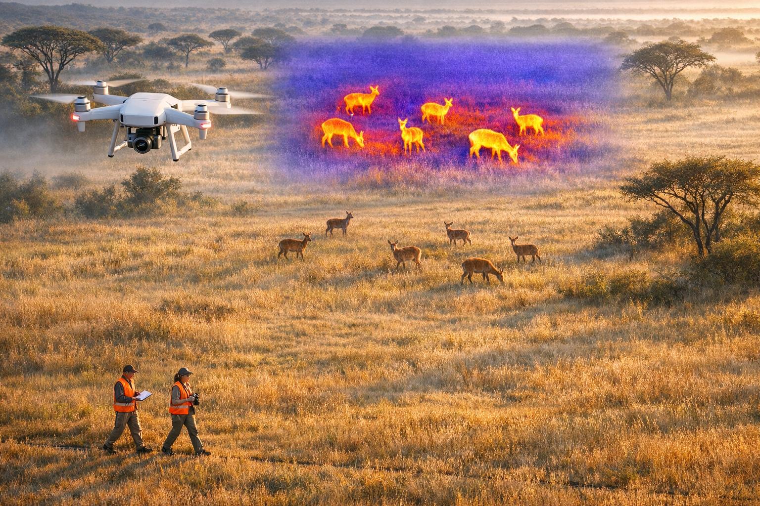
Thermal drones are transforming wildlife monitoring. They use heat detection to locate animals even in dense vegetation, offering faster, more accurate data compared to older methods like helicopter surveys, camera traps, and ground-based techniques. However, they come with challenges like high initial costs, complex data processing, and environmental limitations.
Key takeaways:
- Thermal drones excel in efficiency, covering large areas quickly and detecting animals with up to 92% accuracy in optimal conditions.
- Traditional methods like camera traps are cost-effective and provide detailed demographic data but are slower and less accurate.
- Each method has trade-offs in cost, accuracy, and wildlife impact.
Quick Comparison
| Criteria | Thermal Drones | Traditional Methods |
|---|---|---|
| Efficiency | Covers large areas quickly | Slower, labor-intensive |
| Cost | High upfront, lower operational costs | Generally lower initial costs |
| Accuracy | Up to 92% in optimal conditions | Limited by field of view and detection |
| Wildlife Impact | Minimal at high altitudes | Potential stress on animals |
| Data Insights | Population density estimates | Detailed demographic data |
Bottom line: Choose thermal drones for speed and large-scale surveys. Opt for traditional methods when detailed demographic insights are needed.

Thermal Drones vs Traditional Wildlife Survey Methods Comparison
Thermal Drones for Wildlife Monitoring
How Thermal Drones Work
Thermal drones rely on detecting thermal infrared radiation - essentially the body heat emitted by warm-blooded animals. This heat creates a clear contrast against cooler surroundings, making it possible to spot animals even in dense vegetation or when they're motionless. The best results occur when there's a strong temperature difference between the animal and its environment, which is why flights during evening, night, or early morning are most effective.
In March 2017, researchers at Auburn University's deer research facility in Alabama tested a thermal drone on a population of 151–163 captive deer. The drone's density estimate was 92% accurate compared to the known population (82.7 deer per square mile) during evening flights, outperforming traditional human-piloted aerial surveys.
Drones can operate in two modes: manual or autonomous. Manual flights allow operators to hover and adjust the angle for real-time species identification, while programmed routes systematically cover larger areas. A 2022 study in Chitwan National Park, Nepal, compared these approaches across four grassland sites. While both methods delivered similar mammal counts, manual flights were 57% faster (35 minutes compared to 66 minutes) and provided better species identification.
Thermal videography is particularly effective because it captures movement, helping distinguish live animals from static heat sources like rocks or tree stumps. For example, a drone flying at 394 feet above ground can cover a horizontal field of view of 328 feet, with a ground resolution of about 6.1 inches per pixel.
These capabilities make thermal drones a powerful tool for wildlife monitoring, offering efficiency and precision.
Advantages of Thermal Drones
Thermal imaging comes with several benefits that make it an excellent choice for wildlife monitoring.
The efficiency boost is one of the most striking advantages. Between May and July 2019, researchers from the University of Newcastle conducted 10 comparative surveys in Port Stephens and Gilead, NSW, Australia. They found that thermal drones had a detection probability of 83.3%, compared to 38.9% for traditional spotlighting and just 4.2% for the Spot Assessment Technique (SAT). Additionally, drones detected one koala every 2.18 hours, while ground teams took 6.75 hours to find a single animal - over three times less efficient.
"Thermal infrared cameras... have the advantage over conventional RGB cameras of being able to distinguish animals based on their body heat and being able to detect animals at night."
- Dr. Claire Burke, Liverpool John Moores University
Drones can also autonomously survey large, hard-to-reach areas, reducing the labor required for ground teams. For example, from 2016 to 2018, researchers at Pilot Mountain State Park in North Carolina used a Linn Aerospace Hummingbird quadcopter equipped with a FLIR Vue Pro 640 sensor. Flying at 394 feet, the drone delivered density estimates comparable to long-term camera trap data but with greater speed and precision.
This technology is especially effective for detecting nocturnal or camouflaged animals that standard color cameras might miss. During winter, for instance, koalas appeared 17.1% brighter than the surrounding vegetation in thermal imagery.
Drawbacks of Thermal Drones
While thermal drones offer many advantages, they also come with notable challenges.
The initial cost is a major hurdle. Thermal sensors are significantly pricier than standard RGB cameras and often deliver lower resolution. Operating these drones also requires specialized skills - not just in flying but also in interpreting thermal imagery, which can be tricky when multiple species share similar heat signatures.
Data processing adds another layer of complexity. In the Chitwan National Park study, standard orthomosaic processing struggled to handle moving animals, as strict image overlap requirements often excluded them.
Environmental conditions can also affect performance. Dense forest canopies or lush vegetation can obscure animals' heat signatures. Additionally, "thermal washout" occurs when the ground absorbs too much solar heat, reducing the temperature difference between animals and their surroundings.
Lastly, the sheer volume of data generated increases post-processing demands. Programmed flights, for example, can produce 138% more images and require 57% more flight time compared to manual flights. This creates a heavier workload for analysis, and both real-time identification during manual flights and post-flight data review remain vulnerable to human error.
These obstacles highlight the trade-offs between thermal drones and simpler, more traditional methods, setting the stage for a deeper comparison later in this article.
sbb-itb-ac6e058
Traditional Wildlife Survey Methods
Common Traditional Survey Techniques
Traditional wildlife survey methods include a variety of well-established techniques. One widely used approach is camera trapping, where infrared-triggered cameras automatically capture images of animals at specific locations. These cameras act as round-the-clock observers with minimal need for human intervention, typically deployed at a density of one camera per 100 acres for monitoring large animals like deer.
Another method, mark-resighting, estimates population sizes by analyzing the ratio of identifiable individuals - either naturally marked or tagged - to the total number of sightings. N-mixture modeling, on the other hand, uses repeated count data from multiple locations to statistically estimate abundance without needing to identify individual animals. For broader surveys, piloted aerial surveys involve human observers counting animals from helicopters or planes, while ground transect surveys rely on researchers walking or driving along fixed routes to record signs of wildlife.
To illustrate the application of these methods, researchers from Wake Forest University conducted a study at Pilot Mountain State Park in North Carolina between June 2016 and September 2018. Led by Robert W. Baldwin, the team deployed 22 Cuddeback E3 cameras over a 3.95-square-mile grid. This effort, which generated 16,775 photos of white-tailed deer, aimed to compare traditional techniques like mark-resighting and N-mixture modeling with newer drone-based technologies.
While these time-tested methods have paved the way for wildlife research, they come with their own strengths and limitations.
Advantages of Traditional Methods
Traditional survey methods have stood the test of time, offering reliability and practicality, especially in areas where advanced technology may not be feasible. As Robert W. Baldwin of Wake Forest University explains:
"Camera traps, once deployed, serve as long-term fixed observers operating continuously in a wide range of environmental and climatic conditions with minimal human attention".
These methods do not require costly equipment like thermal sensors or the specialized skills needed to operate drones. For example, mark-resighting can provide critical demographic insights, such as age and sex ratios, which are essential for understanding population dynamics. Ground-based techniques are particularly useful in remote areas with limited infrastructure, and they avoid the regulatory challenges often associated with drone use. The tools involved - cameras, binoculars, and notebooks - are simple yet effective, making them accessible for a wide range of researchers.
However, despite their dependability, these methods are not without their challenges.
Drawbacks of Traditional Methods
Traditional wildlife survey techniques face several notable limitations. One major issue is imperfect detection. Camera traps, for instance, only capture activity within a limited field of view, making it difficult to differentiate between an animal's absence and a missed sighting. Similarly, ground-based counting methods often underestimate populations of certain species, such as colonial mammals.
These methods can also be resource-intensive. For example, a 2019 study of koalas in New South Wales highlighted the inefficiency of traditional techniques: systematic spotlighting required 6.75 hours per detection, while the Spot Assessment Technique took over 43 person-hours per detection. The high costs and risks of aerial surveys further compound these challenges. As Annalysa M. Camacho from Texas A&M University-Kingsville points out:
"Helicopters used for aerial wildlife surveys are expensive, dangerous and time consuming".
Statistical methods like N-mixture modeling add another layer of complexity. They depend on assumptions - such as closed populations and consistent detection probabilities - that are often unrealistic in field conditions. For instance, a 2017 Auburn University study of captive deer in Alabama found that human-occupied aerial surveys had lower detection rates compared to newer technologies. In some cases, aerial surveys detected only 10% of chimpanzee nests counted via ground surveys in forested areas.
Another concern is the potential disturbance to wildlife. Ground surveys and low-flying aircraft can stress animals and alter their behavior. Additionally, techniques like canopy camera trapping require professional climbers to transport heavy equipment through challenging terrain, increasing the physical impact on sensitive habitats.
These challenges highlight the trade-offs involved in relying on traditional methods, particularly as newer technologies continue to emerge.
Deer Surveys with Thermal Drones and Trail Cameras - The Night Vision Show
Thermal Drones vs. Traditional Wildlife Surveys
When comparing thermal drones to traditional wildlife survey methods, key factors like efficiency, cost, accuracy, and impact on wildlife reveal the strengths and limitations of each approach.
Efficiency and Area Coverage
In May 2022, programmed drone flights covered 9,360 meters in 66 minutes, surpassing manual flights, which covered 6,370 meters in 35 minutes - a 47% increase in distance. Drones can autonomously follow preplanned routes, allowing them to efficiently survey areas that are difficult to access by foot. However, environmental factors such as dense foliage, thick brush, and high sunlight reflection can hinder thermal detection. As Michael McMahon from the University of Minnesota observed:
"UAS surveys were more efficient and required less field effort than conventional pellet count surveys".
Helicopter surveys, a traditional method, often show inconsistent results, detecting only 20% to 70% of marked white-tailed deer in some cases. Between 2016 and 2018, researchers at Pilot Mountain State Park in North Carolina compared camera traps with aerial thermal videography using a Linn Aerospace Hummingbird quadcopter. The drones provided comparable density estimates in significantly less time than the 22 camera traps deployed over nearly four square miles. This efficiency highlights the potential for thermal drones to streamline wildlife monitoring processes.
Cost Comparison
Traditional helicopter and airplane surveys are expensive and come with safety risks.
Thermal drones, while requiring a higher initial investment, have lower operational costs compared to manned flights. However, they generate a much larger volume of images, which increases the time needed for post-processing. For example, at Chitwan National Park, programmed drone flights averaged 205 images per session, compared to 86 images for manual flights, even though both methods produced similar mammal counts.
Camera traps, on the other hand, are one of the most cost-effective long-term options. As Robert W. Baldwin and his team explain:
"Camera traps are less invasive, less labor-intensive, and more cost-effective than many other ecological monitoring techniques".
In the Pilot Mountain study, cameras were deployed at a density of one per 100 acres, a common practice in wildlife management. While camera traps require periodic maintenance, such as battery and SD card replacements, their ability to operate continuously with minimal human intervention makes them an economical choice for extended monitoring.
Accuracy and Data Quality
Precision is just as important as speed when it comes to wildlife surveys. Evening flights by a fixed-wing thermal drone at Auburn University achieved a density estimate covering 92% of a known population. Similarly, drone surveys for large ungulates recorded an average density estimate of 69.8 deer per square mile, or around 78% of the known population. Timing plays a crucial role in accuracy - optimal surveys are conducted during twilight or in winter months when leaf-off conditions improve thermal contrast.
Traditional methods, such as camera traps, face limitations in their field of view, which can lead to missed detections. For instance, in the Pilot Mountain study, three methods - mark-resighting, N-mixture modeling, and aerial thermal videography - produced similar density estimates, reinforcing drones as an effective tool for accurate and rapid data collection.
Impact on Wildlife and Habitat
The level of disturbance caused by each method varies significantly. Helicopter surveys are noisy and visually disruptive, posing risks to both wildlife and survey crews. Ground surveys, while less loud, require researchers to enter sensitive habitats, potentially altering animal behavior. Similarly, setting up canopy-level camera traps often involves moving heavy equipment through rugged terrain.
Thermal drones, however, offer a less intrusive alternative. In November 2022, researchers led by Hanne Lyngholm Larsen tested a DJI Matrice 300 RTK drone at a bait station in Brovst, Denmark. They found that European badgers were undisturbed at altitudes above 197 feet, and stone martens remained largely unaffected by noise levels of 55–61.5 dB. Larsen concluded:
"Frame thermal images were effective in species recognition and for use in population studies of deer, and are thought to be more time-efficient and less invasive than traditional methods".
At Pilot Mountain, drones maintained detection accuracy while reducing habitat disturbance. Fixed-wing drones, in particular, generate less noise compared to similarly sized multirotor drones, although their visual profile may appear more intimidating to some species. As Robert W. Baldwin points out:
"Advancing technologies are adding and refining methods that observe wildlife with little or no disturbance".
Conclusion: Selecting the Right Wildlife Monitoring Method
Key Takeaways
Choosing the best wildlife monitoring method depends on your specific project goals and the environment you're working in. Thermal drones are highly effective for quickly estimating population densities over large areas. They perform particularly well in open grasslands or deciduous forests during winter when leaf-off conditions improve visibility. The ideal conditions for using thermal drones are ambient temperatures below 68°F on clear days or below 81°F on cloudy days. However, their effectiveness can be limited by dense canopy cover or thick vegetation, which can obstruct thermal signatures.
On the other hand, camera traps excel at capturing detailed demographic data, such as identifying individual animals, determining sex ratios, and tracking age groups. These are areas where low-resolution thermal sensors often fall short. For example, the Pilot Mountain study (2016–2018) highlighted how drones provided quick density estimates, while camera traps delivered richer demographic insights. For long-term studies that require individual animal identification, the more detailed data from camera traps may justify their additional setup time and effort.
Timing is also critical when using thermal drones. Flights scheduled within an hour of sunrise or sunset maximize thermal contrast. A study conducted at Auburn University in March 2017 found that evening flights achieved a 92% accuracy rate for detecting a known deer population, whereas morning flights were significantly less effective. Additionally, cloudy conditions can enhance thermal contrast, extending the survey window by up to 12.6°F.
The Future of Wildlife Surveys
Emerging trends are shaping the future of wildlife monitoring. One major factor is climate change, which is narrowing the seasonal windows for thermal drone surveys as rising nighttime temperatures reduce thermal contrast. This challenge is pushing the adoption of AI-powered solutions to process thermal imagery more efficiently. Machine learning algorithms are increasingly being used to automate species identification from thermal videos, reducing the time and effort required for post-processing. Notably, programmed drone flights can generate 138% more images compared to manual flights, further emphasizing the need for efficient data management.
Platforms like Anvil Labs are stepping up to meet these demands by offering tools that streamline the management and analysis of thermal imagery alongside other spatial data. As Annalysa M. Camacho and her team pointed out:
"Drones present the opportunity to survey areas quickly and repeatedly, a distinct advantage over other methods of aerial surveys".
To fully harness these advancements, having a robust data management system in place will be key to unlocking the potential of these technologies in wildlife monitoring.
FAQs
What wildlife can thermal drones miss?
Thermal drones can sometimes fail to detect wildlife with low heat signatures or species that blend seamlessly into their surroundings. This challenge applies to cold-blooded animals, creatures with dense fur, and those hidden within thick vegetation. Additionally, smaller animals or those shielded by terrain features might go unnoticed, as thermal cameras often struggle to pick up slight temperature variations or spot animals concealed by foliage or intricate habitats.
Do I need FAA approval to fly thermal drones?
Yes, if you're planning to operate thermal drones for commercial purposes, you’ll need FAA approval under the Part 107 regulations. Be sure to follow all the required guidelines to stay compliant with commercial drone use rules.
How do I manage and analyze all the thermal data?
Platforms like Anvil Labs are designed to help you manage and analyze thermal data collected from drone surveys. These tools handle thermal imagery, allowing for seamless data processing, annotation, precise measurements, and secure sharing.
Anvil Labs offers features such as heat map generation, spatial analysis, and temporal comparison, making it easier to organize and interpret data. These capabilities are especially useful for tasks like wildlife detection and analyzing temperature variations, streamlining research efforts and improving decision-making processes.
