
Cloud platforms are reshaping how teams handle LiDAR data, reducing errors, costs, and time delays. By automating processes like defect detection and data classification, these tools cut processing time by up to 75% and improve defect identification by 30%. They also remove the need for expensive hardware and enable real-time collaboration via web-based access. However, costs like storage fees and data transfer charges should be considered.
Key Benefits of Cloud Platforms:
- Faster Processing: Automation significantly speeds up tasks like noise filtering and 3D model creation.
- Improved Collaboration: Teams can share and interact with data online without specialized software.
- Scalability: Handle large datasets without the need for costly hardware upgrades.
- Automation: AI-powered tools reduce manual effort and improve accuracy.
Challenges:
- Cost: Pay-as-you-go models can add up, especially for large datasets.
- Internet Dependency: Reliable connectivity is essential for cloud-based workflows.
Cloud solutions like Anvil Labs offer pricing starting at $49 per project, making them accessible for various project sizes. While traditional workflows offer more control, cloud platforms provide a streamlined, efficient alternative for managing complex LiDAR projects.
1. Older LiDAR Workflows
Processing Efficiency
Traditional LiDAR workflows were riddled with inefficiencies that slowed down progress. According to a study by the National Institute of Standards and Technology (NIST), engineers spent 40% of their time just locating and validating information instead of focusing on actual analysis tasks.
The hardware demands added another layer of complication. These workflows required high-performance desktops and proprietary software, limiting access to users with specific setups. Imagine every team member needing software like Photoshop - not only costly but also restrictive.
"Historically data storage has been a stubborn bottleneck challenge for enterprise customers interested in data management." - LIDAR Magazine
These inefficiencies didn’t just affect individual productivity - they also made collaboration across teams much harder.
Collaboration Capabilities
Sharing LiDAR data among teams was anything but simple. Many companies relied on decentralized storage methods, like physical hard drives or local networks, which made it difficult to manage data consistently. When multiple teams worked on the same project, metadata and source files often got lost in the shuffle.
"Lidar data management for enterprise customers can become complicated when different data sources are used to generate new products or multiple teams share data creation." - LIDAR Magazine
Accessing and using the data was another hurdle. For every person contributing scan data, there were typically ten others who needed to use it. Yet, without specialized skills in tools like Python or MATLAB, many team members were left out.
Scalability and Storage
Handling large-scale LiDAR projects posed serious challenges due to storage limitations. Traditional systems relied on "shared-memory" or "shared-disk" architectures, which could only scale vertically. This meant that as data volumes grew, organizations had to upgrade to more expensive hardware - a costly and unsustainable solution.
Take the US 3DEP program, which generated nearly 14 trillion data points, or the Netherlands' AHN2 project with over 640 billion point records. These massive datasets pushed traditional file systems to their limits. Organizations were forced to invest heavily in fixed server infrastructures that weren’t built to handle such enormous data loads.
The lack of scalable storage options made it difficult for teams to keep up with the growing demands of large projects.
Automation Features
Automation was virtually nonexistent in older workflows, which dragged out project timelines. Teams had to manually handle tasks like noise filtering and point classification, which not only ate up time but also increased the risk of errors. To maintain consistency, organizations had to rely on strict process documentation, adding even more administrative overhead.
Without automation, repetitive tasks that software could have easily managed ended up consuming valuable human resources. This inefficiency made it harder for teams to focus on more critical, high-value work.
Modern cloud platforms have started to tackle these pain points, offering automation and freeing teams from hardware limitations.
sbb-itb-ac6e058
2. Cloud-Based LiDAR Platforms (e.g., Anvil Labs)
Processing Efficiency
Cloud platforms have completely changed how LiDAR data is processed, taking over tasks that were once manual and time-consuming. By automating processes like noise filtering and point classification, these systems transform drone data into accurate 3D models and orthomosaics with minimal effort. This shift has cut processing time by an impressive 75% and saved teams hundreds of thousands of dollars, often delivering a return on investment (ROI) in just two months. Angel Rojas from Red Angel Drones shared his experience:
"My overall experience with the software has been satisfying because of the efficient workflow... The ROI is clearly marked within the first few uses."
Additionally, AI-powered analysis has boosted defect detection by 30%, reducing the need for rework. These advancements not only save time and money but also improve collaboration, as outlined below.
Collaboration Capabilities
Gone are the days of needing specialized software or dealing with massive file transfers to share LiDAR data. Platforms like Anvil Labs make it easy for teams to view, rotate, and interact with LiDAR files (such as .laz), meshes, and orthomosaics directly in a web browser. Clients can even measure and analyze hosted data online.
This centralized approach solves the problem of scattered files and missing metadata. Teams can securely share entire project galleries or specific files via role-based access links. Connor Barnes from Leading Edge Environmental and Emergency Services highlighted the value of this functionality:
"I had a meeting yesterday with my clients and they really liked the panoramas. I appreciate all the cool tech you've got here. This saves me from DroneDeploy!"
Anvil Labs offers simple pricing: $99 per month for platform access or $49 per project for hosting and management.
Scalability and Storage
Traditional workflows often hit hardware limits, but cloud platforms remove these barriers. Instead of upgrading expensive desktops to handle large point clouds, teams can use remote processing engines to access data from any device. Storage options range from 500 GB for smaller projects to over 2 TB for enterprise needs. Advanced techniques like tiling and parallel processing ensure smooth handling of even massive datasets, with some platforms managing over 1 million acres of LiDAR data each month.
Automation Features
Modern cloud platforms combine AI and sensor technology to automate tasks like compliance checks, reporting, and defect detection. These features not only reduce human error but also free teams from repetitive work. Automated processing costs just $3 per gigapixel, making it affordable for projects of all sizes.
This level of automation is transforming how teams handle LiDAR data. Adrian, a drone service provider, summed it up perfectly:
"This is a differentiator. Those that aren't able to provide visualization but are just doing raw footage - this gives you, in my opinion, that competitive edge."
The Most Powerful and Easy To Use LiDAR Software - LiDARMill from Phoenix LiDAR Systems
Pros and Cons
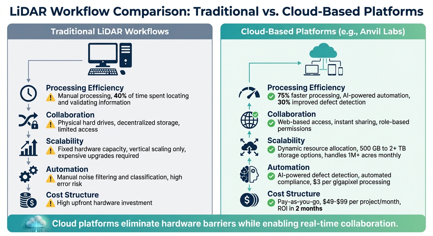
Traditional vs Cloud-Based LiDAR Workflows Comparison
When comparing traditional and cloud-based LiDAR workflows, each approach has its own strengths and limitations. Traditional workflows provide complete control over data but come with significant upfront hardware costs and the risk of overloading local computing resources. These challenges have led many to explore cloud-based alternatives.
Cloud platforms, on the other hand, eliminate the need for expensive workstations and speed up processing through automated workflows. They also offer scalable resources that adapt to project demands and enable secure, web-based collaboration in real-time. However, this convenience isn’t without its drawbacks - ongoing operational costs, such as storage fees for large datasets and charges for moving data in and out of the cloud, can add up over time.
One of the standout benefits of cloud workflows is their automation capabilities. Tasks like noise filtering, defect detection, and compliance reporting are powered by AI, significantly reducing manual effort. As Esri highlights:
"Processing, including serving data or any analytics, should happen in the same infrastructure where the images are stored; otherwise, the large data transfer will be slow and could incur a high egress cost".
Here’s a quick comparison of key features in both workflows:
| Feature | Traditional LiDAR Workflows | Cloud-Based Platforms (e.g., Anvil Labs) |
|---|---|---|
| Processing Efficiency | Slow and labor-intensive manual processing | Faster, leveraging automated AI-powered workflows |
| Collaboration | Requires physical data transfer via hard drives | Enables instant sharing through secure web platforms |
| Scalability | Limited by fixed hardware capacity | Dynamically adjusts resources to meet project needs |
| Automation | Relies on manual quality checks and compliance | Automates defect detection, reporting, and compliance |
| Cost Structure | High initial hardware investment | Pay-as-you-go model with potential storage fees |
Choosing between these workflows depends on your project's specific requirements. For organizations managing multiple large-scale projects and working with distributed teams, cloud platforms can become cost-effective in as little as two months. However, if your work involves highly sensitive data or you face unreliable internet connectivity, traditional workflows may still be the better option.
Conclusion
Cloud-based LiDAR workflows are transforming the way projects are managed by eliminating manual processing, disconnected tools, and hardware limitations. By automating tasks, centralizing data, and scaling resources, these workflows create a smoother and more efficient process. As Tiana Warner from Safe Software puts it:
"Automations can then be used to run the workspace as part of an event-based workflow, which reduces manual effort and frees up time and resources".
These advancements deliver tangible results: inspections are completed 75% faster, with 30% more defects detected, and projects often see a return on investment within just two months.
That said, it’s crucial to align your project scope and precision needs to avoid unnecessary expenses. For example, platforms like Anvil Labs simplify budgeting with per-project pricing starting at $49, offering a clear and predictable cost structure - an advantage when passing expenses on to clients.
With added benefits like enhanced visualization tools and automated compliance tracking, cloud platforms are proving to be a game-changer for modern LiDAR workflows. They not only streamline operations but also support more agile project management. Starting with a pilot project can help you explore the benefits of automation, centralized storage, and real-time collaboration. The real question isn’t if you should make the switch but when.
FAQs
How do cloud platforms make LiDAR workflows faster and more efficient?
Cloud platforms make LiDAR workflows easier by offering scalable processing power and centralized data management. This means massive datasets can be handled faster than with traditional on-premises systems, cutting down the time needed for tasks like data cleaning, analysis, and visualization.
On top of that, cloud-based tools allow teams to collaborate effortlessly. With secure access from anywhere and on any device, team members can work together in real-time, share annotations, and make quicker decisions. This streamlined approach boosts overall project efficiency.
What are the cost considerations when using cloud-based LiDAR platforms?
Cloud-based LiDAR platforms come with a mix of costs to keep in mind. While they save you from the expense of on-site infrastructure, the initial setup fees typically fall between $45,000 and $60,000. Beyond that, there are ongoing costs, including storage fees, data transfer charges, licenses for advanced functionalities, and even training expenses for your team.
Though these recurring costs can sometimes surpass those of traditional storage options, the trade-off often comes in the form of better efficiency, scalability, and improved collaboration. To make the best decision, take a close look at your project’s specific requirements and usage patterns to weigh the overall value.
How does cloud-based collaboration improve LiDAR workflows?
Cloud-based collaboration simplifies LiDAR workflows by giving teams the ability to share, view, and edit point cloud data instantly on a shared platform. This approach removes the hassle of manual file transfers and ensures everyone is always working with the latest information.
By offering tools like centralized version control and real-time project tracking, cloud platforms help teams make quicker decisions, minimize mistakes, and boost overall productivity. Whether team members are in the office or on-site, they can work together effortlessly, saving both time and money.
