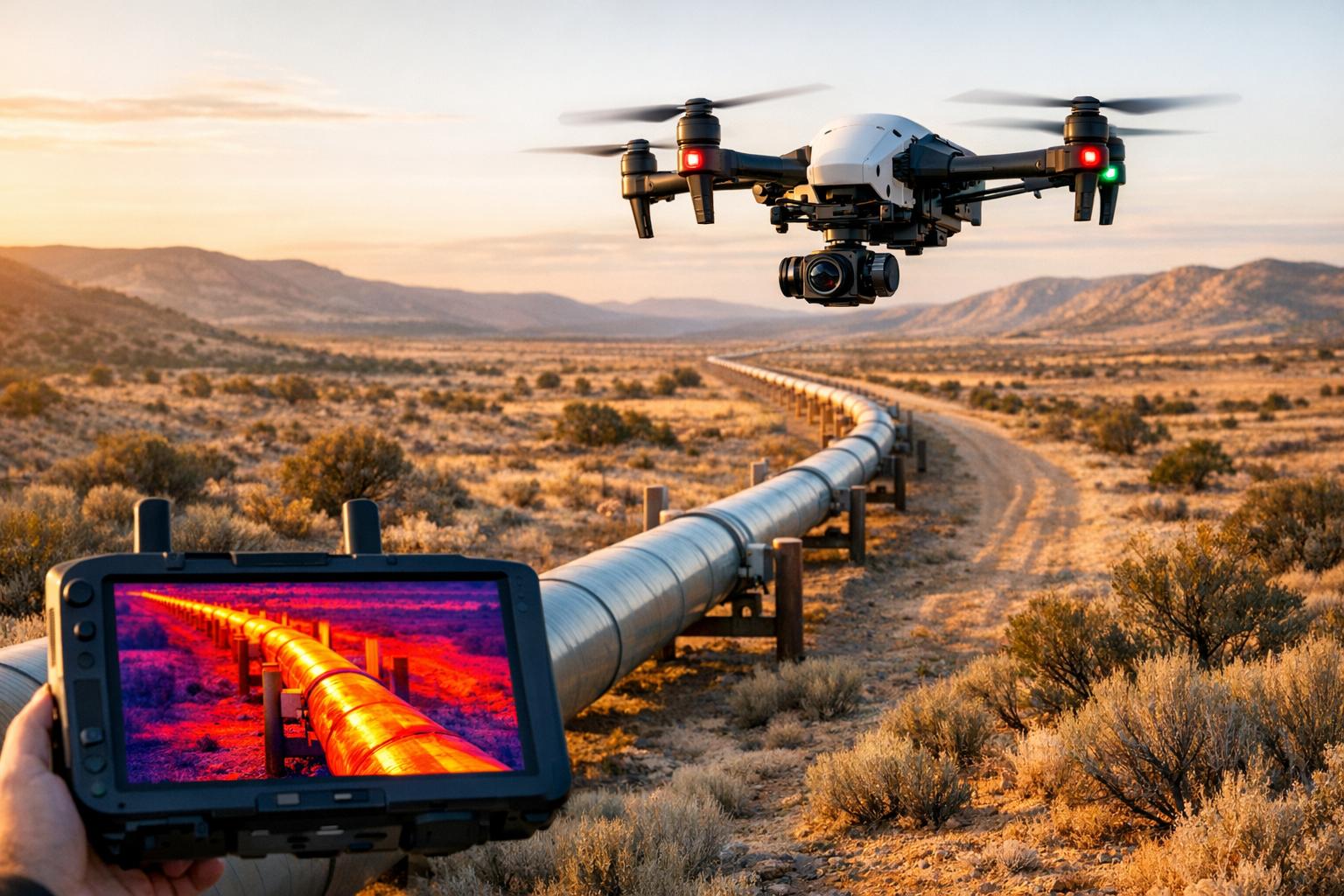
Drones with thermal imaging are transforming how oil and gas pipelines are monitored. They detect leaks by identifying temperature changes in the surrounding environment, offering faster, safer, and more cost-effective inspections compared to older methods like manual checks or helicopter flyovers. Equipped with advanced sensors, drones can spot issues like methane leaks or stressed vegetation caused by underground spills, improving accuracy and reducing risks.
Key highlights:
- Faster inspections: Drones cover large areas quickly, reducing labor costs.
- Improved safety: No need to send workers into hazardous zones.
- Advanced detection: Thermal cameras and gas sensors identify leaks invisible to the naked eye.
- Cost savings: Avoiding operational shutdowns and reducing downtime.
Modern tools like AI-powered analysis, multispectral cameras, and advanced platforms for data processing help turn raw thermal data into actionable insights. While challenges like weather conditions and battery life remain, the benefits of drone-based thermal imaging are reshaping pipeline monitoring.
How Thermal Imaging Detects Pipeline Leaks
Detecting Temperature Variations
Thermal cameras don’t directly "see" gas or liquid escaping from pipelines. Instead, they detect infrared radiation, which is emitted by any object warmer than absolute zero, and map out temperature differences. When a leak occurs, it causes temperature changes in the surrounding area, and that’s what these cameras pick up.
"With respect to pipe leaks, a thermal imaging camera does not actually 'see' moisture; however, it is used to detect small temperature differences that often arise from leaking pipes." - Tim Hoffer, CEO/COO, SoftDig
The detection method varies depending on whether the pipeline is above ground or buried. For above-ground pipelines, thermal cameras identify hot spots caused by insulation breakdowns or structural flaws. For buried pipelines, the process is less direct. Leaking fluids alter the temperature of the surrounding soil, creating thermal anomalies that stand out from the natural ground temperature. For instance, a hot oil leak will warm the soil above it, while escaping gas often cools the area due to pressure drops and evaporation.
Drones equipped with high-resolution sensors (640 x 512 pixels) provide the detailed images needed for precise inspections. A critical factor in this process is the Noise Equivalent Temperature Difference (NETD) - a lower NETD value means the sensor can detect even the smallest temperature changes, which is vital for spotting minor leaks. Inspections are most effective at night or during winter months when solar interference is minimal.
Environmental Indicators
Thermal imaging doesn’t just rely on direct temperature changes; it also identifies secondary environmental clues that point to leaks. One of the most telling indicators is vegetation health. For example, when saltwater or produced water leaks into the soil, it raises soil salinity, which can kill or stress nearby plants. Drones equipped with multispectral cameras can calculate a Vegetation Index to detect these stressed or dying plants, often revealing underground leaks before they become visible on the surface.
Soil properties also significantly influence detection accuracy. Factors like moisture content and soil density determine how heat from a buried leak travels to the surface. For deeper pipelines, the leak needs to be larger or create a more pronounced temperature difference to be noticeable. Additionally, environmental conditions like wind and humidity play a role. Wind speeds above 10 mph (roughly 4.5 m/s) disperse gas plumes, making leaks harder to detect. Similarly, high humidity reduces thermal contrast, making anomalies less distinct. To ensure accurate results, operators carefully schedule flights during calm weather with low to moderate wind and optimal conditions for capturing clear thermal signatures.
sbb-itb-ac6e058
Pipeline Inspection Workflow | Using Drone and Thermal Imaging Camera WIRIS Pro
Key Technologies in Drone-Based Thermal Imaging
Advanced sensor technologies are at the heart of improving the precision of thermal imaging for pipeline inspections.
Thermal Sensors and Imaging Systems
The backbone of any pipeline inspection drone is its thermal sensor, and the type of sensor heavily influences its performance. High-resolution, industrial-grade sensors (e.g., 640 x 512 pixels) generate detailed thermal images that are crucial for accurately detecting leaks. However, resolution alone isn’t enough - sensor type plays a pivotal role.
Cooled sensors, such as those using Indium Antimonide (InSb) detectors, offer significantly higher sensitivity compared to uncooled options. For instance, the Workswell GIS-320, equipped with a cooled InSb detector, delivers 320 x 240 resolution thermal images capable of identifying gas leaks that are otherwise undetectable by the naked eye.
"detects the smallest of leaks and even meets multiple regulatory sensitivity standards" - Steve Beynon, EMEA Optical Gas Imaging Specialist at Teledyne FLIR
For Optical Gas Imaging (OGI), drones often rely on Mid-Wave Infrared (MWIR) or Long-Wave Infrared (LWIR) sensors. These sensors not only detect heat but also visualize hydrocarbon plumes by capturing unique infrared absorption patterns of gases like methane. Many systems now incorporate High Sensitivity Mode (HSM), a patented feature that enhances thermal contrast, making even the smallest gas plumes visible against complex backgrounds.
Flight endurance is another critical factor. Professional-grade thermal drones, such as the DJI Mavic 3 Thermal, can stay airborne for up to 45 minutes, while the DJI Matrice 30T offers around 41 minutes of flight time. In contrast, standard drones typically manage only 15 to 20 minutes.
Complementary Sensors and Tools
Beyond thermal sensors, modern drones integrate additional tools to refine and expand their leak detection capabilities. These complementary technologies help provide a more comprehensive assessment of pipeline conditions.
Tunable Diode Laser Absorption Spectroscopy (TDLAS) enhances thermal imaging by quantifying gas concentrations. This technology emits laser pulses at specific wavelengths, and if methane is present, the gas absorbs part of the light. By analyzing the altered reflection, TDLAS can detect methane up to 300 meters away and measure concentrations in ppm·m, allowing operators to estimate leak rates. These systems typically cost between $10,000 and $60,000.
Direct-sampling sniffers offer another method for detecting gas concentrations by drawing in air samples. These sensors work at closer ranges, hovering about 10 to 16 feet from the source, and measure real-time gas levels in parts per million. Although they require proximity, they excel at creating 3D concentration maps to pinpoint exact leak locations. Prices for these systems range from $2,000 to $20,000.
Gas Mapping LiDAR (GML) pushes the boundaries by combining 3D terrain mapping with methane concentration data. This technology overlays leak information onto high-resolution maps, helping operators identify physical risks like erosion, vegetation overgrowth, or encroachments along the pipeline. Current research is focused on reducing the size, weight, and power requirements of GML systems to make them compatible with smaller drones.
Finally, multispectral cameras provide an additional layer of detection. While thermal sensors excel at identifying hydrocarbon leaks, they may miss other types of leaks, such as saltwater or produced water spills. These leaks can affect vegetation health without generating a thermal signature. Multispectral cameras calculate Vegetation Indices to spot stressed or dying plants, potentially revealing underground leaks before they become visible on the surface. This makes them especially useful for detecting non-hydrocarbon fluid leaks.
Recent Research and Findings
Recent advancements in AI and thermal imaging are pushing the boundaries of leak detection, making it more accurate and efficient.
AI-Powered Analysis and Reducing False Positives
In April 2025, Eddie and Evan Zhang from The Harker School introduced a groundbreaking pipeline leak detection system. Their approach used an Improved Deep Forest Classifier (IDFC), combining thermal imaging with gas sensor data. By implementing a two-step feature selection process, they achieved an impressive 98.9% detection accuracy. Even more remarkable, the model was compact - just 115 MB - allowing it to run on robotic systems for real-time hazard detection.
Modern AI tools now integrate various neural networks with persistency filters, requiring six consecutive thermal frames to validate results. This approach significantly reduces false positives. Additionally, explainable AI techniques like Grad-CAM, paired with lightweight edge processing, make real-time thermal data analysis not only possible but also verifiable.
These developments are reshaping detection capabilities, offering both precision and adaptability for more complex operational demands.
Beyond Visual Line of Sight (BVLOS) Operations
Marathon Pipe Line recently conducted 198 patrols across 35,706 miles of pipeline, spanning from Alaska to Texas, using FlyScan Systems' remote sensing technology. Machine learning algorithms and hyperspectral imaging identified 2,594 threats, including what’s believed to be the first aerial detection of a diesel seep that standard monitoring systems would have missed.
BVLOS operations are a game-changer for pipeline inspections, especially in remote or hazardous areas where traditional methods - like foot patrols or manned helicopter surveys - fall short. Fixed-wing and VTOL drones provide the necessary speed and endurance to cover extensive routes. Michael Thorpe of Bridger Photonics highlighted the potential of this technology:
"drone-based, and eventually autonomous, deployment of this technology will enable a rapid and cost-effective solution for infrastructure leak monitoring across the supply chain"
To tackle the flight time limitations of conventional multi-rotor drones (typically 15–20 minutes), researchers are exploring hybrid designs. By combining Lighter-Than-Air (LTA) buoyancy with traditional propulsion systems, these hybrids aim to extend flight durations for long-range BVLOS missions. However, challenges persist. Wind speeds exceeding 10 mph (4.5 m/s) can disperse methane plumes, making detection difficult even with high-resolution sensors.
The combination of advanced AI-driven analysis and extended-range drone operations is shaping the future of pipeline monitoring, offering smarter, faster, and more efficient solutions.
Advantages and Challenges
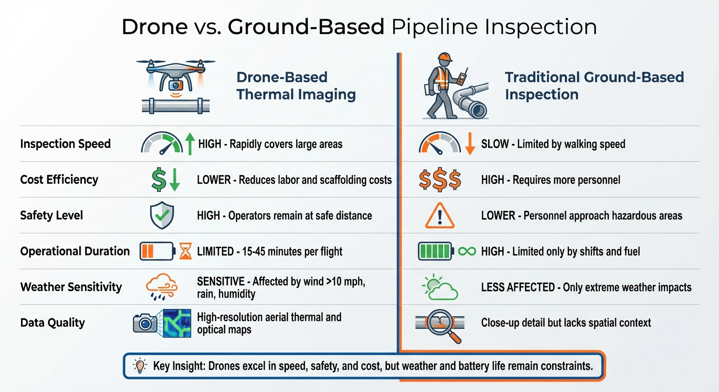
Drone Thermal Imaging vs Ground-Based Pipeline Inspection Comparison
Drone-based thermal imaging has emerged as a game-changer in pipeline leak detection, offering clear benefits over traditional ground inspections. However, like any technology, it comes with its own set of limitations. Weighing these pros and cons helps operators determine the best fit for their specific monitoring needs.
Speed and Cost: Ground inspections, whether on foot or by vehicle, are notoriously slow and labor-intensive, especially in difficult terrain. Drones, on the other hand, can scan vast pipeline stretches in a fraction of the time. They also eliminate the need for costly scaffolding or operational shutdowns. For instance, avoiding drill rig downtime - often priced at around $10,000 per hour - can lead to significant savings.
Safety Improvements: Drones allow operators to stay at a safe distance from dangerous environments, such as areas with flammable methane leaks. The Institute of Flight Guidance has highlighted this advantage:
"Drone-based leak detection has the potential to be more flexible, more efficient, maybe cheaper and also safer compared to the classical methods, as no person is required to approach the leakage spot".
This remote capability is particularly valuable in hard-to-reach areas, such as steep drops or isolated locations. Yet, while the safety benefits are undeniable, technical and environmental factors can limit drones' effectiveness.
Environmental and Technical Constraints: Weather conditions like strong winds (over 10 mph) and high humidity can interfere with thermal imaging, reducing detection accuracy. Battery life is another concern - most multi-rotor drones can only stay airborne for 15 to 20 minutes, though newer models, such as the DJI Mavic 3 Thermal, extend flight times to 45 minutes. In contrast, ground-based inspections are primarily constrained by fuel availability and personnel work hours.
Comparison Table: Drones vs. Ground-Based Methods
Here’s a quick comparison of drone-based thermal imaging and traditional ground inspections:
| Feature | Drone-Based Thermal Imaging | Ground-Based Inspection |
|---|---|---|
| Inspection Speed | High; rapidly covers large areas | Slow; limited by walking speed |
| Cost | Lower; reduces labor and scaffolding | High; requires more personnel |
| Safety | High; operators remain remote | Lower; personnel approach hazards |
| Battery/Endurance | Limited (15–45 minutes per flight) | High; limited by shifts and fuel |
| Weather Limitations | Sensitive to wind, rain, and humidity | Less affected, though extreme weather is a factor |
| Data Resolution | High-resolution aerial thermal and optical maps | Close-up detail but lacks spatial context |
Drone technology offers speed, safety, and cost advantages, but it’s not without its challenges. Operators must balance these factors to ensure effective and reliable pipeline monitoring.
Integrating Thermal Imagery with Digital Platforms
Gathering thermal data using drones is just the beginning. The real game-changer lies in how that data is processed, stored, and shared. Digital platforms take raw thermal imagery and turn it into meaningful insights that improve pipeline monitoring and maintenance. This integration transforms raw visuals into precise, actionable data.
Hosting and Analyzing Pipeline Data
Modern platforms now centralize thermal imagery, LiDAR point clouds, orthomosaics, and 3D photogrammetry models in one place. This multi-sensor approach allows teams to cross-reference various data sources, making it easier to confirm potential leaks and rule out false alarms. For instance, thermal anomalies can be layered over high-resolution 3D LiDAR maps to pinpoint the exact location of a leak and even estimate its severity, improving the accuracy of leak detection workflows.
Anvil Labs is a key example of such a platform, offering comprehensive hosting for diverse data types. Teams can upload thermal images alongside LiDAR scans and orthomosaics for in-depth analysis. The platform’s advanced processing tools automatically highlight temperature anomalies during post-mission reviews. Additionally, AI-powered algorithms like YOLO (You Only Look Once) enable real-time detection of defects such as cracks, corrosion, and leaks directly within the system.
A notable case study comes from BP’s 2015 project in Book Cliffs, Utah, where 3D photogrammetry models were used for training and analysis in areas that were otherwise difficult to access. Curt Smith, BP's Technology Director, emphasized the importance of context in these operations:
"Just flying around is interesting, but you have to know what you are looking at".
Improved Collaboration and Workflow Efficiency
These platforms go beyond data storage - they enhance team collaboration and streamline workflows. With digital tools, teams can review data immediately after collection. Anvil Labs offers integrated features like annotation and measurement tools, enabling team members to mark up thermal imagery, add notes, and measure distances directly on the platform.
GPS integration ensures maintenance crews can locate problem areas with pinpoint accuracy. When paired with fixed network sensors - such as pressure or acoustic monitors - digital platforms help coordinate drone inspections with on-the-ground crews, reducing repair times. Real-time data streaming into centralized control rooms allows operators to monitor pipelines 24/7 and respond instantly, such as activating shut-off valves when leaks are detected.
Engineers can securely access and share critical pipeline data from anywhere, using customizable access controls to involve subject matter experts remotely - even while drones are still in the field. With approximately 3 million miles of pipelines crisscrossing the U.S. energy network, this level of coordination is vital for managing infrastructure on such a massive scale. By uniting drone-based thermal detection with cohesive data management, these platforms significantly improve both accuracy and efficiency.
Conclusion
Drone-based thermal imaging has reshaped the way the oil and gas industry monitors its vast pipeline networks. These drones eliminate the need to send personnel into dangerous areas, significantly lower inspection costs compared to traditional manned aircraft, and cover large distances while identifying subsurface leaks through temperature differences in the surrounding soil.
But technology alone isn’t the full story. The real game-changer lies in how thermal data is processed, stored, and shared. Digital platforms transform raw thermal images into actionable insights, allowing teams to act quickly and precisely when potential issues arise. This integration of data ensures a smooth transition from detection to action.
Take Anvil Labs as an example. Their platform combines various data types - thermal imagery, LiDAR scans, orthomosaics, and 3D models - and turns them into meaningful insights. With AI-driven analysis, the platform flags temperature anomalies automatically. Plus, tools for annotation and measurement enable teams to collaborate in real time, whether they’re on-site or analyzing data remotely. This level of coordination between drone operators and maintenance crews not only speeds up repairs but also helps prevent minor leaks from escalating into major problems.
The benefits of these advancements go beyond just operational efficiency - they also deliver measurable financial and safety gains. BP’s Technology Director Curt Smith highlighted this point:
"There is a lot of money you can save on the operational side. It's not as sexy; but it's big money and it's kind of easy money".
FAQs
How do drones use thermal imaging to detect leaks in oil and gas pipelines?
Drones with thermal imaging cameras are a game-changer for spotting leaks in pipelines. By detecting temperature differences, these cameras can capture infrared heat signatures that reveal unusual hot or cold spots caused by escaping gas or fluids.
What makes this approach stand out is its ability to efficiently and safely cover vast areas. It provides a non-intrusive method to monitor pipelines, helping identify and resolve potential problems before they turn into major issues.
What are the key benefits of using drones for inspecting oil and gas pipelines?
Drones bring a whole new level of efficiency to pipeline inspections compared to traditional methods. For starters, they’re far more budget-friendly than manned aerial surveys, and they can easily navigate to remote or dangerous spots that ground crews might struggle to access safely.
With cutting-edge sensors, such as thermal imaging, drones deliver detailed, high-resolution data, making it easier to pinpoint leaks or identify irregularities with accuracy. Their quick deployment and adaptability make them a game-changer for focused inspections, ensuring pipelines are monitored effectively and reliably.
What are the main challenges drones face during thermal imaging inspections?
Drones encounter a range of hurdles when it comes to thermal imaging inspections. For starters, bad weather, like strong winds or rain, can make flying unsafe and reduce the quality of the imaging. Then there’s the issue of battery limitations - short flight times can be a real challenge, especially for inspecting larger areas.
Cost is another major consideration. Thermal imaging equipment doesn’t come cheap, and the upfront investment can be steep. Even with these obstacles, drones with thermal imaging capabilities are still incredibly effective for spotting leaks and ensuring the safety of oil and gas pipelines.
