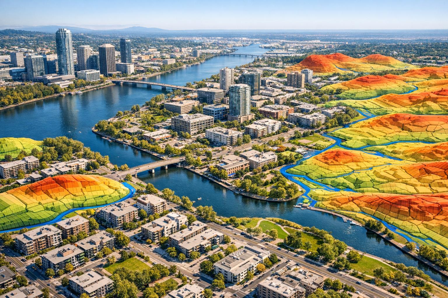
Drone LiDAR is transforming urban flood risk assessment by offering highly accurate, detailed 3D terrain models. Unlike satellite data, which often lacks precision, drone-mounted LiDAR captures small features like curbs, drainage channels, and boundary walls, critical for predicting flood behavior. With vertical accuracy of ±3 cm and resolutions as fine as 0.3 meters, it eliminates errors common in traditional methods, such as overestimating water flow by up to 65% in flat urban areas.
Key Takeaways:
- High Precision: Drone LiDAR provides centimeter-level accuracy, outperforming satellite and airborne methods.
- Improved Flood Models: Captures micro-topographic details for better flood prediction in cities.
- Case Studies: Studies in Accra, Ghana, and La Libertad Dam highlight its effectiveness, showing up to 65% differences in runoff predictions compared to older models.
- Challenges: High costs, data processing time, and point cloud classification remain hurdles.
- Future Developments: Cloud-based platforms and AI tools are simplifying data processing and improving usability.
This technology is helping urban planners make better decisions, reduce costs, and improve public safety by providing reliable data for flood prevention and response.
Using UAS Topobathy LiDAR to Map Vermont Riverine Environments for Enhanced Flood Resilience
Recent Research and Case Studies
Recent research continues to highlight how drone LiDAR is reshaping urban flood risk analysis, offering precision and insights that were previously unattainable.
Case Study: Accra, Ghana
In Accra, Ghana, a study demonstrated the advantages of UAV-LiDAR for capturing detailed micro-topographic features. High-resolution Digital Terrain Models (DTMs) generated by LiDAR revealed that traditional satellite models overestimated runoff volumes by 15% in sloping areas and by a staggering 62.5% in flat urban zones.
"The precision of the location, extent and capacity of landscape sinks were substantially improved when the DTMbs [LiDAR-based DTMs] were utilized for mapping the flood propagation." – Trepekli et al., Researchers
This case underscores how LiDAR can provide unparalleled accuracy, especially in environments where traditional methods fall short.
Case Study: La Libertad Dam, 2024
At La Libertad Dam in 2024, UAV-LiDAR surveys tackled the challenges of rugged terrain with remarkable success. The system produced DTMs with an ultra-high resolution of 5 cm (about 2 inches) and achieved a vertical accuracy of ±3 cm (roughly 1.2 inches). Compared to older methods, this approach improved accuracy by 1.7 m (5.6 ft), enabling the detection of subtle features such as tiny channels, road curbs, and dykes - details that traditional surveying methods often miss.
Common Applications in Urban Flood Mapping
Building on these examples, drone LiDAR has become a cornerstone of urban flood mapping. The process typically involves UAV flights to collect data, the creation of high-resolution Digital Elevation Models, and integration with hydrological modeling tools to identify flood-prone areas. Many cities rely on software like Arc-Malstrøm to analyze LiDAR point clouds, pinpoint "bluespots" (depressions where water accumulates), and trace the exact paths floodwaters might take.
In Sunset Park, Brooklyn, a 2024 study led by Debra F. Laefer from NYU used terrestrial LiDAR to develop a dynamic 3D flood risk viewer. The results were striking - 92% of local participants found the 3D visualizations clearer and more realistic than standard 2D maps, greatly improving their understanding of flood risks and potential water depths.
"3D visual representation is recommended as a mechanism to improve comprehension and navigate risk." – Laefer et al., NYU Tandon School of Engineering
Technical Advantages of Drone LiDAR
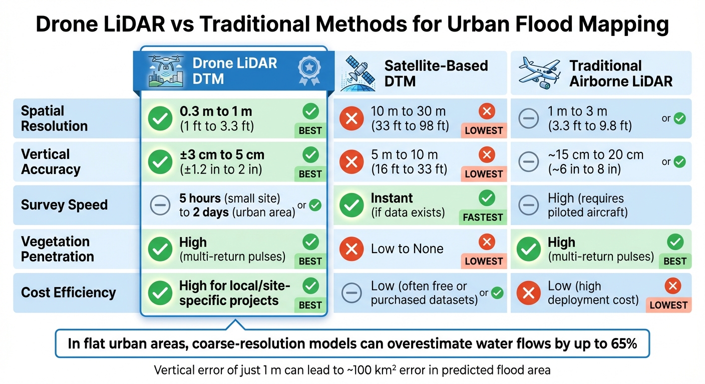
Drone LiDAR vs Traditional Methods: Accuracy and Resolution Comparison for Urban Flood Mapping
High-Resolution Terrain Models
Drone LiDAR excels at capturing the fine details that influence how floodwater moves through urban environments. It can identify features like boundary walls, archways, curbs, bridges, and small drainage channels - elements that satellite sensors simply can't detect but are critical for accurate flood modeling.
One of its standout capabilities is penetrating dense vegetation, allowing it to capture ground data even in areas like overgrown urban parks or riparian zones where photogrammetry falls short. This ensures terrain models remain precise, which is essential for predicting flood behavior in complex urban landscapes.
The technology delivers vertical accuracy of ±3 cm (about 1.2 inches) and point densities exceeding 470 points per square meter. This allows for terrain models with resolutions as fine as 0.3 m (approximately 1 ft).
"LiDAR UAV techniques are an efficient and reliable method for surveying terrain making them highly important for creating high accurate flood simulation." – Bingyao Li et al., Xi'an University of Technology
This level of precision is crucial for avoiding errors in flood modeling. Coarse-resolution models can overestimate water flows by as much as 65% in flat urban areas because they fail to accurately account for depressions in the landscape where water accumulates.
LiDAR Drone DTMs vs. Traditional DTMs
When compared to satellite and traditional airborne methods, drone LiDAR clearly stands out in terms of performance:
| Feature | Drone LiDAR DTM | Satellite-Based DTM | Traditional Airborne LiDAR |
|---|---|---|---|
| Spatial Resolution | 0.3 m to 1 m (1 ft to 3.3 ft) | 10 m to 30 m (33 ft to 98 ft) | 1 m to 3 m (3.3 ft to 9.8 ft) |
| Vertical Accuracy | ±3 cm to 5 cm (±1.2 in to 2 in) | 5 m to 10 m (16 ft to 33 ft) | ~15 cm to 20 cm (~6 in to 8 in) |
| Survey Speed | 5 hours (small site) to 2 days (urban area) | Instant (if data exists) | High (requires piloted aircraft) |
| Vegetation Penetration | High (multi-return pulses) | Low to None | High |
| Cost Efficiency | High for local/site-specific projects | Low (often free or purchased datasets) | Low (high deployment cost) |
In flat floodplains, even a vertical error of 3.3 ft (1 m) in a terrain model can lead to an error of about 100 km² (38.6 square miles) in the predicted flood inundation area. With its centimeter-level accuracy, drone LiDAR eliminates this risk, providing urban planners with dependable data for decisions on infrastructure, evacuation routes, and flood prevention measures.
Challenges and New Developments
Current Limitations
While drone LiDAR offers impressive precision, it’s not without its challenges, especially in urban flood mapping. One of the toughest issues is point cloud classification - distinguishing terrain from vegetation and buildings requires advanced algorithms, and no single solution works perfectly across all landscapes . Even though LiDAR outperforms photogrammetry in penetrating dense vegetation, gaps in the data still occur .
Another hurdle is the sheer volume of data. High-resolution LiDAR datasets can generate around 20 GB per hour, and processing 2,000 images can take over 30 hours, even on powerful workstations . Operational challenges also come into play - high winds and debris-filled floodwaters can create distortions in the point cloud data, affecting terrain models.
"Currently, the greatest challenge in using UAV-based photogrammetry for terrain modeling is point cloud classification." – Leila Hashemi-Beni, North Carolina A&T State University
Cost is another significant barrier. For example, a Real-Time Kinematic (RTK) GNSS Base Station, critical for precise positioning, costs about $8,000. Additionally, during active flooding, placing Ground Control Points becomes nearly impossible due to submerged or dangerous terrain, which reduces georeferencing accuracy.
Despite these challenges, promising advancements are providing new solutions.
New Developments
To address these limitations, recent innovations are reshaping UAV-LiDAR workflows. For example, computational decoupling techniques now separate flood prediction tasks from 3D visualization. Combined with tools like WebGL renderers (e.g., Potree), these approaches allow high-resolution flood animations to run smoothly on standard web browsers.
Point cloud classification is also seeing progress. New filtering algorithms blend morphological methods with Triangulated Irregular Network techniques, automating the extraction of ground points in complex urban settings. In addition, a novel approach uses LiDAR-derived control points, leveraging existing airborne LiDAR data as virtual markers for georeferencing UAV surveys. This eliminates the need for physical access to hazardous or flooded areas. A notable example occurred in February 2016, when the "Mapatón por La Guajira" project in Riohacha, Colombia, utilized 2008 LiDAR data to achieve vertical accuracies of 4.5 to 9.3 inches (11.5 to 23.7 cm).
For better risk communication, a February 2025 study at New York University introduced a low-cost, browser-based 3D flood viewer. This system ran on a quad-core processor without requiring a dedicated graphics card. By using graphics shaders, it created realistic, moving floodwater visualizations. Impressively, 92% of participants found it more effective than traditional 2D government maps.
sbb-itb-ac6e058
Impact on Urban Planning and Disaster Mitigation
Smarter Decisions for Urban Planners
Drone LiDAR is transforming how urban planners make decisions, especially when it comes to assessing flood risks in cities. Unlike traditional satellite data, which can miss small but crucial details, drone LiDAR captures micro-topographic features at a resolution of 0.3 m (1 ft). These details reveal how water flows during heavy rains, offering an unmatched level of precision for hydrological models. This allows planners to predict where floods will occur, how extensive they might be, and how much runoff to expect in fast-changing urban landscapes.
"The application of UAV-LiDAR may enhance the effectiveness of urban planning by projecting precisely the locations, extents and run-offs of flooded areas in dynamic urban settings" – Katerina Trepekli, University of Copenhagen
More Efficient Flood Mitigation
Accurate flood mapping doesn’t just improve safety - it also saves money. Traditional models often overestimate flood zones, leading to unnecessary investments in expensive flood defenses like drainage systems or walls. With drone LiDAR’s precision, resources can be directed to areas that genuinely need them, avoiding wasteful spending.
This technology also makes flood risks easier for the public to understand. For example, in a study conducted in Sunset Park, Brooklyn (2024–2025), a LiDAR-based 3D flood viewer was tested with 30 local residents. An impressive 92% of participants said it was more effective than the usual 2D maps provided by government agencies for understanding flood depth and overall risk.
"3D visual representation is recommended as a mechanism to improve comprehension and navigate risk" – Debra F. Laefer, NYU Tandon School of Engineering
When residents have a clearer picture of the risks, they’re more likely to follow evacuation plans and take necessary precautions. This clarity not only helps individuals but also leads to better overall disaster response and resource allocation, making cities safer and more prepared for extreme weather events.
How Anvil Labs Supports Drone LiDAR Workflows
Handling the immense datasets generated by drone surveys can be daunting, especially in urban flood assessments where gigabytes of point cloud data need to be processed, analyzed, and shared. Anvil Labs steps in with a cloud-based platform tailored to simplify these complex spatial data workflows, making data management a lot more efficient.
By hosting LiDAR datasets in the cloud, Anvil Labs removes the hassle of local storage, which often struggles to handle the sheer size of these files. Urban planners and disaster response teams can upload drone LiDAR point clouds directly to the platform. From there, the raw data is processed into interactive 3D models that highlight microtopographic details critical for flood risk analysis.
The platform’s no-code interface is a game-changer for urban planners. Without requiring technical expertise, users can generate flood maps, mark flood-prone areas, measure precise distances, and create custom visualizations to spotlight key infrastructure. These tools make it easier for a wider range of stakeholders to actively engage in planning and decision-making. Additionally, the platform’s robust data-sharing capabilities ensure that flood risk information is both accessible and secure.
With access controls in place, sensitive data can be shared only with authorized users. Urban planning departments can distribute interactive 3D models to emergency management teams, city officials, or even the public, while retaining control over who can view or edit specific information. Plus, the platform’s cross-device compatibility allows users to review these models on desktops, tablets, or smartphones, making it ideal for fieldwork.
To enhance workflows further, Anvil Labs integrates with AI tools and task management systems, creating a unified workspace for urban analysis. AI-powered tools automate the interpretation of LiDAR data, cutting down on manual effort and speeding up analysis. The platform also connects with task management systems to help teams coordinate and track progress on flood mitigation projects. For projects that involve multiple data types - such as LiDAR point clouds, thermal images, and orthomosaics - Anvil Labs provides a single space where all these layers can be viewed and analyzed together.
Conclusion: The Future of Flood Risk Assessment with Drone LiDAR
Drone-based LiDAR is changing the game for urban flood risk management. With centimeter-level accuracy, it captures crucial urban details - like boundary walls, curbs, and drainage channels - that traditional satellite data often misses. This level of precision is a big deal: coarse satellite models can overestimate runoff by as much as 65% in flat urban areas compared to high-resolution drone LiDAR models. Even small elevation errors can drastically skew predictions of flood zones.
The move from 2D maps to 3D LiDAR visualizations is reshaping public safety efforts. A February 2025 study in Sunset Park, Brooklyn, led by Debra F. Laefer from New York University, showed that 92% of the 30 community participants favored the 3D LiDAR-based flood risk viewer over traditional government-issued 2D maps. As Professor Laefer put it, "3D visual representation is recommended as a mechanism to improve comprehension and navigate risk".
"The application of UAV-LiDAR may enhance the effectiveness of urban planning by projecting precisely the locations, extents and run-offs of flooded areas in dynamic urban settings."
– Katerina Trepekli, Researcher, University of Copenhagen
The advantages are clear. Combining on-demand surveying with cutting-edge sensor technology, drone LiDAR is becoming a go-to tool for urban flood assessment. Cities can survey large areas in just two days, update flood models as infrastructure changes, and make smarter decisions about where to invest in flood prevention. For urban planners managing massive LiDAR datasets, user-friendly platforms for processing, visualizing, and securely sharing data are critical. These tools turn raw point clouds into actionable strategies that directly improve urban safety and disaster response.
Drone LiDAR isn’t just redefining flood modeling - it’s helping make cities safer, one high-resolution scan at a time.
FAQs
How does drone-based LiDAR enhance flood risk assessment compared to traditional techniques?
Drone-mounted LiDAR delivers highly detailed digital terrain models with resolutions as precise as 0.3 meters or finer. These models can reveal subtle features like small channels, building outlines, and other micro-topographical elements that traditional methods often overlook.
With this level of precision, flood simulations become significantly more accurate, providing better predictions of water depth, flow velocity, and flood extent. When compared to coarser satellite data or standard digital elevation models, drone LiDAR has shown the potential to reduce flow overestimation by as much as 60%. This improvement leads to more dependable risk assessments and smarter urban planning strategies.
What challenges arise when using drone LiDAR for urban flood risk assessment?
Using drone LiDAR to assess urban flood risk comes with its fair share of hurdles. For starters, collecting and processing LiDAR data can be very time-consuming, requiring significant effort to handle the dense point clouds effectively. Ensuring the precise classification of these point clouds is another critical challenge, as inaccuracies can compromise the quality of the results.
On top of that, terrain changes over time can influence flood models, making it tricky to maintain accurate assessments. There's also the issue of merging high-resolution digital elevation models (DEMs) with lower-resolution datasets. Without careful calibration, this can lead to overestimations of flood flows. Lastly, creating real-time DEMs during flood events is especially difficult due to the fast-changing nature of both the terrain and water levels.
How can urban planners use drone LiDAR to improve flood risk management?
Urban planners now have the ability to use drone-based LiDAR technology to produce high-resolution digital terrain models (DTMs). These models provide a detailed representation of urban landscapes, including buildings, roads, and even subtle variations in terrain.
These DTMs play a crucial role in hydrologic and hydraulic simulations, enabling precise mapping of flood extents, water depths, and flow speeds. With this data, planners can pinpoint areas most at risk of flooding and take proactive steps. This could mean designing better drainage systems, implementing zoning changes in vulnerable zones, or crafting strategies to minimize flood damage. It's a forward-thinking approach that helps safeguard communities against the growing threat of floods.
