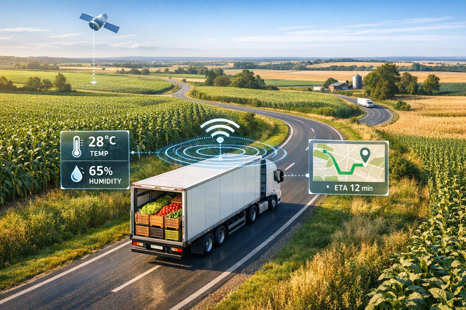
Digital twins are virtual models of transport networks that use real-time data to solve common crop transport challenges like wasted fuel, spoilage, and inefficiency. By continuously updating with live inputs - such as GPS, weather, and sensor data - digital twins help optimize truck routes, improve load efficiency, and reduce delays. Early adopters have reported 4–5% cost savings and 5–10% lower fuel use per ton-mile.
Key Takeaways:
- Problem: Inefficient transport leads to wasted fuel, spoilage, and higher costs.
- Solution: Digital twins optimize routes, schedules, and cold-chain logistics in real-time.
- Results: Up to 30% lower resource use and 20% higher yields for some users.
This technology helps farmers and shippers cut costs, reduce emissions, and maintain crop quality by simulating and refining transport operations.

4-Step Process to Implement Digital Twins for Sustainable Crop Transport
Digital Twins in Agriculture: A Game-Changer for Supply Chains
Step 1: Define Your Digital Twin Scope
To tackle transport inefficiencies with digital twins, the first step is defining the scope of your model. This ensures the solutions align with your operation's specific needs.
Set Measurable Goals
Start by establishing clear, measurable targets for sustainability. For example, aim to cut fuel consumption per ton-mile by 10–20%, reduce CO₂ emissions by 15%, or lower spoilage rates by 25% through smarter routing. These goals aren’t just theoretical - there are real-world successes to draw from. Farms using digital twins have reported a 30% reduction in resource use while boosting yields by up to 20%. Waste Management offers another compelling example: in 2023, they used a digital twin to optimize truck routes, slashing transportation costs by 4% and achieving nearly perfect first-tender acceptance rates. Whether your focus is on on-time-in-full (OTIF) delivery, minimizing deadhead miles, or cutting refrigeration energy costs, set performance indicators that matter most to your operation.
Map Your Transport Network
Next, create a detailed map of your transport network. This includes physical components like fields, roads, storage facilities, processing plants, and vehicles such as trucks and refrigerated trailers. Tools like GPS, drones, and LiDAR can collect geospatial data to capture critical details - elevations, traffic patterns, and bottlenecks. But this isn’t just about drawing static lines on a map. A digital twin creates a dynamic, real-time model that reflects actual conditions. Cloud platforms play a key role here, enabling live updates from IoT devices so your digital twin stays in sync with your physical assets. In fact, studies show that digital twin and spatial analysis platforms can speed up infrastructure inspections by as much as 75% compared to manual methods.
Choose Which Factors to Model
Decide which variables are essential to track for sustainability. Focus on areas like fuel consumption, emissions, refrigeration energy, spoilage risks, weather impacts, and vehicle load efficiency. For operations dealing with perishable goods, cold-chain variables are especially critical - temperature swings during transit can ruin an entire shipment. Adding weather data into the mix helps you anticipate delays caused by storms or extreme heat, while load efficiency modeling ensures trucks operate at capacity. According to McKinsey, supply chains that use predictive modeling for carrier performance have seen 5% reductions in last-mile costs and 10% labor savings. Start by modeling the most impactful variables, and as your system matures, expand to include additional factors. With the scope clearly outlined, the next step is to establish a strong data foundation.
Step 2: Build Your Data Foundation
Once you've defined the scope of your digital twin, the next step is gathering the right data. The accuracy of your digital twin depends entirely on the quality of the information it’s built upon. That means you’ll need detailed, high-quality datasets that cover your crops, fields, transport infrastructure, and the environmental factors influencing them.
Collect Crop and Field Data
Start by gathering key crop data such as GPS coordinates, yield estimates, harvest schedules, and specific handling requirements. Drones equipped with high-resolution cameras, LiDAR, and multispectral sensors can capture detailed imagery and data, enabling precise simulations of harvest timing and volumes. Real-time tracking tools, like farm management software or IoT sensors, can also provide valuable insights. Organize all this information in structured formats like CSV files or cloud-based databases for easy access and analysis. Stick to imperial units - acres for field sizes, bushels for yield - and use the MM/DD/YYYY date format to maintain consistency. To get a full picture, pair this data with details about your transport infrastructure.
Add Transport and Infrastructure Data
Your digital twin should also map out how crops move from the fields to their final destination. This means collecting data on vehicle specifications, such as truck capacity (measured in tons), engine types, and fuel efficiency (miles per gallon under load). Use GPS to map road networks and track routes, and document loading and unloading times at each facility. This transport data can reveal opportunities to cut costs. For instance, optimizing truck routes has been shown to reduce transportation expenses by 4%. Additionally, supply chain models that account for lead times and carrier performance have achieved a 5% reduction in last-mile delivery costs.
Include Weather and Environmental Data
Weather plays a critical role in determining transport schedules, energy consumption, and spoilage risks. Incorporate real-time weather forecasts from sources like NOAA, including data on temperature (°F), precipitation, and wind speed. Historical weather data spanning 5–10 years can help train AI models to predict "what-if" scenarios, such as delays caused by rain or increased refrigeration needs during heat waves. Don’t forget to factor in environmental conditions like road quality and flood risks. When combined with current GPS data, these inputs can help forecast potential disruptions and suggest optimized routes.
A strong data foundation is key to running effective simulations with your digital twin. To simplify the process, platforms like Anvil Labs provide tools for data hosting, processing, and secure sharing. Their integrated solutions can help you bring together diverse datasets, ensuring your digital twin is as accurate and actionable as possible.
sbb-itb-ac6e058
Step 3: Optimize Transport with Your Digital Twin
With your data foundation set, it’s time to put your digital twin to work. By simulating different transport scenarios, you can pinpoint the most efficient options for moving your goods. This means finding ways to cut costs, lower emissions, and keep crops fresh - all while avoiding resource waste. The ability to run these simulations is a game-changer for improving efficiency across the board.
Run Transport Simulations
A digital twin allows you to simulate transport scenarios using real-time data from IoT sensors installed on trucks. These sensors track key metrics like location, temperature, and cargo status. By testing different routes, vehicle assignments, and schedules under conditions such as weather delays or traffic, you can identify the most efficient plan.
For example, Waste Management uses a digital twin system to optimize truck routes, balancing network flows up to 30 days in advance. This approach fine-tunes truck loads and lane assignments, reducing fuel consumption and boosting productivity - results that crop haulers can also achieve. By running multiple scenarios at once, you can determine the best route before committing resources.
Reduce Fuel Use and Emissions
Once you’ve identified the best routes, compare their fuel and emissions profiles. A digital twin models variables like vehicle load, distance, speed, and environmental factors such as headwinds or elevation changes. Key metrics like fuel consumption, CO₂ emissions, route distances, and idle times can all be monitored.
Research shows digital twins can cut resource usage by up to 30% while minimizing environmental impact. In one case, optimizing truck routes with a digital twin reduced transportation costs by about 4%, achieved nearly 100% first tender acceptance rates, and lowered volatility by 60%. These insights help you make greener and more cost-effective decisions.
Improve Cold-Chain Efficiency
For crops like lettuce, strawberries, or tomatoes, keeping the right temperature during transport is crucial. A digital twin can simulate refrigerated transport by factoring in energy use, cargo temperature, route duration, weather, and refrigeration performance. This allows you to optimize transport conditions to reduce spoilage and cooling costs.
Key inputs include sensor data on cargo temperature, humidity levels, and spoilage thresholds - many perishable items need to stay between 32–40°F to remain fresh. By running predictive simulations that account for route times and weather forecasts, you can find the most energy-efficient settings while maintaining safe temperatures. Farms using digital twins for cold-chain logistics have seen resource usage drop by 30% and yields increase by up to 20%. This approach not only ensures produce quality but also supports a more sustainable transport strategy.
Step 4: Integrate and Scale Your Digital Twin
Make the Digital Twin Part of Daily Operations
To truly benefit from a digital twin, it needs to be a part of your team's daily routine - not just something used for occasional projects. Start by incorporating it into your morning meetings. Use the dashboard to review key details like recommended truck loads, estimated fuel usage, and potential weather or road delays that could disrupt deliveries. Compare predictions with actual results by tracking metrics such as miles driven, fuel efficiency (measured in fuel per ton-mile), on-time delivery rates, and cold-chain compliance. These regular check-ins allow you to identify issues early and continuously refine the model, improving its accuracy over time. As the team sees the twin consistently delivering actionable insights, their trust in its recommendations will grow, encouraging them to rely on it more. Once the daily process proves its worth, you can expand its use to cover all aspects of the supply chain.
Extend the Digital Twin Across the Supply Chain
After stabilizing daily operations, you can broaden the digital twin's scope to encompass the entire supply chain. For example, start modeling storage facilities by monitoring inventory levels, storage temperatures, and dwell times. Then move on to processing plants, factoring in throughput limits, shift schedules, and potential yield losses. This ensures your transportation plans align with real capacity constraints. Finally, include distribution centers and retail customers, connecting the line-haul and last-mile delivery stages to track total time-and-temperature exposure. Building this system in stages is key - trying to model everything at once can make it overly complicated and difficult to manage. By integrating these components step by step, you'll improve efficiency, minimize energy waste, and align with broader sustainability objectives.
Facilitate Secure Data Sharing
To fully realize the potential of your digital twin, you’ll need to share data with key partners, such as carriers, co-ops, processors, and retailers. However, data sharing must be done securely. Implement role-based access controls so that each partner only sees the information they need. For instance, internal planners might access detailed operational and cost data, while external haulers would only view loading schedules and delivery windows. This approach safeguards sensitive information while still enabling effective collaboration. Secure data exchange also helps prevent operational errors that could lead to waste.
Anvil Labs offers a cloud platform designed for secure collaboration. It allows teams to host and share diverse visual data - such as 3D models, LiDAR scans, thermal images, and 360° photos. This enables partners to work together on identifying and solving operational challenges without needing on-site visits. For example, teams can annotate problem areas like congestion points or temperature hotspots and share these insights with partners. The platform's role-based viewing ensures that logistics teams, engineers, and sustainability experts can collaborate on solutions - like redesigning traffic flows or optimizing dock assignments - without exposing sensitive details. This spatial, visual approach helps everyone involved better understand physical constraints, making it easier to streamline truck movements, reduce idling, and cut down on energy waste across the network.
Conclusion: Measure Results and Keep Improving
Track Key Metrics
Once you've optimized your simulations and made real-time adjustments, it's crucial to measure the outcomes using clear, actionable metrics. Focus on key indicators like fuel per ton-mile (calculated as total fuel consumed divided by tons transported times miles traveled), emissions per shipment (expressed in CO₂ equivalents), and spoilage rates for perishable goods. For example, track monthly fuel per ton-mile against your baseline - optimized networks often achieve reductions of 20–30%. This could mean dropping from 0.5 gallons per ton-mile to 0.35 gallons. For emissions, integrate data from vehicle telemetry and cargo weight, using standard conversion factors (e.g., 10 pounds of CO₂ per gallon of diesel). Spoilage can be monitored by comparing the percentage of cargo lost before and after implementing your digital twin system. Farms leveraging this technology have reported using 30% fewer resources while boosting yields by as much as 20%.
Balance Cost and Efficiency
Transport decisions often require balancing cost, speed, and environmental impact. Digital twins allow you to run "what-if" scenarios to evaluate these trade-offs before making changes. For instance, you can assess whether a slightly faster but more fuel-intensive route could significantly reduce spoilage, or if a slower route might cut emissions without inflating costs. By displaying metrics like cost per delivery, fuel efficiency, and on-time performance side by side, you can make informed decisions that align with your goals.
Update and Expand Your Model
To keep your digital twin accurate and effective, it’s essential to feed it fresh data regularly. Incorporate real-time inputs like weather forecasts, IoT sensor readings, and storage conditions to account for temperature shifts and other variables. Run advanced scenarios every quarter to simulate disruptions or test alternative fuels and vehicle options. With AI and machine learning, you can generate hundreds of realistic simulations annually, fine-tuning predictions for optimal loading times and cold-chain performance. By continuously updating and refining your model, you'll spot inefficiencies faster and make smarter decisions that cut costs and reduce environmental impact. Keeping your digital twin up to date ensures it remains a powerful tool for improving the sustainability of crop transport.
FAQs
How can digital twins help make crop transport more fuel-efficient?
Digital twins are transforming crop transport by enhancing fuel efficiency. These virtual models simulate logistics to pinpoint the best routes, schedules, and load distributions. With this data, real-time adjustments can be made to reduce fuel consumption and lower emissions.
By factoring in elements like traffic flow, weather conditions, and vehicle performance, digital twins support smarter decisions. This approach not only trims waste but also promotes more efficient and environmentally conscious transportation practices.
What data is essential for creating a digital twin to improve crop transport?
To create a reliable digital twin for crop transport, you’ll need a mix of detailed spatial and visual data. This can include 360° panoramic images, thermal imaging, orthomosaic maps, LiDAR scans, and point cloud data. These elements work together to build precise models that streamline logistics, cut down fuel usage, and lessen the impact on the environment.
How do digital twins make transporting perishable crops more efficient and sustainable?
Digital twins are transforming cold-chain logistics for perishable crops by providing real-time tracking of critical conditions such as temperature, humidity, and other factors during transit. This constant monitoring allows for early detection of potential problems, helping to reduce spoilage and ensure the crops maintain their quality.
On top of that, digital twins enhance route planning, aiming to lower fuel usage and shorten transit times. This not only reduces emissions but also helps cut overall transportation costs. By improving efficiency and minimizing waste, digital twins are reshaping how perishable crops are transported, making the process smoother and more resource-conscious.
