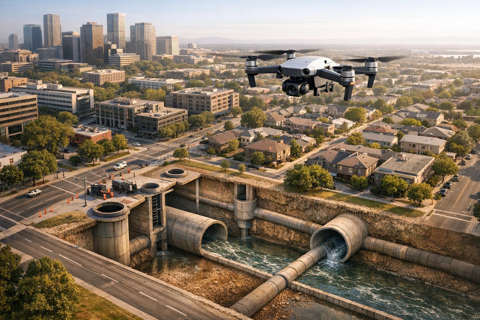
Drones are transforming how sewer systems are inspected, making the process faster, safer, and more cost-effective. Traditional methods are slow, hazardous, and expensive, often requiring large teams and extensive equipment. In contrast, drones equipped with advanced cameras, LiDAR scanners, and AI-powered tools can inspect up to 900 meters daily, cutting costs by 40% and reducing inspection time significantly.
Key benefits include:
- Safety: Workers avoid hazardous environments like confined spaces and toxic gases.
- Speed: Inspections are completed in minutes instead of days.
- Cost Savings: Expenses are reduced by up to 50%.
- Data Quality: High-resolution imagery and 3D models provide detailed insights.
For example, Macomb County, Michigan, reduced inspection costs from $1 million every three years to $100,000 using drones, while delivering faster and more accurate results. Drones like the Flyability Elios 3, equipped with collision-tolerant designs and advanced sensors, are enabling municipalities to manage aging infrastructure more efficiently and prevent costly failures.
This shift is not just about improving processes but also about creating smarter, long-term solutions for infrastructure maintenance.
Drone sewer line inspection and mapping with the Elios 3. Sewer Inspection Camera
Project Objectives and Initial Obstacles
In May 2024, Macomb County Public Works in Michigan embarked on a mission to modernize their sewer inspection program. Operations Director Vince Astorino set three key goals: remove workers from hazardous environments, reduce data processing times from weeks to hours, and obtain highly detailed data that traditional methods couldn't achieve. The county had been spending almost $1 million every three years on manual inspections, which required teams to navigate dangerous underground networks. However, these ambitious goals quickly ran into the limitations of conventional inspection techniques.
The hurdles were substantial. Traditional inspections required workers to physically enter sewer lines, where explosive gases could accumulate. This process alone demanded over two hours of gas monitoring before entry. Such challenges aren't unique to Macomb County. In Plymouth, UK, Glanville Geospatial faced similar issues in September 2022 while surveying the tunnel network beneath The Barcode in the city center. These tunnels, largely untouched since construction, were deemed too dangerous for human access due to potential structural defects.
"A drone inspection represented a significant opportunity to collect high-resolution survey data on otherwise inaccessible critical assets, without the need to deploy a confined space team and therefore eliminating the human exposure to hazardous environments." – Glanville Geospatial
Urban infrastructure presented additional complications. Factors like narrow pipelines, flowing water, unstable airflows, and total darkness made it nearly impossible for conventional tethered CCTV equipment to operate effectively. For instance, in Toronto, WSP Global Inc. needed to inspect a 3,000mm diameter combined sewer that housed a smaller pipe inside. Located 295 feet underground beneath a busy highway on-ramp, the project required extreme precision to ensure a new shaft would align perfectly with existing pipes.
These challenges highlighted the pressing need for drone-powered inspections and advanced digital mapping technologies. For Macomb County, the goal was to adopt a system capable of delivering detailed reports - including 3D models, LiDAR scans, thermal imaging, and gas readings - all while keeping workers safely above ground and drastically cutting inspection times.
Drone Technology and Workflow
To tackle the dangers of hazardous and confined spaces, the Flyability Elios 3 was chosen for its unique design and capabilities. Its collision-tolerant cage and ability to operate without GPS make it ideal for challenging environments. Equipped with a centimeter-accurate LiDAR scanner, a 4K RGB camera, thermal sensors for detecting leaks, and tools to monitor 14 hazardous gases - including hydrogen sulfide - this drone met the rigorous demands of the job. Key criteria for selection included achieving survey-grade accuracy (20 mm), minimizing human risk, and collecting comprehensive data in a single flight.
Site Preparation and Equipment Setup
Before deploying drones into sewer systems, teams followed strict safety protocols. For instance, during Glanville Geospatial's project in Plymouth in September 2022, crews at multiple shaft locations ventilated tunnels and checked gas levels to ensure safe conditions. This level of coordination was critical, especially for long tunnel sections where maintaining proper airflow and monitoring atmospheric conditions was vital.
Georeferencing was another significant hurdle. To align underground data with surface maps, teams like Team UAV combined above-ground photogrammetry with underground LiDAR scans in May 2024. Tools such as the Leica RTC 360 terrestrial laser scanner and Trimble S7 total stations were used to create "inverted scans" at manholes. These scans provided the overlap needed to accurately map culverts in relation to roads and buildings. Mark Anderson, Co-director at Academy Geomatics, highlighted the precision achieved:
"We found our Elios 3 point cloud in this project was just 20 millimeters off the terrestrial laser scans, which is a very good result and, in the context of this project, meets survey-grade requirements".
Once safety measures were confirmed and georeferencing was completed, the team was ready to begin the survey.
Survey Execution Process
With all safety checks in place, drone pilots began the survey in a structured manner. The process started with a 4K scouting flight to identify any structural concerns. Afterward, the drone's LiDAR system was activated to generate detailed 3D point clouds. In a spring 2025 project for Northumbrian Water, Academy Geomatics surveyed a 60-meter (approximately 197 ft) sewer pipe - including a 10-meter (approximately 33 ft) vertical descent - in just half a day with a two-person crew. By comparison, traditional methods would have taken three days and required a standby rescue team.
The drone’s collision-tolerant design proved invaluable in tight spaces. Pilots maneuvered through pipes as narrow as 24 inches in diameter, with the drone safely making contact with walls without risking damage. LED lights illuminated the dark tunnels, while Wi-Fi ensured connectivity up to 200 meters (approximately 656 ft) from entry points. At the Plymouth site, the drone successfully surveyed 400 meters (approximately 1,312 ft) across two tunnel sections, with one segment exceeding 200 meters (approximately 656 ft) in length.
Data collected during the flights was immediately processed using software like FARO Connect and WinCan Web. This allowed teams to view 4K footage alongside 3D point clouds, enabling precise identification of defects. These high-resolution datasets seamlessly integrated into advanced workflows for further analysis.
Data Processing and Integration with Anvil Labs
After the drone survey was completed, the raw data was transformed into actionable insights. LiDAR point clouds were first imported into specialized software like Inspector 5 and FARO Connect for initial filtering. To achieve the precision needed for survey-grade accuracy, these drone-generated point clouds were combined with terrestrial laser scans captured by the Leica RTC 360. Using CloudCompare, this data was merged into a seamless 3D model that extended from surface manholes to underground pipes.
RGB imagery was processed using 3Dsurvey to create dense point clouds, digital surface models (DSM), and high-resolution orthophotos. At the same time, thermal imaging data was analyzed to identify anomalies such as leaks or areas of heat loss. Once processed, all datasets were exported into widely-used formats like .las and .dxf, ensuring compatibility with CAD software and cloud-based systems. These unified datasets were then integrated into a centralized management system for further use.
Anvil Labs played a key role in managing and hosting this extensive data. The platform turned raw LiDAR and imagery data into interactive 3D models and digital twins, creating a "digital sandbox" where engineers could plan and analyze projects. Through Anvil Labs' web portal, stakeholders could navigate sewer infrastructure models, take precise measurements, and add annotations directly onto the 3D visualizations.
With its advanced annotation tools, the platform allowed teams to mark defects, measure distances, and calculate volumes - all without needing to revisit the site. This real-time collaboration, combined with centralized and securely shared project data, streamlined workflows compared to traditional methods. The integration highlights a shift toward safer, faster, and more accurate infrastructure management.
sbb-itb-ac6e058
Results and Key Metrics
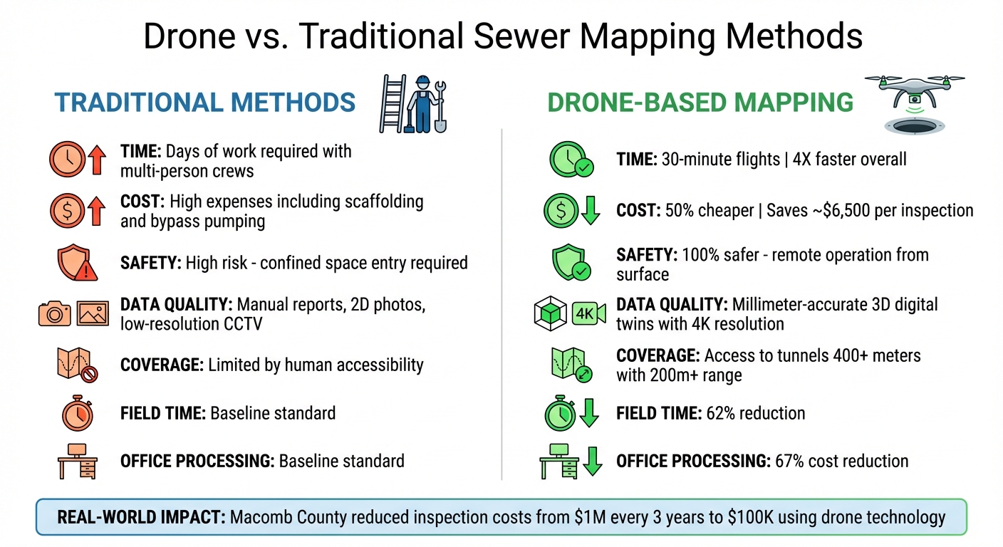
Drone vs Traditional Sewer Mapping: Cost, Time, and Safety Comparison
The operational improvements discussed earlier translated directly into impressive results, focusing on faster, safer, and more cost-efficient inspections. The project achieved a significant reduction in survey time, cutting it down from several days to just a 30-minute drone flight. This single flight successfully mapped 400 meters of tunnel, including a continuous stretch exceeding 200 meters.
In addition to saving time, this approach greatly improved worker safety. By eliminating the need for confined space entry, the project ensured 100% safer operations. Workers could remain safely at surface entry points while the drone navigated hazardous underground areas. This completely removed human exposure to toxic gases and biological risks, which had previously rendered parts of the tunnel network inaccessible since its construction.
The cost savings were equally impressive, with overall expenses reduced by 50%. Field time was cut by 62%, office processing time by 67%, and approximately $6,500 was saved per major asset inspection. Costly requirements like scaffolding, bypass pumping, and multi-person confined space crews were no longer necessary.
The drone technology also delivered exceptional data quality. High-resolution 4K imagery and millimeter-accurate 3D point clouds allowed for precise defect detection. Will Bianchini from the Onondaga County Water Authority highlighted the efficiency of this approach:
"Even the largest tanks in our distribution system can be captured in under 20 minutes with 100+ HD images capturing every square inch of the asset."
Drone vs. Traditional Methods Comparison
The table below highlights the stark differences between traditional sewer mapping methods and the drone-based approach.
| Metric | Traditional Sewer Mapping | Drone-Based Mapping |
|---|---|---|
| Time | Days of work for multi-person crews | 30-minute flights; 4X faster overall |
| Cost | Requires scaffolding, bypass pumping | 50% cheaper; saves ~$6,500 per inspection |
| Safety | High risk; confined space entry required | 100% safer; remote operation from surface |
| Data Quality | Manual reports, 2D photos, low-res CCTV | Millimeter-accurate 3D digital twins, 4K resolution |
| Coverage | Limited by human accessibility | Accesses tunnels 400+ meters; over 200m range |
| Field Time | Baseline | 62% reduction |
| Office Processing | Baseline | 67% cost reduction |
This comparison clearly demonstrates how drone technology outperforms traditional methods in nearly every key area, making inspections faster, safer, and more efficient.
Benefits and Future Applications
Drones are not just boosting safety and efficiency - they’re reshaping how municipalities handle long-term maintenance and infrastructure planning. By collecting and analyzing data over time, drone technology is making municipal management smarter and more proactive.
The efficiency gains alone are impressive. Take Academy Geomatics in the UK, for example. Using the Elios 3 drone, they can now survey four large manholes in a single day - four times faster than with traditional tools. Plus, they’ve eliminated the need for rope access and standby rescue teams. Mark Anderson, co-director at Academy Geomatics, put it this way:
"The drone allows us to get data quickly and safely, massively cutting down on the time we need for rope access as well as costs for having rescue teams on standby. We can survey 4 large manholes in a day with the Elios 3, compared to just 1 using traditional surveying tools".
The benefits don’t stop at speed and cost savings. Drones are enabling predictive maintenance, helping municipalities shift from reacting to emergencies to addressing problems before they escalate. For instance, Macomb County invested $100,000 in drone and AI technology, replacing a system that previously cost $1 million every three years. This new setup allows them to document 1,000 feet of pipe in just 20 minutes, with AI delivering analysis within 24 hours. By spotting cracks and soil ingress early, they’ve significantly reduced the risk of catastrophic failures.
Drones also play a critical role in urban planning. When Toronto needed precise data to construct a new shaft, they used a 3D point cloud of a 560-meter (about 1,840 feet) combined sewer. This allowed them to pinpoint the exact alignment of an encased sanitary pipe 90 feet underground. The survey-grade accuracy - approximately 0.8 inches - met stringent engineering requirements, ensuring that existing infrastructure remained intact during construction. This level of precision integrates seamlessly with urban planning workflows and supports the growing use of digital twins in infrastructure management.
As technology advances, artificial intelligence and machine learning are further enhancing predictive capabilities. Vince Astorino, Operations Director at Macomb County Public Works Office, highlighted the effectiveness of SewerAI software:
"We performed months of testing against coded video in the field... and every single time SewerAI excelled in what it was able to find and code correctly".
With drone use in the utility sector expected to grow sevenfold between 2022 and 2030, it’s clear these tools are becoming indispensable for managing aging infrastructure across the U.S. From cutting costs to improving precision, drones are setting a new standard for infrastructure management.
Conclusion
Anvil Labs is revolutionizing sewer mapping with its drone technology. What used to take an entire day and a team of operators can now be done in under an hour. The results? 85% faster deliverables, 50% lower costs, and 100% safer operations by eliminating the need for confined space entry. At the core of this transformation is the accuracy and accessibility of the data: millimeter-precise digital twins create permanent records that engineers can access remotely, measure with precision, and monitor over time to catch potential issues before they escalate.
These advancements don’t just improve efficiency - they open the door to smarter, long-term strategies. Matt Barrington from EY highlights the broader implications:
"With the deeper and more contextualized insights digital twins provide, we gain a better understanding of our products, processes, and systems and more confidence in our models".
This increased confidence leads to better planning, more informed maintenance decisions, and stronger, more resilient infrastructure. It’s a shift that supports scalable solutions designed to meet future challenges.
Anvil Labs’ FAA Part 107-certified pilot network enables rapid deployment across large areas. Whether it’s an urgent inspection or a full-scale network survey, the system handles projects of any size with precision, maintaining data accuracy within ±0.5% error margins.
FAQs
How do drones enhance safety during sewer inspections?
Drones play a crucial role in enhancing safety by removing the necessity for inspectors to venture into hazardous sewer systems. These environments often pose serious risks, including exposure to toxic gases, fast-moving water, biohazards, and the danger of structural collapses.
With drones, inspections can be carried out remotely, allowing for a safer, more efficient process that significantly reduces risks to human health and well-being.
What technologies do drones use for sewer mapping?
Drones designed for sewer mapping use cutting-edge sensing technologies to gather precise and detailed information about underground infrastructure. These drones are often equipped with high-resolution cameras that can record 4K video and capture 12-megapixel images. This level of detail is crucial for spotting problems such as cracks, corrosion, or blockages within sewer systems.
Beyond visual imaging, many of these drones come with advanced surveying tools. For instance, GNSS-based positioning systems and georeferencing software help create accurate digital maps of sewer networks. Additionally, sensors like LiDAR, SONAR, and laser profilers are used to measure depth, geometry, and surface details, especially in areas where visibility is limited.
The data collected by these drones is transformed into formats like 3D models, point clouds, and orthomosaics. These outputs can then be securely stored, analyzed, and shared using platforms like Anvil Labs, which provide features for annotation, measurement, and team collaboration.
How do drones help lower the cost of sewer inspections?
Drones are transforming sewer inspections by slashing costs and boosting safety. Unlike traditional methods that require large crews and risky confined-space entry, drones handle the job with fewer resources and less danger. They can complete surveys in just hours, a task that used to take days, reducing planning and inspection time by about 50%.
This streamlined approach not only speeds up the process but also cuts down on labor, equipment, and safety-related expenses, making sewer inspections more efficient and budget-friendly.
