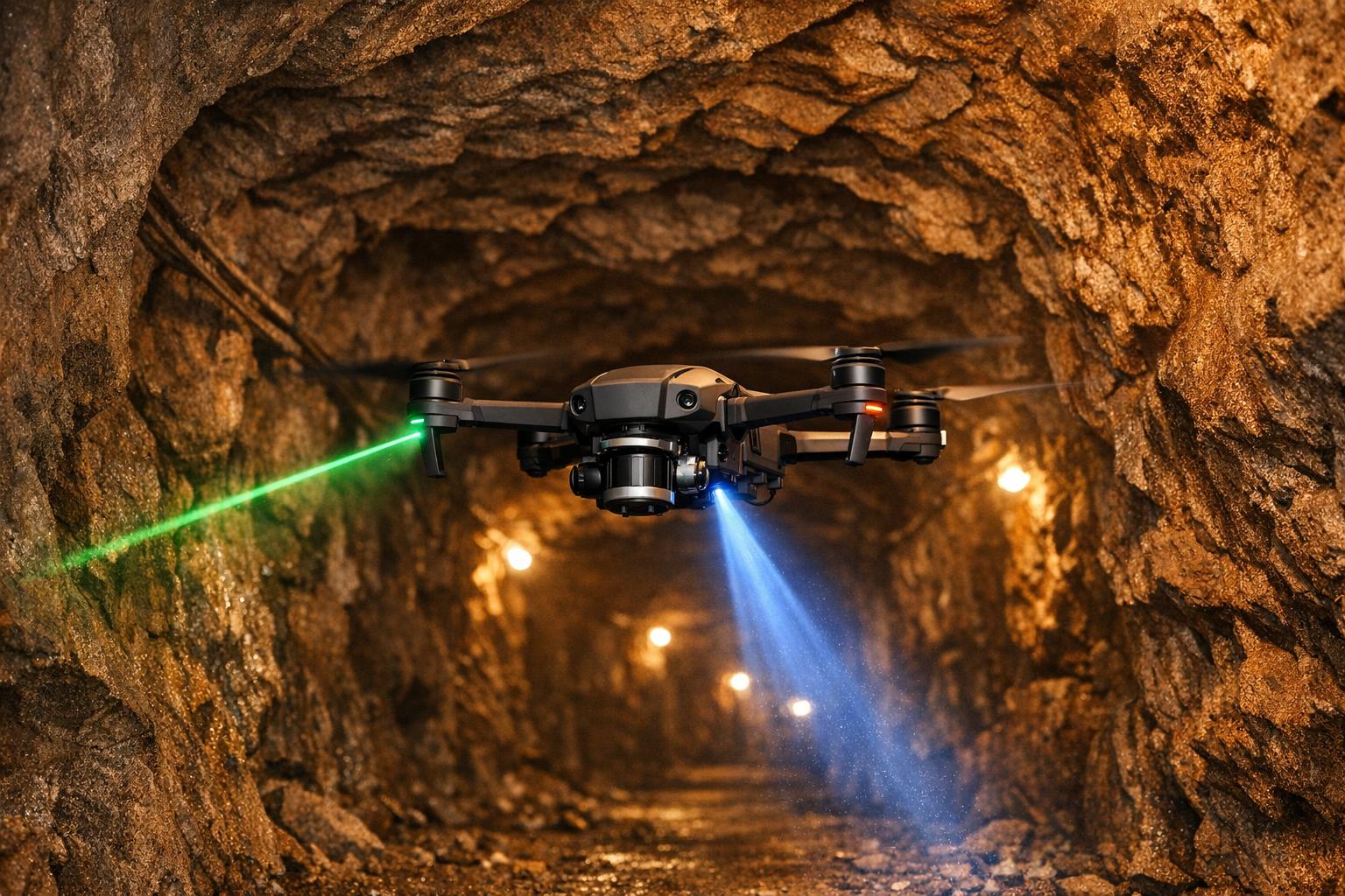
Autonomous drones are transforming underground mining by making it safer and more efficient. These drones use advanced LiDAR-based SLAM technology to navigate dark, hazardous environments without GPS, creating highly accurate 3D maps. Here's why they're a game-changer:
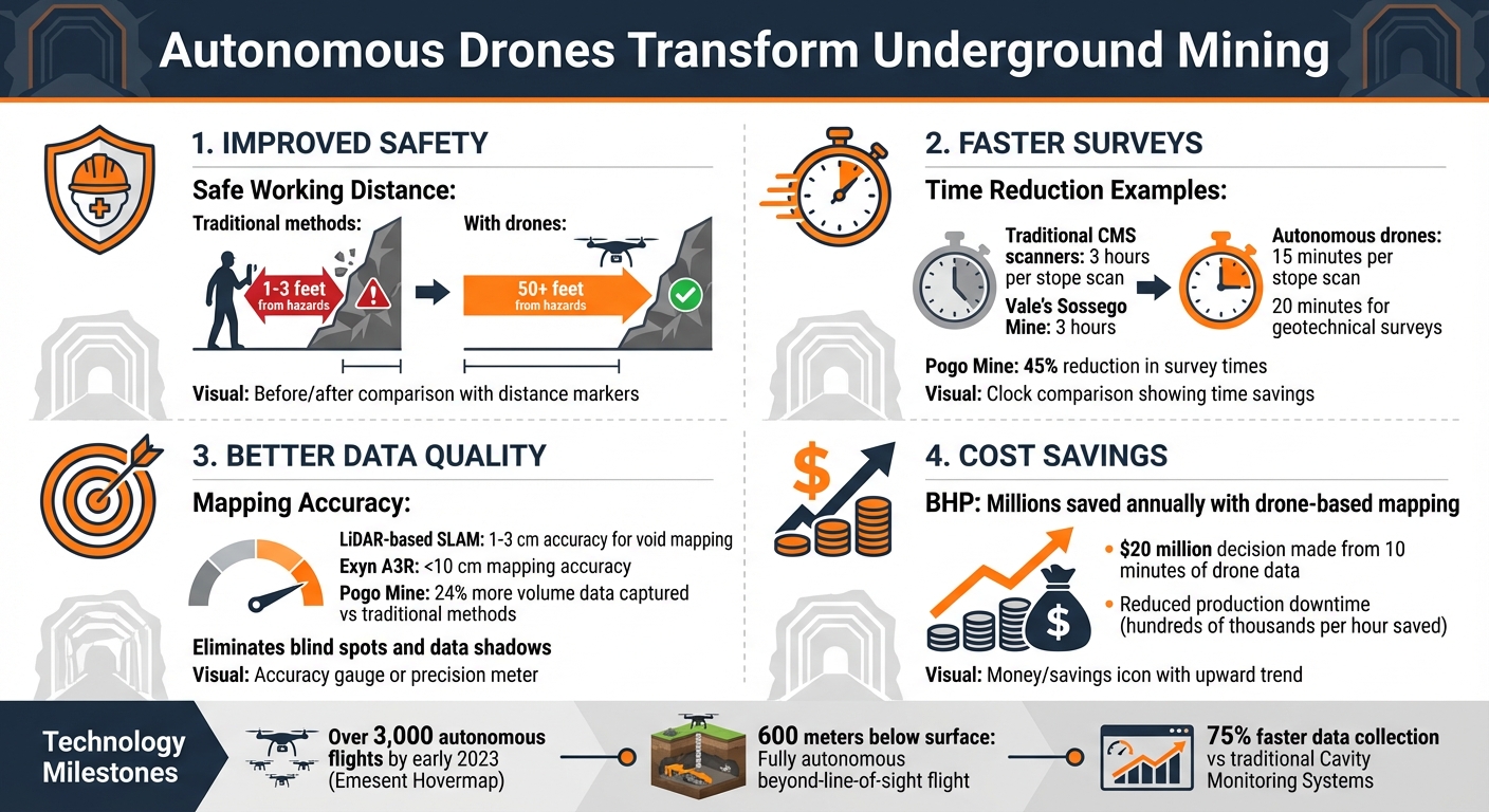
- Improved Safety: Drones extend the safe working distance for miners from 1–3 feet to over 50 feet, reducing exposure to unstable areas.
- Faster Surveys: Mapping tasks that once took hours now take minutes. For example, at Pogo Mine, drones reduced survey times by 45%.
- Better Data Quality: Drones eliminate blind spots in traditional mapping methods, providing detailed void detection and structural hazard identification.
- Cost Savings: Companies like BHP have saved millions annually by switching to drone-based mapping.
These drones rely on LiDAR sensors, SLAM algorithms, and multi-sensor fusion to operate in challenging underground conditions. While challenges like limited flight time and complex environments remain, advancements like foldable drones and improved communication systems are addressing these issues. The future of underground mining could see fully autonomous drones conducting inspections without human intervention, driving safety and productivity to new levels.
Autonomous Drone Benefits in Underground Mining: Key Statistics and Safety Improvements
Using the Exyn Nexys Autonomous SLAM UAV in Underground Mines

Technologies That Power Underground Mapping Drones
Underground mapping drones are transforming safety and efficiency in challenging environments. In places where GPS signals can't penetrate, drones rely on SLAM (Simultaneous Localization and Mapping) technology. This system enables drones to figure out their position while simultaneously building a map of the unknown terrain - essentially creating a navigational map in real time.
LiDAR sensors play a critical role as the "eyes" of these drones in underground spaces. By emitting laser pulses and measuring the time it takes for the reflections to return, LiDAR generates instant 3D models of the surroundings. To put this into perspective, autonomous LiDAR drones can complete a stope scan in just 15 minutes, compared to the 3 hours required by traditional CMS scanners. By early 2023, Emesent's Hovermap technology had powered over 3,000 autonomous flights, including an unprecedented fully autonomous, beyond-line-of-sight flight 600 meters below the surface.
Navigation Without GPS
Navigating underground comes with its own set of challenges, especially in environments filled with darkness, dust, and smoke, which can degrade sensor performance. To tackle this, drones combine data from multiple sources - such as LiDAR, inertial measurement units (IMU), and thermal or visual cameras. This fusion ensures reliable navigation even in the harshest conditions. When visibility is poor or other sensors struggle, the IMU steps in to provide velocity and orientation data, while thermal cameras help detect cues in low-visibility settings.
In July 2020, Emesent achieved Level 2 Autonomy (AL2) for its Hovermap system. This milestone allowed drones like the DJI Matrice 300 RTK to autonomously navigate and avoid obstacles, even when operating beyond the operator's line of sight.
"This is a huge step forward for drone autonomy and a massive benefit to industries like mining, civil construction, and emergency response. With the intelligence to navigate environments without a prior map, customers can use the system to carry out complex missions."
- Dr. Stefan Hrabar, CEO and Co-founder of Emesent
To enhance navigation further, advanced systems use Model Predictive Control (MPC) for precise trajectory tracking and algorithms designed for collision-free exploration. These technologies are especially effective in narrow, textureless, or self-similar underground spaces where standard visual positioning systems often fail. Together, these advancements create a seamless integration of navigation and mapping capabilities.
Sensors Used for Underground Mapping
Underground mapping drones rely on a combination of sensors, including LiDAR, thermal cameras, ultrasonic sensors, and gas sensors, to navigate and detect hazards while delivering highly accurate 3D maps. For instance, LiDAR-based SLAM can map voids with accuracies of 1–3 cm. Drones like the Exyn A3R achieve mapping accuracies of less than 10 cm thanks to rotating LiDAR sensors.
A notable example of this technology in action was during the DARPA Subterranean Challenge (which wrapped up around 2021). A collaboration between CSIRO Data61, Emesent, and Georgia Tech showcased Wildcat SLAM technology, mapping complex underground environments like a coal mine near Pittsburgh and an uncommissioned nuclear power station. Their efforts earned them the "Single Most Accurate Report" award.
This sophisticated sensor integration not only ensures precise mapping but also provides reliable data for further analysis, setting the stage for improved underground operations.
How Autonomous Drones Are Used in Underground Mining
Creating 3D Maps and Detecting Voids
Autonomous drones are transforming underground mining by offering precise mapping and hazard detection capabilities. These drones generate high-density 3D point clouds, collecting thousands of data points every second. The data is processed into survey-grade models that reveal crucial details like voids, weak structures, and blockages in mining tunnels.
Take the Pogo Mine in Northern Nevada, for example. A study by USCCG and Exyn Technologies found that the ExynAero drone reduced underground survey times by 45% while capturing 24% more volume data compared to traditional methods. Tasks that once took surveyors three hours using traditional Cavity Monitoring Systems (CMS) now take just 15 minutes with autonomous drones.
Traditional boom-mounted scanners often leave "shadows" or blind spots in the data. In contrast, drones can fly deep into voids, capturing uniform, high-resolution data from every angle. At Mount Isa Mines (Glencore), surveyors using Emesent Hovermap eliminated data shadows entirely, achieving accurate void volume measurements. A senior surveyor highlighted this advantage:
"The Hovermap has given us the flexibility to deploy the scanner further into the void to help us remove all of the shadows. We've got the true void volume... Changing to the Hovermap moves us to the next level of safety by taking us further away from the hazards".
These advanced technologies not only enhance mapping accuracy but also improve safety and operational workflows.
Improving Mine Safety and Efficiency
The impact on safety is immediate and measurable. Traditional surveys often require personnel to work dangerously close - within 1–3 feet - of hazardous brows (stope edges). Autonomous drones, however, allow operators to stay over 50 feet away from these risks while collecting even more precise data.
"Autonomous drones are a real game changer for risk management and data collection."
- Patti Pegues, Mine Planning Manager, Vale North America
The efficiency gains are equally impressive. At Vale's Sossego Mine in Para, Brazil, geotechnical surveys that used to take three hours now take just 20 minutes. These drones also enable inspections to occur without halting production, avoiding the costly shutdowns that traditional visual inspections often require.
sbb-itb-ac6e058
Managing and Using Drone Data
Processing and Storing 3D Data
Autonomous drones have revolutionized how raw LiDAR data is processed, turning it into actionable insights with incredible speed. Tools like Exyn Nexys allow survey teams to process data directly on a tablet as soon as the drone returns. This means teams can review the results while still underground, cutting out the frustrating delays that were common with older workflows.
Using SLAM algorithms, these systems transform sensor data into high-resolution point clouds and generate industry-standard .las files with UTM projections. Automated workflows for ground control points (GCPs) further streamline the process by detecting mining adaptors and prisms during scanning, eliminating the need for manual georeferencing.
Once the data is processed, it seamlessly integrates with mining platforms like Deswik.CAD and Maptek PointModeller. These platforms quickly convert point clouds into practical outputs such as surfaces, solids, and CAD models, all in a matter of minutes.
Using Anvil Labs for Data Visualization and Collaboration

After processing, the next step is making the data accessible and useful for decision-making and collaboration. Mining operations require a centralized platform to manage and visualize large 3D datasets across teams, and Anvil Labs delivers just that. This platform supports a variety of data types, including LiDAR point clouds, 3D models, thermal imagery, and orthomosaics - all commonly generated by mapping drones.
With tools for annotations and measurements, Anvil Labs enables mining teams to perform tasks like volumetric calculations, convergence monitoring, and geotechnical stability analysis directly within the 3D environment. Its cross-device compatibility ensures seamless access - engineers can examine stope data underground on tablets, while planning teams evaluate the same models from their surface offices.
To facilitate secure collaboration, the platform includes access controls, ensuring sensitive mine data is shared only with authorized personnel. Additionally, integration with AI analysis tools and task management systems allows mining operations to automate workflows, such as identifying potential hazards or deviations from planned excavation profiles. By combining powerful visualization tools with advanced automation, Anvil Labs helps mining teams stay efficient and safe.
Challenges and Future Developments
Current Limitations
Autonomous drones face several significant hurdles when operating in underground mines. One of the biggest challenges is their limited flight time - most drones can only stay airborne for 10 to 20 minutes before requiring a recharge. Adding heavier sensors to improve data collection only exacerbates this issue, forcing operators to choose between covering more ground or gathering higher-quality data.
The underground environment itself presents unique difficulties. Total darkness, thick dust, and smooth rock walls diminish the performance of sensors, making navigation far more complex. The intricate and branching structure of mine shafts blocks wireless signals, meaning drones often have to function without real-time communication.
Accessing critical areas within mines is another obstacle. Narrow boreholes require drones that can fit through tight spaces and then expand to full operational size. Once inside, drones encounter hazards like dangling cables, stalactites, and remnants of old infrastructure - all of which can shift unexpectedly when air currents are disturbed by drone activity. Additionally, any equipment used underground must meet strict ATEX safety standards to ensure it can operate in explosive atmospheres, adding layers of complexity and cost to their design.
Despite these challenges, new technologies are emerging to address these issues.
New Technologies on the Horizon
Innovators in the industry are developing solutions to push the boundaries of what drones can achieve underground. A notable breakthrough came in November 2025 with the Prometheus project, which tested the Titan-I drone at Holman's test mine in Cornwall, UK. This drone was designed to compress to just 5.1 inches (130 mm) to fit through standard boreholes and then expand to a 30.7-inch (780 mm) wingspan once deployed. It successfully mapped approximately 1.2 miles (2 km) of granite quarry tunnels autonomously.
Another promising advancement is the integration of multi-modal sensor fusion. By combining technologies like LiDAR, thermal cameras, visual sensors, and Inertial Measurement Units (IMUs), drones can maintain accurate positioning even when individual sensors are compromised by dust or other environmental factors.
Improved communication systems are also making underground operations more feasible. For instance, Elsight's Halo system aggregates up to four separate cellular connections into one secure and reliable link, ensuring uninterrupted connectivity in the complex layouts of mines.
The push for greater autonomy is transforming how drones operate in these environments.
"If there is an incident and they have to halt production, it's costing them hundreds of thousands of dollars per hour, and so the sooner that they can get in, assess the area and resume production, the better."
- Dr. Stefan Hrabar, CEO and Co-Founder of Emesent.
The future of underground drone systems envisions fully autonomous operations, where drones remain permanently underground, conducting routine inspections and monitoring at the press of a button - entirely independent of human intervention.
"A big part of the promise of autonomous robots is in productivity benefits. But if you have one person controlling a robot remotely, that's not necessarily a great gain. There is a great gain, however, if that person can control ten or more robots."
- Jason Williams, Team Leader of Robot Autonomy at CSIRO Data61.
These technological advancements are set to significantly improve the safety, efficiency, and precision of underground mining operations, paving the way for a more streamlined and productive future.
Conclusion
Autonomous drones are changing the game in underground mine mapping, boosting safety and delivering highly detailed 3D data. Using LiDAR-based SLAM technology, these drones can navigate GPS-denied environments and collect data up to 75% faster than older methods like Cavity Monitoring Systems. For instance, at Pogo Mine in Ontario, drones cut surveying times by 45% and extended the safe working distance from hazardous areas from just 1–3 feet to over 50 feet.
The data these drones produce is shadow-free and high-density, offering accurate void volume measurements that drive better decision-making. In one case, a mining company used 10 minutes of drone-captured data to make a $20 million decision. With such impactful results, having a strong platform to manage and share this data is critical.
That’s where Anvil Labs comes in, providing tools to securely host, visualize, and collaborate on drone-collected data, ensuring stakeholders can review it instantly and efficiently.
As mining operations progress toward Level 4 autonomy and fully automated underground systems, the synergy between cutting-edge drone technology and advanced data management platforms will continue to improve safety and streamline operations across the industry.
FAQs
How do autonomous drones operate underground without GPS?
Autonomous drones rely on cutting-edge onboard sensors like LiDAR, cameras, and inertial measurement units (IMUs) to navigate underground. These sensors, combined with SLAM (Simultaneous Localization and Mapping) algorithms, enable the drones to generate a real-time 3D map of their surroundings while pinpointing their position. This capability is crucial for navigating areas where GPS signals are unavailable, such as underground mines.
With these technologies, drones can identify voids, chart intricate spaces, and handle tough environmental conditions, proving to be an essential tool for underground mining operations.
What challenges do autonomous drones face when mapping underground mines?
Underground mining environments pose significant challenges for autonomous drones. One of the biggest issues is the absence of GNSS signals, which makes navigation a daunting task. Without these signals, drones can't rely on conventional positioning systems, and the limited availability of SLAM infrastructure only adds to the difficulty. On top of that, poor lighting and a lack of distinct landmarks make mapping the area even more complex.
The harsh conditions underground don't make things any easier. Factors like dust, high humidity, and fluctuating temperatures can interfere with the performance of sensors and communication systems, compromising the drones' functionality. And of course, ensuring safety and proving that these autonomous systems can operate reliably in such extreme environments remains a major challenge.
How do autonomous drones enhance safety and efficiency in underground mining?
Autonomous drones are transforming safety in underground mining by minimizing the need for workers to venture into dangerous areas. Equipped with advanced technology, they generate real-time, high-resolution 3D maps, allowing teams to spot structural risks and hazards without exposing anyone to harm.
Beyond safety, these drones enhance operational efficiency. They swiftly gather precise volumetric data and keep a constant check on voids and ground conditions. This means quicker decision-making, improved resource allocation, and smoother operations with less downtime.
