3D models are transforming how emergency repairs are planned and executed. Unlike 2D blueprints, 3D models provide detailed, spatially accurate views of facilities, enabling faster, safer, and more precise damage assessments. These models, combined with tools like drones, LiDAR, and photogrammetry, allow teams to remotely evaluate damage, prioritize repairs, and collaborate efficiently. Key benefits include:
- Faster decisions: Teams can analyze damage remotely in hours instead of days.
- Improved safety: Reduces the need for risky on-site inspections.
- Cost efficiency: Accurate data minimizes material waste and labor costs.
- Better collaboration: Digital platforms enable real-time teamwork across locations.
- Preventative maintenance: Routine scans help detect issues early, reducing future repair costs by up to 40%.
With tools like Anvil Labs, teams can manage 3D data, streamline workflows, and document repairs effectively, setting the stage for long-term maintenance planning.
Capturing 3D Data After an Emergency
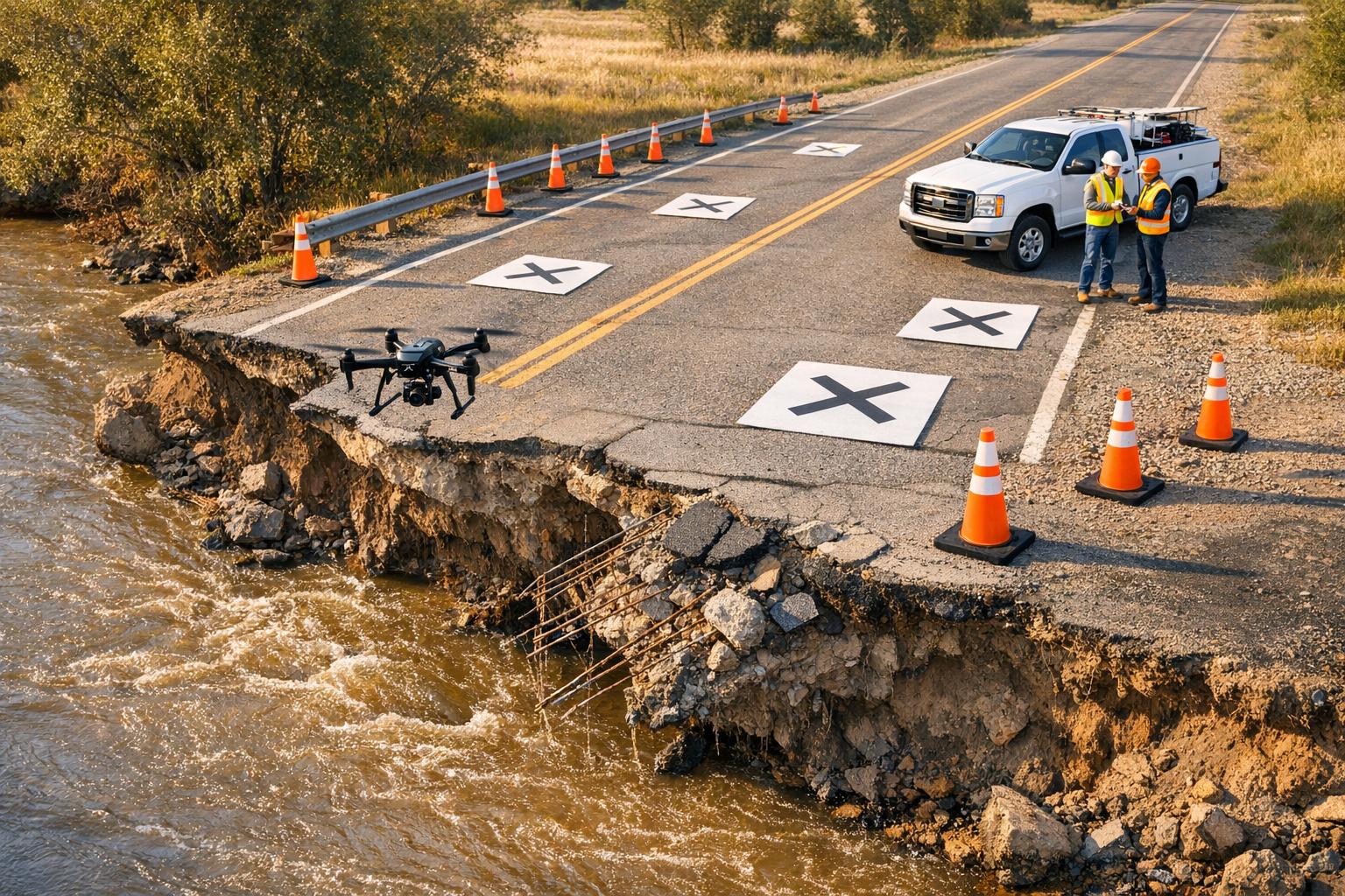
When a disaster strikes, time is of the essence. Teams need to act fast to collect critical spatial data. With the right tools, detailed 3D models can be created in just a few hours, setting the stage for accurate risk assessments and speedy repairs.
Using Drones, LiDAR, and Photogrammetry
Drones equipped with high-resolution cameras or LiDAR sensors are a game-changer for disaster response. These devices can fly over affected areas, capturing overlapping aerial images or point clouds. For example, after Hurricane Ian in 2022, drones helped FEMA create orthomosaic maps with centimeter-level accuracy, enabling quick damage evaluations.
LiDAR (Light Detection and Ranging) is another powerful tool, especially in tough conditions. It uses laser pulses to measure distances and create precise 3D point clouds. Even in environments filled with smoke, dust, or dense vegetation, LiDAR delivers reliable results. During California's 2020 wildfires, it mapped burn scars with sub-inch accuracy at speeds of up to 1 million points per second, allowing teams to focus on the most critical repairs.
Meanwhile, Photogrammetry transforms 2D images from drones, smartphones, or handheld cameras into 3D models by stitching together overlapping photos. After the 2023 Maui wildfires, teams used this method to map 2,000 acres in just 48 hours, documenting 85% of damaged buildings and enabling $500 million in prioritized repairs.
Best Practices for Data Capture
For the best results, attention to detail is key. Images should have enough overlap and be captured at the right altitudes to achieve 2-5 cm resolution. Ground control points - surveyed markers placed across the site - are essential for georeferencing precision within 1 inch. These methods, used during post-Hurricane Helene modeling in 2024, ensure highly accurate data.
Weather conditions play a big role. Rain, high winds above 20 mph, and heavy debris can lower image quality or even cause drone crashes. To avoid these issues, schedule flights during calmer times like dawn or dusk. Use wind-resistant drones, such as the DJI Matrice 300, for added stability. If weather conditions are too harsh, ground-based LiDAR scanners can be a dependable alternative.
Safety is critical. Operators should have FAA Part 107 certification and secure temporary flight waivers for emergency zones. Maintain a clear line of sight with drones and use collision avoidance systems. In hazardous areas, like those with chemical spills, tethered drones or ground robots are safer options. Following these safety measures reduced incidents by 40% during U.S. wildfire responses, according to 2024 NTSB reports.
Once the data is captured, processing should be completed within 24 hours using specialized tools. For example, processing a 500-acre site can take less than 2 hours on cloud GPUs. Platforms like Anvil Labs can then host these 3D models alongside 360-degree photos and thermal imaging. These tools allow for secure sharing, annotations, and easy access across devices, helping repair teams quickly move on to prioritizing damage and assessing risks.
sbb-itb-ac6e058
Risk Assessment and Damage Prioritization with 3D Models

3D Models vs Manual Inspection Methods for Emergency Repairs
Once the 3D data has been captured and processed, the next step is all about prioritizing repairs. Using 3D models, teams can categorize damage severity with precision, thanks to the clear, measurable evidence these models provide. This helps determine what needs immediate attention and what can wait.
Visualizing and Cataloging Damage with 3D Models
3D models turn chaotic disaster sites into organized, searchable databases. Teams can annotate models with color-coded markers - like red for urgent issues and yellow for moderate concerns - and use built-in tools to measure specifics, such as the depth of a crack or the volume of debris.
Take Hurricane Maria in 2017 as an example. Puerto Rico utilities used drone-generated 3D models to map 1,200 miles of downed power lines. By tagging high-priority urban grid sections first, they managed to restore 70% of power in just two weeks - a process that could have taken months otherwise. According to USGS reports, this method slashed assessment time by 75% by quantifying damage volumes.
These models also uncover issues that might go unnoticed in manual inspections. For instance, integrating thermal imaging with photogrammetry can reveal hidden risks, like electrical hotspots or moisture trapped behind walls. In one factory fire case, the cataloging process documented burn damage across 10,000 square feet and flagged roof sections with over 20% charring that needed immediate stabilization. Similarly, LiDAR models, when comparing pre- and post-event data, can highlight structural shifts, such as bridge supports that have moved or foundations that have eroded. One example showed an 80% failure probability in areas with more than 5% deformation.
This thorough cataloging process sets the stage for comparing 3D digital assessments with traditional manual methods.
3D Models vs. Manual Inspection Methods
The contrast between 3D-based assessments and manual inspections is striking. Manual inspections require people to physically enter hazardous areas, introducing safety risks and leaving room for human error. On the other hand, 3D models provide a safer, more accurate, and faster alternative. For example, FEMA case studies revealed that post-earthquake building assessments using 3D models detected 30% more micro-cracks than traditional surveys.
Here’s a quick comparison of the two approaches:
| Aspect | Advantages of 3D Models | Disadvantages of Manual Methods |
|---|---|---|
| Accuracy | Sub-inch precision through point clouds | 15–20% error due to human estimation |
| Safety | Remote inspections eliminate on-site risks | Requires physical presence in unstable areas |
| Speed | Scans completed in hours; processing under 24 hours | Days or weeks for full coverage |
| Collaboration | Shareable digital models accessible on multiple devices | Limited to physical notes and static reports |
| Coverage | 100% documentation, including hard-to-reach spots | Covers roughly 60%; critical areas often missed |
| Cost | Around $5,000 per site | Up to $20,000 due to labor and equipment costs |
Team Collaboration and Remote Collaboration with 3D Models
After completing a rapid damage assessment, the next step is ensuring seamless teamwork. Emergency repairs often require quick decisions from teams scattered across different locations. This is where 3D models step in, offering field crews, engineers, managers, and contractors a shared, detailed view of the damage site. Instead of relying on phone calls or static reports, teams can collaborate digitally in real time, eliminating delays and improving efficiency.
Improving Team Communication and Decision-Making
3D models transform emergency scenes into interactive, actionable data. Teams can rotate, zoom, and annotate these models in real time, making it easier to understand and address problems. For example, after the 2023 California wildfires, PG&E used drone-captured 3D models to coordinate repairs across 500 miles of power lines. These models allowed stakeholders to visualize burn damage, prioritize critical areas, and plan crew movements - all without stepping into hazardous zones. This approach not only improved safety but also sped up repairs by 25% compared to traditional methods. Features like tagging issues, adding comments, and voting on repair priorities during virtual walkthroughs further streamlined coordination, as seen in similar hurricane response efforts.
The numbers speak volumes about the benefits of 3D collaboration. Teams using 3D platforms report decision-making that’s 40% faster compared to working with 2D images or written reports. In FEMA-led flood responses, shared 3D models reduced coordination delays by 35%, enabling multiple agencies to align on resource allocation through precise visualizations. Studies also show that 3D collaboration can lead to 20–40% faster repair times, 25% cost savings, and 50% fewer safety incidents. These improvements not only enhance communication but also pave the way for broader digital integration.
Connecting 3D Models with Digital Platforms
The benefits of 3D models expand significantly when integrated with digital tools. Cloud-hosted platforms allow 3D models to be accessed on desktops, tablets, or smartphones without requiring large file downloads. This means a manager can review damage on a laptop while a field supervisor examines the same model on their mobile device at the job site.
Anvil Labs offers a solution for this, providing hosted 3D model viewing with features like built-in annotation tools, secure sharing links, and cross-device accessibility. Teams can set role-based permissions, ensuring only authorized personnel can modify repair plans while others can view and comment. These platforms also integrate with task management systems, enabling users to link model annotations directly to repair tickets. For instance, an engineer can highlight a damaged section in the 3D model and automatically generate a work order with precise location details, measurements, and photos. Some platforms even sync with video tools like YouTube, allowing teams to review 3D models while discussing repairs in real time. According to a 2024 industry survey, 65% of industrial firms using hosted 3D platforms reported better coordination among remote teams.
Repair Execution and Documentation with Hosted 3D Platforms
Once priorities are set, the repair process can begin. Hosted 3D platforms simplify both the execution of repairs and the documentation process. By replacing paper reports and scattered data sources with a centralized digital system, teams can work cohesively. This centralized approach ensures repairs are carried out efficiently and with precision.
Using Platform Features for Efficient Repairs
The right platform features can significantly improve the speed and accuracy of emergency repairs. Asset hosting provides a single, centralized location for storing 3D models, thermal imagery, LiDAR data, and orthomosaics, making them instantly accessible to repair teams. Annotation and measurement tools allow crews to pinpoint damage locations and measure distances accurately, reducing errors and the need for rework. Additionally, controlled access enhances data security while streamlining task assignments.
Anvil Labs offers these capabilities through a platform tailored for industrial sites. Teams can access detailed 3D models using tablets in the field or desktop computers in the office, ensuring cross-device accessibility so everyone operates with the same data. The platform integrates seamlessly with task management systems. For instance, supervisors can highlight a damaged section in a 3D model and automatically generate a work order that includes precise location details, measurements, and reference photos. If an engineer identifies a damaged pipe and annotates it in the model, the annotation can trigger a task assignment. Field crews then receive notifications with direct links to the relevant section of the model, streamlining the repair process.
| Platform Feature | Benefit |
|---|---|
| Asset Hosting | Centralized storage for easy access |
| Annotation Tools | Accurate damage marking for repair teams |
| Secure Sharing | Controlled access for stakeholders |
| Cross-Device Accessibility | Seamless use across field and office devices |
These features not only enhance repair execution but also lay the groundwork for thorough documentation.
Documenting Repairs for Future Reference
Detailed digital records provide benefits that extend well beyond the immediate repair. Just as 3D models accelerate damage assessments, comprehensive documentation ensures accountability and simplifies future maintenance. Before repairs begin, timestamped 3D models with annotated damage and initial notes should be captured. During the repair process, teams can document progress with photos, annotations, and notes on unexpected conditions. After repairs are completed, final 3D models, before-and-after comparisons, material specifications, contractor details, and completion dates should all be recorded.
This layered documentation serves a variety of purposes. For insurance claims, visual evidence provides undeniable proof of damage and repairs. Future maintenance teams gain clarity on which components were replaced and when, thanks to a searchable, location-based warranty database. Facility managers can quickly identify which repairs are still under warranty and contact the appropriate contractor if necessary. The 3D spatial context ensures that critical details - such as the exact location of the repair and the materials used - are preserved. And because everything is securely stored in the cloud, there's no risk of losing records to damage or misplacement, as often happens with paper files.
Using 3D Models for Preventative Maintenance After Repairs
Emergency repairs may solve immediate problems, but 3D models bring long-term advantages by acting as a reference point for preventative maintenance. These models help organizations spot early signs of wear or damage, ensuring problems are addressed before they escalate. This approach creates a smooth transition from emergency fixes to a proactive maintenance plan, supporting a more cohesive asset management strategy.
Building a Long-Term Maintenance Strategy
To kick off a successful preventative maintenance program, start by creating a baseline 3D model right after completing emergency repairs. Using consistent conditions during this process ensures accurate comparisons over time. Facilities with higher risks - like those in corrosive environments near coasts or chemical plants - might need scans every quarter. Meanwhile, less vulnerable sites can opt for semi-annual or annual scans.
By analyzing successive scans, teams can pinpoint small but critical changes. For instance, they can measure foundation settlement down to millimeters, track rust growth on metal surfaces, or monitor overall deterioration rates. Maintenance should be triggered when corrosion reaches 25% of the original thickness or if a foundation settles more than 0.5 inches annually. Platforms like Anvil Labs simplify this workflow by integrating with task management tools, allowing teams to mark problem areas, assign tasks, and set automated reminders. Field crews can then receive notifications linked directly to the relevant sections of the 3D model.
Reducing Future Emergency Repair Costs
Preventative maintenance isn’t just about keeping things in good shape - it’s also a smart financial move. Early interventions can slash emergency repair costs by 25–40%. Deloitte’s 2023 industrial digital twin report highlights that 3D modeling can lower overall maintenance expenses by 25–35% and extend asset lifespans by 20–50%. Similarly, a 2024 McKinsey study revealed that organizations using 3D-based predictive maintenance saw a 10–20% reduction in emergency repair incidents within a year.
Routine 3D monitoring helps facilities catch early signs of corrosion, minimize downtime, improve safety, and maintain stable budgets. Additionally, the detailed data collected from these scans can support facilities in negotiating better insurance rates by showcasing proactive management. Quantifying degradation rates also aids in strategic capital planning, allowing facilities to replace parts before they fail.
| Benefit | Traditional Maintenance | 3D Model-Based Maintenance |
|---|---|---|
| Cost Savings | Standard | 25–35% reduction |
| Downtime Reduction | 10–15% unplanned | 20–50% lower |
| Detection Accuracy | 60–70% | 90–95% with LiDAR/AI |
Conclusion
3D models are changing the game when it comes to emergency repair planning and execution. They’re reshaping how teams evaluate damage, coordinate their efforts, and maintain facilities over time.
Key Takeaways
- Enhanced Accuracy: With 3D models, teams get extremely precise measurements - down to millimeters - without needing physical access. This ensures damage is assessed with precision.
- Improved Safety: Remote inspections using 3D models cut on-site exposure by half in hazardous environments, significantly reducing risks to personnel.
- Better Collaboration: Interactive 3D visuals allow teams spread across locations to work together efficiently. For example, one pipeline rupture response saw coordination time drop from days to just hours.
- Cost Savings: Organizations have reported 20–40% fewer unnecessary dispatches and faster repair cycles. In one case, a manufacturing plant recovering from flooding saved $150,000 in overtime and equipment rental costs by using photogrammetry models.
- Proactive Maintenance: Routine 3D scans help establish baselines, making it easier to spot early signs of issues like corrosion or settlement. This can cut future emergency repair costs by up to 40% while also extending the lifespan of critical assets.
These benefits are made possible through the tools and services offered by Anvil Labs.
How Anvil Labs Supports Emergency Repair Planning
Anvil Labs provides a robust platform to manage 3D data during emergency repairs. Their platform supports various formats, including 3D models, LiDAR point clouds, thermal imagery, 360° photos, and orthomosaics, all accessible from any device. Built-in annotation tools enable accurate damage documentation, while secure sharing ensures only authorized personnel have access.
Anvil Labs also integrates with tools like Matterport, AI-powered analysis systems, and task management platforms, creating a seamless workflow that connects every step - from data capture to long-term maintenance. This streamlines the entire process, from initial damage assessment to repair execution and documentation.
FAQs
What should we capture first after an emergency?
In the aftermath of an emergency, gathering real-time data is crucial for understanding the current situation and making informed decisions. Tools like digital twins, sensor updates, and high-resolution imagery play a key role in this process. They not only support immediate response efforts but also help map out effective repair plans. By leveraging these technologies, responders can act quickly and strategically to address the most pressing needs.
How accurate does a 3D model need to be for repair planning?
High accuracy in a 3D model is crucial for pinpointing and assessing specific features or defects. Incorporating digital twins and leveraging high-resolution data significantly improves precision, allowing for more informed and effective decisions when planning emergency repairs.
How can Anvil Labs turn model annotations into work orders?
Anvil Labs offers a platform that transforms 3D model annotations into actionable work orders. Users can add annotations to models to mark details like defect locations or provide repair instructions. This information becomes the foundation for creating work orders, helping teams streamline repair and maintenance planning. With tools for measurement, annotation, and secure collaboration, the platform ensures data is well-organized and easily shared among team members.
