Spectral imaging offers immense potential for agriculture, from early disease detection to precise yield forecasting. However, its adoption faces significant hurdles:
- High Costs: Equipment like hyperspectral sensors can cost $25,000–$100,000+, plus deployment and operational expenses.
- Data Overload: Hyperspectral imaging generates massive datasets requiring advanced storage, processing, and expertise.
- Signal Noise: Outdoor conditions like sunlight variability and atmospheric interference affect data accuracy.
- Resolution vs. Frequency: Balancing detailed imaging with frequent scans is challenging, impacting timely crop monitoring.
- Calibration & Integration: Ongoing sensor calibration and complex system setups demand technical expertise.
These challenges limit its use to large farms and research labs, but advancements in miniaturized sensors, AI-driven corrections, and cloud-based solutions aim to make it more accessible. The technology's future depends on overcoming these barriers to deliver actionable insights for farmers.

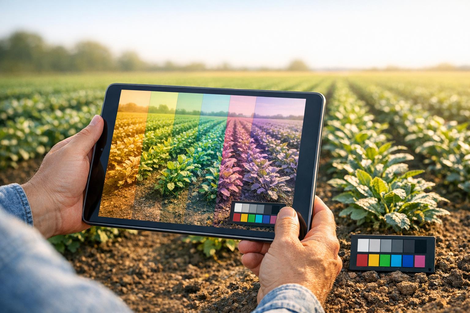
5 Key Challenges in Agricultural Spectral Imaging: Costs, Data, and Technical Barriers
Multispectral & Hyperspectral Imaging in Agriculture Webinar (previously held on April 20, 2023)
sbb-itb-ac6e058
1. High Equipment and Deployment Costs
The steep costs of equipment are a major obstacle to adopting spectral imaging technology. For instance, entry-level multispectral sensors typically cost between $3,500 and $6,000, while research-grade options from companies like AgEagle or MicaSense jump to $8,000 to $15,000. If you’re looking for hyperspectral imaging (HSI) for detailed chemical analysis, the price skyrockets - starting at $25,000 and often exceeding $100,000 for full-spectrum systems.
And that’s just the sensors. The platforms needed to deploy them add even more to the price tag. Agricultural drones, for example, range from $5,000 for models like the DJI Mavic 3 Multispectral to over $30,000 for heavy-duty or fixed-wing systems designed for longer flights. On top of that, mapping software like Pix4Dfields or DroneDeploy costs $1,500–$4,500 per year. Operational costs also pile up, including FAA Part 107 certification, insurance, regular battery replacements, and sensor calibration.
For farms opting for satellite-based imaging instead of drones, the cost structure is different but still considerable. Instead of upfront hardware costs, these farms face ongoing subscription fees. High-resolution satellite imagery typically costs around $0.80 to $6 per acre (converted from $2 to $15 per hectare). However, high minimum area requirements often make this option impractical for smaller farms.
These cumulative expenses make it difficult for smaller operations to adopt the technology.
"While the benefits of HSI are significant, challenges such as managing large volumes of data, translating spectral information into actionable insights, and ensuring cost-effective access for smallholder farmers remain barriers to its widespread adoption." - Environmental Monitoring and Assessment
The financial burden creates a clear divide. Large-scale industrial farms and specialized agricultural consultancies can absorb these costs, viewing them as long-term investments. But small and medium-sized farms often struggle to justify the expense, even though they stand to gain significantly from precision agriculture tools. For now, this technology remains largely out of reach for those who could benefit the most.
2. Large Data Volumes and Processing Requirements
Investing in spectral imaging equipment is just the beginning. The real challenge lies in managing the massive amounts of data these systems generate. To put it into perspective, a single hyperspectral image can be 50 to 100 times larger than a standard RGB satellite image. When drones are deployed across agricultural fields, the data collected can quickly add up to terabytes. This makes efficient storage and timely processing absolutely essential.
Standard storage methods simply don't cut it for hyperspectral data. These datasets need to be stored in specialized formats like Zarr or Cloud Optimized GeoTIFF (COG). These formats allow for parallel reading of spectral slices, which is critical for handling the complexity of hyperspectral data. Processing these data cubes - often containing over 200 narrow wavelength bands - requires advanced architectures such as 3D-CNNs or spectral-spatial transformers running on GPU clusters. These tools are designed to maintain the inter-band correlations that are key to identifying crop stress.
"You can't store this in folders and load it with standard image libraries."
- Ashutosh Singhal, Founder, Veriprajna
And it doesn’t stop there. Before the data can even be used, it must go through preprocessing to eliminate environmental noise. This involves using physics-based radiative transfer models to correct for atmospheric, geometric, and sub-pixel distortions caused by factors like water vapor, aerosols, and scattering. The problem? These processes take time, and delays in identifying crop stress could mean irreversible damage to the crops. On top of that, interpreting the data requires a blend of expertise in plant physiology, spectroscopy, and AI .
In short, handling hyperspectral data is a complex, resource-intensive task that demands both advanced technology and specialized knowledge. Without these, the potential of spectral imaging can’t be fully realized.
3. Environmental Interference and Signal Noise
In addition to high costs and the challenge of managing complex data, environmental factors add another layer of difficulty to using spectral imaging in agriculture. Open agricultural fields are constantly exposed to changing weather and lighting conditions, which can disrupt data accuracy. These environmental fluctuations generate signal noise, making it harder to identify the subtle spectral changes that indicate early signs of crop stress. Such variability directly impacts the ability of sensors to reliably capture the data needed for timely detection.
Passive sensors, which depend on natural sunlight, are particularly affected. Shifts in sunlight intensity and angle can distort spectral readings, leading to lower data quality. This is a significant issue for real-time crop health monitoring. Additionally, atmospheric conditions - such as humidity, water vapor, scattering, and absorption - can interfere with signal transmission in certain spectral bands. This is especially problematic when attempting to remotely measure soil moisture levels or plant water stress.
The core challenge lies in the fact that spectral imaging in agriculture occurs under "uncontrolled outdoor conditions." These factors can obscure the "invisible spectral shifts" in plant physiology that the technology is meant to detect. For instance, a nutrient deficiency or signs of water stress might exist, but atmospheric interference could block the sensor from capturing these critical signals.
This environmental interference poses a significant hurdle to the broader adoption of hyperspectral imaging in precision agriculture. Tackling these challenges is just as important as addressing cost and data management issues. To combat these problems, the industry is turning to compact active sensors that come with their own light sources, reducing reliance on sunlight and minimizing the impact of cloud cover. Furthermore, drone-based hyperspectral imaging is increasingly being paired with IoT devices and satellite data to build multi-layered monitoring systems. These systems are better equipped to account for localized environmental variations. Researchers are also advancing correction techniques designed to filter out atmospheric noise, enhancing data reliability even under variable field conditions. With these developments, new sensor technologies and integrated data strategies are helping to address the environmental challenges faced by spectral imaging.
4. Limited Spatial Resolution and Revisit Frequency
Beyond challenges like data processing and interference, another hurdle in spectral imaging for agriculture lies in balancing spatial detail with revisit frequency. These two factors - spatial resolution and how often fields are scanned - are crucial for spotting early signs of crop stress and monitoring rapid changes in plant health. Let’s break this down with some real-world examples.
Spatial resolution determines how much detail sensors can pick up. When the resolution is too low, sensors capture "mixed pixels" that combine crop and soil data. This blending makes it tough to pinpoint subtle changes in plant health or detect early signs of disease. For instance, identifying gaps in the canopy or exposed soil - key indicators for adjusting nutrition or managing pests - requires high-resolution imagery. A study at the University of Agricultural Sciences in Bangalore, India, highlights this. Using a Cubert Firefleye S 185 sensor mounted on a quadcopter flying at 20–40 meters over cabbage crops, researchers achieved an impressive 99–100% accuracy in distinguishing between crop and soil.
Revisit frequency, on the other hand, is all about timing. Monitoring dynamic processes like grain filling or senescence demands frequent scans to capture the progression of changes, not just isolated snapshots. Between 2018 and 2022, ETH Zürich’s Plant Sciences research station in Switzerland monitored 2,160 winter wheat plots. By using UAVs to scan every 2 to 7 days, the study found correlation coefficients of up to 0.9 between sensor data and visual assessments, proving that frequent revisits often matter more than sensor quality for tracking rapid crop changes.
However, there’s a trade-off between these two factors. Lower-altitude flights can capture finer details - like 3 mm resolution at 28 meters compared to 5 cm at 100 meters - but they cover less ground. Add unpredictable weather into the mix, and scan frequency takes another hit. This balancing act highlights a major limitation: without frequent, high-resolution monitoring, early signs of crop issues can go unnoticed, potentially leading to bigger problems down the line.
5. Sensor Calibration and System Integration Issues
Even after tackling cost and data concerns, ensuring sensor accuracy and smooth system integration remains a major challenge. Unlike traditional farming tools, spectral imaging systems demand ongoing calibration and expert management to deliver consistent and reliable results.
One significant hurdle is dealing with changing light conditions during UAV flights, which can disrupt multispectral accuracy. Standard calibration methods, like the Empirical Line Method, fall short when light conditions shift. Downwelling Light Sensors help improve image consistency but may compromise radiometric accuracy unless paired with reference panels captured at flight altitude. Another approach involves using multiple reference panels and calibrating each image individually, which has shown better results. These complexities make calibration a persistent issue, complicating the reliable use of these systems in real-world field conditions.
System integration adds another layer of difficulty. According to an IEEE study, while UAVs strike a balance between cost and performance, incorporating specialized payloads requires advanced engineering across optics, electronics, and aerodynamics. For agricultural applications, this means developing custom software to align sensor data with flight paths, manage battery efficiency, and automate data collection processes.
The learning curve for operators also poses challenges. Farmers need to handle large datasets, interpret complex spectral data, and integrate these findings with IoT and satellite systems. As highlighted in Environmental Monitoring and Assessment, "Collaboration among researchers, policymakers, and industry will be crucial to scaling the impact of HSI on global food systems". This collaboration is essential to share the technical workload between technology providers and agricultural users. Overcoming these calibration and integration challenges is critical for unlocking the full potential of spectral imaging in farming.
How Platforms Help Address These Challenges
Modern platforms are stepping up to tackle the challenges of high equipment costs, overwhelming data volumes, and interference from environmental factors in spectral imaging for agriculture. By integrating advanced tools and workflows, they ensure that farmers and agronomists can access consistent, actionable insights without being bogged down by technical hurdles.
One of the biggest issues is the sheer size of hyperspectral datasets. These images generate massive amounts of data, often measured in terabytes. Platforms like Anvil Labs address this by offering cloud-based hosting and processing infrastructure tailored specifically for agricultural spectral imaging. By leveraging cloud-optimized formats such as Zarr and Cloud Optimized GeoTIFF (COG), users can access specific spectral slices without needing to download entire datasets. This approach turns what could have been unwieldy data transfers into quick, focused queries that are far easier to manage.
Environmental interference and calibration challenges are another key concern, and this is where AI integration shines. Automated workflows within these platforms handle radiometric and atmospheric corrections, ensuring consistent data quality regardless of weather or lighting conditions. Ashutosh Singhal, the Founder of Veriprajna, highlights the importance of maintaining data integrity:
"When an enterprise reduces radiometric data to a visual image for the sake of using an off-the-shelf AI model, they are actively destroying data".
Platforms that prioritize preserving spectral data while applying AI-driven noise reduction ensure the diagnostic power of the technology remains intact.
Beyond processing data, these platforms also make collaboration easier. Secure sharing features allow stakeholders - farmers, agronomists, and crop insurers - to work together seamlessly. Advanced systems provide auditable workflows that trace AI-generated insights back to raw physical measurements. This transparency is especially important in agriculture, where the return on investment for spectral detection technology can exceed 150%. Instead of overwhelming field teams with raw data, platforms can deliver processed insights, such as field health alerts, enabling faster and more informed decision-making.
The real value lies in turning raw data into actionable insights. With spectral models capable of detecting crop stress 7 to 14 days before symptoms are visible, platforms that automate preprocessing, cross-calibrate data from multiple sources, and offer user-friendly tools for measurement and annotation help bridge the gap between cutting-edge technology and practical agricultural management. These solutions empower users to focus on what matters - healthy crops and better yields - without getting lost in the complexity of the technology.
Conclusion
Spectral imaging holds great promise for agriculture, but several hurdles - such as high equipment costs, large data volumes, environmental interference, limited spatial resolution, and complex calibration - still stand in the way. These challenges mean the technology is mostly limited to research labs and large-scale farming operations for now.
However, progress is happening quickly. Miniaturized hyperspectral cameras and in-sensor data compression, which can cut data volumes by 20 times, are bringing real-world applications closer to reality. Advanced calibration systems and AI-driven atmospheric corrections are also helping maintain the accuracy of spectral models, even across different soil types, climates, and weather conditions. These developments are making it easier to connect sophisticated data processing with everyday agricultural decision-making.
The Precision Agriculture Review highlights the next steps:
"Future research should prioritize the development of lightweight hyperspectral imaging systems paired with advanced computational algorithms, unified frameworks for cross-platform data fusion, and durable IoT sensors tailored for harsh field conditions".
The market for hyperspectral imaging in agriculture is expected to surpass $400 million globally by 2025, with more than 60% of precision agriculture systems likely to incorporate this technology for crop monitoring.
The real challenge now is transitioning spectral imaging from a research tool to an everyday farming solution. The goal is to turn complex spectral data into actionable insights - like identifying nutrient deficiencies, spotting early signs of disease, and fine-tuning irrigation plans - that farmers can use right away.
As advancements in hardware and software continue to align, spectral imaging is poised to become a key part of sustainable crop management. Whether it becomes a mainstream tool or remains a niche technology will depend on the development of standardized protocols, durable field sensors, and affordable deployment options.
FAQs
Is multispectral imaging enough, or do I need hyperspectral?
Multispectral imaging is a reliable option for various agricultural tasks, such as spotting stress or monitoring diseases. It works by capturing data from a limited number of spectral bands. On the other hand, hyperspectral imaging dives much deeper, analyzing hundreds of spectral bands. This allows it to detect finer details, like early signs of nutrient deficiencies or disease symptoms that might otherwise go unnoticed.
While hyperspectral imaging provides more detailed insights, it comes with higher costs and added complexity. Deciding between the two depends on your budget, specific needs, and how much precision your application demands.
What’s the simplest way to store and process hyperspectral data?
The easiest approach to manage and process hyperspectral data is by using platforms specifically built for handling large datasets. These platforms are equipped with features like real-time processing, data compression, and secure management, which streamline hyperspectral imaging workflows and ensure efficient data handling.
How can I reduce noise from sunlight and weather in field scans?
To reduce interference from sunlight and weather, aim to conduct scans under steady lighting conditions, like at solar noon or when it's overcast. For precise calibration, use reflectance panels both before and after your flights. Attach sunlight sensors to drones to monitor light variations and make necessary processing adjustments. Also, plan scans during calm weather, steering clear of high winds or rain to ensure the quality of your data remains intact.
