Photogrammetry transforms aerial images into precise 3D models and maps by correcting distortions and aligning data to real-world coordinates. Accuracy is key for applications like construction, inspections, and environmental monitoring, ensuring reliable data for decision-making and compliance. Here's what you need to know:
-
Accuracy Types:
- Relative Accuracy: Ensures internal consistency within the model.
- Absolute Accuracy: Aligns the model with global geographic coordinates.
-
Key Metrics:
- RMSE (Root Mean Square Error): Measures error distribution; lower values indicate better accuracy.
- Reprojection Error: Evaluates image alignment; below 0.5 pixels is ideal.
- Standards: The ASPRS 2024 update uses RMSE as the main accuracy metric, setting clear benchmarks for horizontal and vertical precision.
- Improving Accuracy: Factors like flight planning, image overlap, GCPs, and RTK/PPK systems are critical.
Photogrammetry Accuracy Metrics
Relative vs. Absolute Accuracy
To evaluate photogrammetry data effectively, it's important to distinguish between relative accuracy and absolute accuracy. Relative accuracy focuses on the internal consistency of a model - essentially, whether the measurements and dimensions within the dataset match the real-world values. For instance, if a wall is 10 feet long in reality, does the model reflect that same measurement? This ensures the model's geometry is correct within itself.
Absolute accuracy, however, goes a step further by assessing how well the model aligns with global geographic coordinates, such as WGS84 or UTM. It answers the question: where, geographically, is a feature located? A model might have excellent relative accuracy but still fall short in absolute accuracy if it hasn't been properly georeferenced to a global coordinate system. Ian Jack from Alpine Reality Capture explains this distinction clearly:
Relative and absolute accuracy are independent characteristics. A scan can have excellent relative accuracy but poor absolute accuracy if georeferencing is performed incorrectly.
The total point error combines both internal and georeferencing errors. Depending on the project, the importance of each type of accuracy varies. For tasks like volumetric calculations or as-built documentation, relative accuracy might suffice. However, projects requiring GIS integration, regulatory compliance, or change monitoring demand high absolute accuracy. Achieving this often involves RTK, PPK, or well-distributed Ground Control Points (GCPs).
These concepts become even clearer when paired with statistical accuracy metrics, which are explored in the next section.
RMSE and Reprojection Error Metrics
Building on the understanding of accuracy, Root Mean Square Error (RMSE) is a key metric used to measure error distribution within a model. Expressed in the same units as the dataset (e.g., inches or feet), RMSE reflects the standard deviation of errors across the data. For example, if a model specifies an RMSE of 3 cm, it means that 68% of the errors fall within 3 cm, 95% within 6 cm, and 99.7% within 9 cm.
There are two types of RMSE to consider:
- GCP RMSE: This measures how well the model fits the Ground Control Points.
- Checkpoint RMSE: This measures real-world accuracy using independent survey points.
As Eric from RangePointGeo explains:
Checkpoint RMSE... is the only number that reflects real-world accuracy.
A low RMSE indicates that the model translates photogrammetric measurements into real-world applications reliably.
The reprojection error acts as an internal quality check, assessing how well the bundle adjustment model aligns overlapping images. A median reprojection error below 1 pixel is standard, with values below 0.5 pixels considered good, and below 0.3 pixels being excellent. For high-quality surveys, a Checkpoint RMSE target of 1–2× the Ground Sample Distance (GSD) is typical. It's worth noting that vertical accuracy in nadir-only flights is generally 2–3 times less precise than horizontal accuracy.
sbb-itb-ac6e058
Industry Standards and Benchmarks
ASPRS Positional Accuracy Standards

The American Society for Photogrammetry and Remote Sensing (ASPRS) has established the Positional Accuracy Standards for Digital Geospatial Data, which serve as a key reference across the industry. The most recent version, Edition 2, Version 2, was finalized in June 2024. This update was the result of collaboration among 40 experts from public, private, and academic sectors. It replaces the 1947 NMAS framework with a modern, sensor-agnostic, and data-driven approach. The new standards rely solely on Root Mean Square Error (RMSE) as the primary accuracy metric, moving away from the previously used 95% confidence level, which often caused confusion.
Dr. Qassim Abdullah, Vice President and Chief Scientist at Woolpert, highlighted the importance of this update:
"The publication of this new edition of the accuracy standards came in response to evolving technologies and industry needs. It will have a positive and lasting impact on geospatial capabilities... worldwide."
The revised standards introduce a new method for assessing 3D accuracy, using the formula RMSE₃D = √(RMSEₓ² + RMSEᵧ² + RMSE_z²). Additionally, the accuracy requirements for ground control points have been adjusted. Instead of the earlier 3× or 4× safety factor, ground control points now need to be twice as accurate as the final target accuracy. This change allows RTK-based surveys to qualify for high-accuracy products that were previously out of reach.
Checkpoint requirements have also been updated. For projects under 1,000 square kilometers, the minimum number of checkpoints has increased from 20 to 30. For larger projects exceeding 10,000 square kilometers, the maximum is capped at 120 to avoid excessive costs in remote areas. The 2024 standards include detailed addenda covering Lidar, Photogrammetry, UAS, Oblique Imagery, Field Surveying, and General Best Practices.
How Standards Are Used in Practice
The updated standards ensure accuracy throughout the entire production process by defining clear benchmarks for each step. Users can specify the desired final product accuracy, while the standards automatically outline the requirements for intermediate steps like aerial triangulation, ground control point accuracy, and checkpoint accuracy. For instance, aerial triangulation accuracy for 3D products must be 0.5× the target RMSE, while digital orthoimagery requires seamline mismatches to remain at or below 2× RMSEₕ.
When validating vertical accuracy in areas with vegetation, the standards now distinguish between Non-Vegetated Vertical Accuracy (NVA) and Vegetated Vertical Accuracy (VVA). Projects are assessed based on NVA, while VVA is recorded separately and does not impact acceptance.
Another critical update involves factoring checkpoint accuracy into the final product's accuracy. This is especially important for high-accuracy products, where even small checkpoint errors can significantly affect results. For drone lidar projects, horizontal accuracy can be calculated using the ASPRS formula, which incorporates GNSS positional accuracy, IMU parameters (roll, pitch, heading), and flying height.
Factors That Affect Photogrammetry Accuracy
Flight Planning and Image Capture
The accuracy of photogrammetry starts with Ground Sampling Distance (GSD). This metric measures the distance between the centers of two adjacent pixels on the ground, directly impacting the detail captured. Typically, horizontal accuracy is 1 to 2 times the GSD, while vertical accuracy is 2 to 3 times the GSD. For instance, with a 1-inch GSD, you can expect horizontal accuracy to fall between 1–2 inches and vertical accuracy between 2–3 inches.
Image overlap plays a major role in ensuring accurate reconstructions. For most projects, aim for at least 75% frontal overlap and 60% side overlap. However, in tricky environments like forests or snowy areas, increase overlap to at least 85% frontal and 70–85% side. Urban settings with tall structures may require 85% frontal and 70% side overlap, coupled with a double grid flight path and a camera tilt between 10° and 35° to capture building facades effectively. These adjustments help mitigate environmental challenges that could otherwise compromise the survey.
Environmental conditions can also impact results. Bright sunlight often causes harsh shadows and reflections, obscuring details, while wind can lead to motion blur. Uniform surfaces such as snow, sand, or water make it harder for photogrammetry software to identify keypoints. For water-heavy areas, ensure that at least three-quarters of the image includes recognizable land features to aid reconstruction.
Camera settings are another critical factor. For best results, set your camera focus to infinity, turn off internal stabilization, and use a fixed focal length throughout the flight. If you're flying a DJI drone, disable the "Dewarping" feature to ensure the software can accurately interpret internal camera geometry (like focal length and distortion) and external parameters (such as image position and orientation).
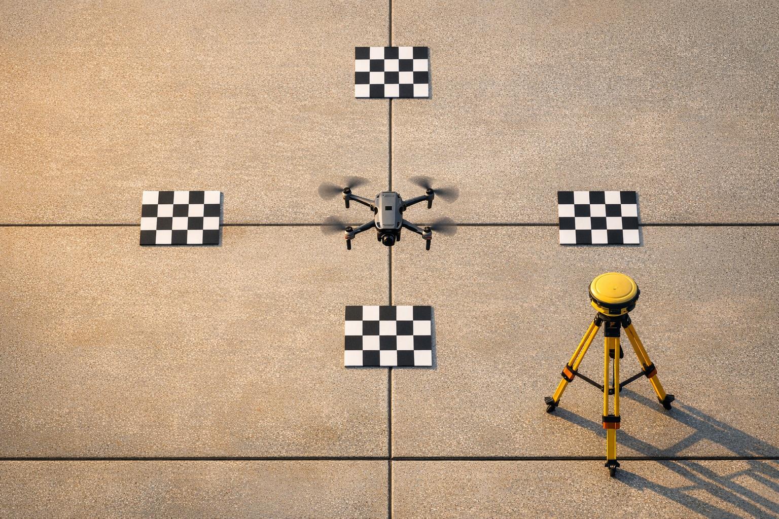
Ground Control Points and RTK/PPK
Once you've optimized your flight plan and image capture, precise georeferencing becomes the next focus. This is where Ground Control Points (GCPs) and RTK/PPK workflows come into play.
GCPs are still a go-to method for improving and validating absolute accuracy, even when using advanced RTK or PPK systems. Proper placement of GCPs is key - distribute them evenly across the project area, ensuring each target is 5–10 times the GSD in size. Additionally, offset them slightly from the project edges to enhance coverage.
RTK (Real-Time Kinematic) and PPK (Post-Processed Kinematic) systems provide centimeter-level positioning accuracy, significantly boosting the precision of georeferencing. While a drone’s onboard GPS can handle basic georeferencing, RTK/PPK workflows reduce the need for numerous GCPs. Even so, checkpoints remain essential to confirm that the final outputs meet the required accuracy standards.
What Industry Accuracy Standards Apply to Drone-Captured Mapping Products? (YDQA Ep 96)
How to Achieve and Validate Accuracy Standards

ASPRS Photogrammetry Accuracy Classes: RMSE Standards and 95% Confidence Levels
To meet photogrammetry accuracy standards, it's essential to follow specific steps based on established industry guidelines. Here's how you can ensure and validate accuracy in your projects.
Steps for Meeting Standards
Achieving accuracy standards, such as those set by ASPRS, involves using RMSE-based metrics rather than traditional map scales. Start by calibrating your camera sensors and lenses to determine precise interior orientation parameters, including focal length, principal point, and radial distortion. Proper calibration before data capture helps prevent errors from affecting the entire workflow.
Once you've completed the bundle block adjustment, carefully examine σ₀ (sigma naught) and residuals to identify and remove any outliers before finalizing your outputs. Validation hinges on using Independent Check Points (ICPs) - surveyed ground points that are distributed across your project area but excluded from the initial data processing or bundle adjustment. This ensures an unbiased validation process.
For effective statistical validation, use at least 20 ICPs. The accuracy of these check points must be at least three times better than the target accuracy of your photogrammetric product. For example, if your goal is a 5 cm accuracy class, the check points should be surveyed to within 1.7 cm or better.
Once your outputs are validated, compare the results against ASPRS accuracy classes as outlined below.
Comparing Accuracy Classes with Tables
ASPRS defines accuracy classes based on the maximum allowable RMSE (in cm) for horizontal (RMSE_x and RMSE_y) and vertical (RMSE_z) measurements. To report accuracy at a 95% confidence level, multiply your RMSE_r (radial RMSE) by 1.7308 for horizontal measurements and RMSE_z by 1.9600 for vertical measurements.
The table below illustrates the accuracy classes and their corresponding 95% confidence levels:
| ASPRS Accuracy Class | RMSE_x and RMSE_y (cm) | RMSE_z (cm) | Horizontal Accuracy at 95% Confidence (cm) | Vertical Accuracy at 95% Confidence (cm) |
|---|---|---|---|---|
| 5 cm | ≤ 5.0 | ≤ 5.0 | 12.2 | 9.8 |
| 10 cm | ≤ 10.0 | ≤ 10.0 | 24.5 | 19.6 |
| 15 cm | ≤ 15.0 | ≤ 15.0 | 36.7 | 29.4 |
| 20 cm | ≤ 20.0 | ≤ 20.0 | 49.0 | 39.2 |
| 50 cm | ≤ 50.0 | ≤ 50.0 | 122.4 | 98.0 |
For example, the 5 cm accuracy class allows for an RMSE of up to 5.0 cm in both horizontal and vertical measurements. When reported at the 95% confidence level, this translates to a horizontal accuracy of 12.2 cm and a vertical accuracy of 9.8 cm. While workflows using RTK/PPK can reduce the number of ground control points (GCPs) required, independent check points remain critical for proper validation and compliance.
Anvil Labs: Tools for Accuracy Validation

Once your data meets ASPRS standards, having a dedicated platform for ongoing validation and efficient data management becomes essential. Anvil Labs offers such a solution, providing tools to manage spatial data and ensure accuracy metrics are consistently validated. The platform allows you to host, analyze, and share your results seamlessly.
Data Hosting and Processing
Anvil Labs aligns with ASPRS guidelines to ensure that all measurements and adjustments adhere to industry standards. The platform supports a wide range of photogrammetry data types, including 3D models, orthomosaics, LiDAR point clouds, 360° photos, and thermal imagery. This versatility allows for precise cross-verification of spatial measurements. For instance, you can compare elevation models derived from photogrammetry with LiDAR data to confirm vertical accuracy, while orthomosaics can be used to validate horizontal positioning. By centralizing asset hosting, the platform maintains data integrity throughout the validation process, minimizing the risk of errors that can occur when transferring data manually between systems.
Measurement and Validation Tools
The platform’s built-in measurement tools allow for direct analysis and comparison of spatial data. Features like side-by-side comparison views, elevation color-mapping, and measurement overlays can be customized to emphasize the accuracy metrics most relevant to your needs. These tools also help ensure compliance with specific ASPRS accuracy classes. Furthermore, the platform integrates seamlessly with external data systems, enhancing the overall accuracy management process.
Integrations for Better Accuracy
Anvil Labs connects with RTK/PPK data processing systems, enabling the import of highly precise drone data to refine photogrammetry results. It also integrates with AI analysis tools that automatically compare 3D models against reference datasets, identifying areas where accuracy may have degraded or where systematic errors, such as lens distortion, might be present. Additionally, task management integrations streamline workflows by converting findings into actionable tasks - like re-processing specific sections or collecting more ground control points in areas with lower accuracy. These integrations cover the entire workflow, from data hosting to real-time validation, ensuring your photogrammetry outputs consistently meet high accuracy standards.
Conclusion
Photogrammetry accuracy standards play a key role in ensuring dependable drone surveys, helping to avoid costly mistakes and solidifying client confidence. By adhering to ASPRS positional accuracy standards, you can align your projects with industry benchmarks and regulatory guidelines.
The path to achieving this precision lies in practical implementation. It starts with meticulous flight planning - ensuring optimal overlap and altitude - and extends to the strategic use of ground control points (GCPs). Incorporating RTK/PPK technology can significantly reduce the need for GCPs by 70–90%, as noted in industry studies. These elements directly impact whether your data meets ASPRS Class 1 accuracy (RMSE XY ≤ 1.0 ft) or misses the mark.
Validation bridges the gap between theory and execution. By running quality checks, comparing results to accuracy class tables, and refining processes as needed, you can turn raw drone data into certified geospatial assets. Tools like Anvil Labs simplify this process by hosting orthomosaics and LiDAR point clouds, offering measurement tools to confirm RMSE thresholds in imperial units, and integrating AI-driven analysis for automated validation.
As drone technology progresses toward sub-inch accuracy and AI-powered workflows become the norm, the tools and standards you adopt today will prepare you to surpass future expectations. Embracing these standards and leveraging platforms like Anvil Labs ensures your photogrammetry projects meet the high precision requirements of industrial, construction, and mapping applications.
FAQs
When do I need absolute accuracy vs relative accuracy?
Absolute accuracy is crucial when tasks require precise alignment with real-world coordinates. This is often the case in fields like legal work or engineering, where even minor discrepancies can lead to significant issues. On the other hand, relative accuracy is sufficient for applications like visual inspections or comparing features within a single dataset. The choice between the two depends entirely on how precise your project needs to be.
How many checkpoints do I need to prove accuracy?
Using 5 to 10 Ground Control Points (GCPs) is generally advised for achieving accurate results in drone surveying. Placing these points strategically across the survey site - especially in areas with varying elevations - helps enhance both precision and the quality of georeferencing.
How do I pick the right GSD for my accuracy goal?
To determine the right Ground Sampling Distance (GSD) for your accuracy needs, think about the level of detail your project requires and how GSD impacts precision. A smaller GSD, like 1 cm/pixel, provides higher resolution, making it perfect for tasks that demand fine detail, such as inspections. Achieving lower GSDs often means flying at lower altitudes and using high-resolution cameras. To ensure your images meet your accuracy standards, use a GSD calculator or input details like camera specifications, flight altitude, and image dimensions.
