
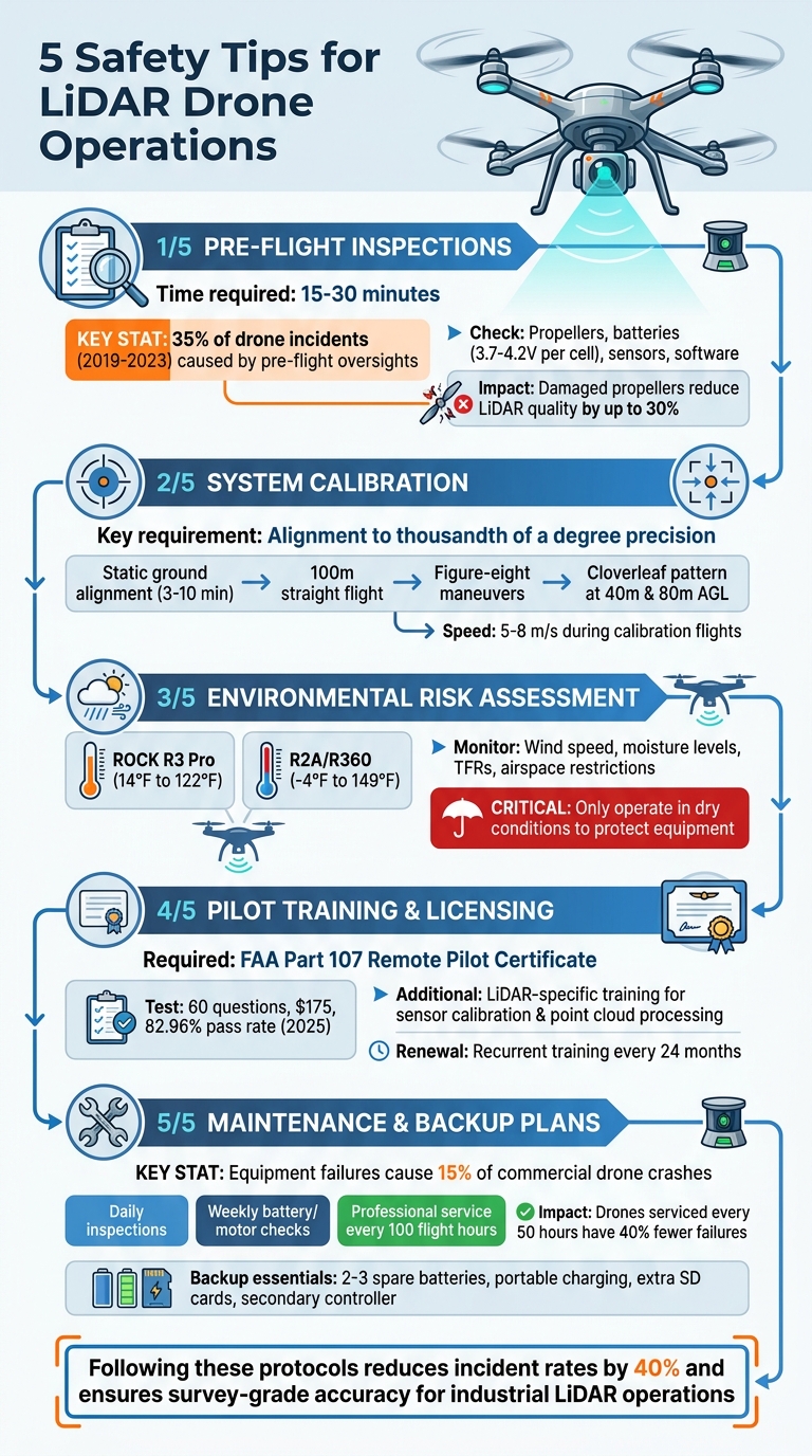
Operating LiDAR drones requires precision and careful planning to avoid accidents, protect equipment, and ensure accurate data collection. Here’s a quick look at five key tips to enhance safety and data reliability:
- Pre-Flight Inspections: Check propellers, batteries, sensors, and software to prevent equipment failures and ensure smooth flights.
- System Calibration: Align LiDAR and IMU systems to maintain data accuracy during operations.
- Environmental Risk Assessment: Monitor weather, airspace, and site conditions to avoid issues like wind interference or moisture damage.
- Pilot Training: Ensure operators have FAA Part 107 certification and specialized LiDAR training for handling complex tasks.
- Maintenance and Backup Plans: Regularly service equipment, carry spares, and establish contingency plans to minimize downtime.
These steps help reduce risks, improve efficiency, and ensure high-quality LiDAR data for industrial applications. Proper preparation and adherence to safety protocols are essential for successful drone operations.
5 Essential Safety Steps for LiDAR Drone Operations
Drone LiDAR Requirements in Utilities (8 Best Practices)
sbb-itb-ac6e058
1. Complete Pre-Flight Inspections
Thorough pre-flight inspections are a must for ensuring both flight safety and reliable data collection. These checks typically take 15–30 minutes but are critical, especially for LiDAR operations where precision is everything. According to FAA data, 35% of drone incidents between 2019 and 2023 were caused by pre-flight oversights, such as neglected battery checks or damaged propellers.
Start with the propellers. Remove each one and inspect for cracks, chips, or imbalances by spinning them manually. If you find nicks deeper than 1 mm, replace the blade immediately - damaged propellers can create vibrations that reduce LiDAR point cloud quality by up to 30%. Next, check the drone's frame and motors. Look for cracks at stress points like the arms or body seams, and ensure motor bearings are in good condition. Worn bearings can increase the risk of failure by 50% during flights with heavy payloads.
Battery health is another critical factor. Use a multimeter to measure the voltage of individual cells, ensuring each reads between 3.7–4.2 V. The total pack voltage should align with the manufacturer's specifications (e.g., 22.2 V for a 6S LiPo battery), and the capacity should be at least 80% of its rated health. Low battery performance is responsible for 25% of emergency landings, and with LiDAR missions lasting 20–40 minutes, dependable power is non-negotiable.
Next, focus on the LiDAR sensor. Clean its lenses using a microfiber cloth and isopropyl alcohol, and check that the mounting screws are tightened to 2–3 Nm. Even minor dust or debris on the sensor windows can reduce scan accuracy by 25%, resulting in noisy point clouds that may compromise the accuracy of platforms like Anvil Labs, which depend on precise 3D modeling. Inspect all cable connections by disconnecting and reconnecting them, looking for issues like frayed insulation, bent pins, or corrosion. Loose connections have been linked to 15% of sensor failures during field operations.
Finally, verify that all software and firmware are up to date. Update the flight controller, LiDAR SDK, and companion computer operating system to their latest stable versions. Run a pre-arm checklist to confirm GPS lock, compass calibration, and proper LiDAR streaming. Skipping these steps can lead to 10–20% data dropouts. A 2022 DJI enterprise survey highlighted this importance: operators who conducted full inspections reported flight interruptions only 8% of the time, compared to 62% for those who skipped these checks.
2. Calibrate LiDAR and Drone Systems
Once the pre-flight inspections are complete, the next step is calibration. This process is essential to ensure that LiDAR data is precise. It involves aligning the LiDAR scanner with the Inertial Measurement Unit (IMU) to correct for roll, pitch, and heading misalignments. As Phoenix LiDAR Systems explains, "The scanner's orientation in respect to the center of navigation (usually the IMU) must be known to the thousandth of a degree if range measurements are to be made over long distances". Such precision is crucial for creating accurate 3D models on platforms like Anvil Labs.
Begin with a static ground alignment by placing the system on a flat surface for 3–10 minutes. After takeoff, fly straight for 100 meters at a speed of 5 m/s, then perform three figure-eight maneuvers to stabilize the IMU's orientation.
Follow this with a cloverleaf flight pattern, flying two sets of perpendicular lines over hard surfaces. Conduct these flights at altitudes of 40 meters and 80 meters Above Ground Level (AGL), maintaining a speed of 6–8 m/s. Space the lines about 65 feet apart to ensure proper overlap.
To capture precise positioning, configure the GNSS reference station to record raw observations at 1 Hz, using multiple constellations (GPS, GLONASS, Galileo, Beidou) and frequencies (L1, L2, L5). After completing the calibration pattern, repeat the figure-eight and straight-line flights, then finish with a final static alignment. If you’re using a camera to colorize the point cloud, double-check the lens focus before starting.
3. Assess Environmental Risks
Before taking off, it’s crucial to evaluate weather and airspace conditions to protect your equipment and ensure accurate data collection. This step goes hand-in-hand with the pre-flight inspections and calibrations mentioned earlier.
Temperature is a key factor to consider. The ROCK R3 Pro and R3 Pro V2 operate safely between 14°F and 122°F, while the ROCK R2A and ROCK R360 can handle a broader range of -4°F to 149°F. Operating outside these limits can lead to data errors and equipment issues. Extreme cold drains batteries faster, while high heat can lead to power failures mid-flight. To avoid these problems, make sure to pre-condition your batteries accordingly.
Wind conditions also play a big role in data quality. It’s important to measure wind speeds at your intended flight altitude. As Measure Australia explains:
"Our operations team and pilots regularly monitor the weather to ensure the environmental conditions are adequate for flying and therefore, safety is assured to all those involved and the quality of data is not affected".
Always respect your drone's wind tolerance. Turbulent conditions can force the drone to make constant adjustments, which can result in noisy data due to shifts in the IMU and LiDAR orientation.
Moisture poses another significant risk. Most LiDAR systems aren’t designed to operate in wet conditions. Flying in fog, mist, or rain can physically damage the equipment. Snow brings its own challenges, as LiDAR may capture the snow's surface instead of the actual ground, leading to inaccurate topographic data. To ensure precise results, only operate in dry conditions.
Lastly, check for Temporary Flight Restrictions (TFRs) and controlled airspace using mapping software before every flight. With LiDAR systems costing anywhere from tens of thousands to hundreds of thousands of dollars, thorough pre-flight planning is non-negotiable. Staying informed through professional drone networks and regulatory updates helps you avoid compliance issues and ensures a smooth operation. Combined with pre-flight checks and calibration protocols, these measures are critical for managing risks effectively.
4. Verify Pilot Training and Licensing
If you're operating LiDAR-equipped drones, proper certification isn't just a formality - it's a legal requirement. In the United States, every commercial drone operator must hold an FAA Remote Pilot Certificate (Part 107). This certification involves passing the Unmanned Aircraft General - Small (UAG) Knowledge Test, a 60-question exam that costs $175 and had a pass rate of 82.96% in 2025. As Sally French, also known as The Drone Girl, explains:
"Having your Remote Pilot Certificate opens you up to legal commercial drone work... and it signals to clients that you take the work seriously".
This certification ensures pilots are equipped to handle the unique demands of LiDAR operations. However, the basics aren't enough when it comes to this specialized technology. Pilots also need LiDAR-specific training to address challenges like sensor calibration, point cloud processing, and SLAM (Simultaneous Localization and Mapping). While the FAA doesn’t require this additional training, programs from institutions like ROCK Academy and Candrone Academy teach these critical skills, which are essential for achieving survey-grade accuracy and avoiding costly mistakes.
On top of certification, all commercial drones must be registered with the FAA, which costs $5 for three years. As of September 16, 2023, drones are also required to broadcast Remote ID information unless operating in an FAA-Recognized Identification Area. To keep your certification active, pilots must complete a free online recurrent training course every 24 months. Missing these deadlines could halt operations and lead to regulatory fines.
Before deployment, make sure pilots meet all eligibility criteria: they must be at least 16 years old, proficient in English, and physically and mentally capable of flying safely. Additionally, set up an IACRA profile to obtain an FAA Tracking Number before scheduling the knowledge test. Keeping detailed equipment logs for LiDAR calibration is also crucial to ensure compliance if you're audited. Verifying pilot training and licensing is a key step in maintaining the safety and reliability of your operations.
5. Maintain Equipment and Prepare Backup Plans
After pre-flight protocols, the next step to ensure mission success is consistent maintenance and having backup plans ready. According to the FAA's 2023 report, equipment failures account for 15% of commercial drone crashes, with 28% of those linked to battery issues. Regular maintenance is the key to avoiding costly disruptions. Here’s a simple maintenance schedule to follow:
- Daily: Inspect for visible damage, clean critical components, and confirm firmware updates.
- Weekly: Check battery health, inspect motors, and recalibrate GPS.
- Every 100 flight hours or six months: Arrange professional servicing in line with FAA Part 107 guidelines.
A 2024 study by DJI showed drones serviced every 50 flight hours experienced 40% fewer failures compared to those without scheduled maintenance.
Specialized equipment like LiDAR sensors requires extra attention. Vibrations can misalign their rotating mirrors and fiber optics, resulting in inaccurate point clouds. To maintain precision (within 1–2 cm), calibrate sensors every 50 flight hours using tools like DJI Terra. In challenging environments - like dusty Midwest farms or humid coastal areas - clean the sensors more often, ideally every two weeks. If operating near saltwater, rinse the equipment with freshwater after each flight. Additionally, protect batteries by insulating them during extreme temperatures below 32°F or above 104°F.
Always carry essential backups. Pack 2–3 fully charged spare batteries (each offering about 30 minutes of flight time, such as DJI Matrice 300 batteries at 5,840 mAh), a portable charging station with solar support, an extra 128GB UHS-I SD card, and a secondary controller. For example, during a 2023 construction site survey, a DJI Zenmuse L1 LiDAR failed mid-flight due to dust buildup. Thanks to weekly cleaning and backup equipment, the team quickly swapped out the sensor, avoiding an estimated $10,000 in downtime.
Having a response plan for common risks is equally important. Set auto-return-to-home triggers when battery levels hit 20%, pre-map secondary landing zones, and establish manual override protocols. Apps like Litchi can automate alternative flight paths, while radio backups ensure team communication during emergencies. Conducting simulation drills has been shown to reduce incident rates by 40%, according to NTSB reports. Post-flight, analyze telemetry data for issues like battery voltage drops or GPS drift. Tools like Pix4D can verify data quality, helping predict potential failures, extend equipment lifespan by 30%, and keep records compliant with FAA regulations.
Conclusion
Operating LiDAR drones safely requires a disciplined approach that not only protects your equipment but also ensures the collection of precise, professional-grade data. Key practices like pre-flight inspections, system calibration, environmental risk assessments, pilot certification, and regular equipment maintenance work together to create a comprehensive safety framework. Ignoring even one of these steps can lead to costly failures and project delays.
These measures do more than just prevent accidents - they also improve efficiency. Following safety protocols consistently reduces downtime, lowers insurance expenses, and boosts data quality. For industries managing complex sites, this dependability is crucial. High-quality LiDAR data, gathered under strict safety guidelines, supports better asset management and enables secure data sharing across teams.
"By investing in proper planning and preparation, adhering to safety guidelines, and implementing effective data collection and analysis techniques, businesses can maximize the benefits of drone inspections and generate valuable insights to support decision-making and asset management." - Anvil Labs
The quality of your LiDAR data is a direct reflection of how rigorously you follow safety protocols. Accurate calibration results in precise data. Well-maintained equipment minimizes the risk of mid-flight failures. Skilled pilots can adjust flight settings on the spot to maintain data integrity. Platforms like Anvil Labs make it easy to upload and manage this data, offering features like cross-device accessibility, annotation tools, thermal imagery integration, and long-term asset tracking.
A strong commitment to safety not only protects your technology investment but also ensures that every flight produces reliable, actionable results. Monitor key metrics like incident rates, calibration accuracy, and data quality to evaluate your program's effectiveness. Regular training, well-documented procedures, and a focus on continuous improvement will keep your operations aligned with FAA regulations and industry standards, delivering the precise spatial data needed for effective industrial site management.
FAQs
What’s the fastest pre-flight checklist for a LiDAR mission?
To keep your LiDAR mission on track and efficient, focus on the essentials during pre-flight checks. Start by visually inspecting the site for any obstacles and confirming that the weather conditions are suitable - think clear skies and minimal wind. These factors are crucial for both safety and data accuracy.
Next, verify that all equipment is properly calibrated, sensors are securely mounted, and the GNSS signal is strong enough for reliable positioning. Double-check your flight plans, confirm flight parameters like altitude and coverage area, and ensure batteries are fully charged.
By staying sharp and methodical with these steps, you’ll avoid unnecessary delays while ensuring both safety and high-quality data collection.
How can I tell if my LiDAR/IMU calibration is off?
To spot calibration problems, compare your data's accuracy against reference data and Ground Control Points (GCPs). Pay attention to any misalignments or inconsistencies in your 3D models. It's also important to confirm that your sensors are correctly calibrated. If calibration is off, you might experience positional drift or distorted imagery. Regular checks are key to ensuring your data remains reliable and accurate.
What weather conditions most often ruin LiDAR data?
LiDAR data accuracy can be impacted by rain, fog, drizzle, and high winds during drone operations. These weather conditions can disrupt the data collection process, so it's best to avoid them to ensure reliable results.
