Digital twins and LiDAR are reshaping tunnel surveys by replacing outdated, risky, and time-consuming methods with precise, remote solutions. Here's how they work:
- Digital twins are virtual replicas of tunnels, updated in real time with data from sensors and LiDAR. They allow engineers to monitor conditions, predict maintenance needs, and simulate scenarios like flooding or structural failures.
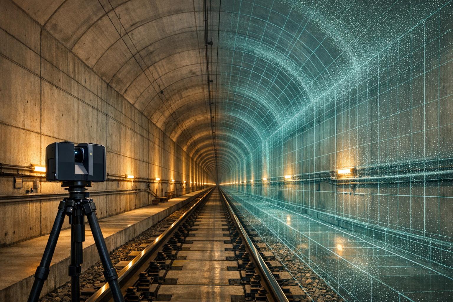
- LiDAR scanning uses laser pulses to create accurate 3D maps of tunnel interiors, even in dark or hard-to-reach areas. It speeds up data collection by up to 60% and achieves precision within inches.
- Combining digital twins with LiDAR improves safety, reduces costs, and extends the lifespan of tunnel infrastructure. For example, the Neuglobsow Tunnel project in Germany saved $1.2 million and predicted risks months in advance using these technologies.
These tools cut inspection times, minimize risks to workers, and streamline maintenance by providing a single source of reliable data. With growing adoption, they are setting a new standard for managing tunnels efficiently and safely.

Digital Twins and LiDAR Benefits for Tunnel Infrastructure: Key Statistics
What Are Digital Twins for Tunnel Infrastructure?
Digital Twin Definition and Core Functions
A digital twin is essentially a dynamic digital replica of a physical tunnel. It captures and mirrors the tunnel's geometry, condition, and performance in real time by continuously updating with data from sources like sensors, LiDAR, and IoT devices.
Key functions include:
- Real-time monitoring: Tracks the structural integrity of the tunnel, identifying issues as they arise.
- Predictive maintenance: Anticipates potential problems, such as cracks or water ingress, before they escalate into emergencies.
- Scenario simulation: Models events like ventilation system failures or flooding to prepare for and mitigate risks.
These digital models often integrate with BIM systems, supporting the tunnel's lifecycle from design and construction to eventual decommissioning.
For example, in 2022, Hochtief AG created a digital twin for the Neuglobsow Tunnel in Germany. Using drone LiDAR and IoT sensors, they scanned a 1.6-mile stretch in just 48 hours with an impressive 0.08-inch accuracy. This effort slashed inspection costs by 40%, saving $1.2 million, and helped predict water ingress risks three months in advance, averting potential collapse. This case illustrates how precise data collection and simulation capabilities enhance tunnel safety and maintenance efficiency.
These core functions lay the groundwork for solving the unique challenges of tunnel environments.
How Tunnel Infrastructure Uses Digital Twins
Digital twins are specifically designed to tackle the unique challenges that come with managing tunnel infrastructure.
Underground tunnels present several obstacles. Limited access makes regular inspections costly and time-consuming. Workers face safety risks from hazardous gases, potential collapses, and poor visibility. Additionally, complex geometries, like curved walls and irregular surfaces, make traditional mapping methods unreliable, especially for older tunnels.
Digital twins address these issues head-on. They offer immersive 3D visualizations that allow engineers to perform inspections remotely, cutting the need for on-site personnel by 70% and reducing exposure to dangerous conditions. Advanced meshing techniques, powered by multi-angle LiDAR scans, accurately capture the intricate curves and surface details of tunnels. Meanwhile, real-time data from embedded sensors - such as strain gauges and humidity monitors - feeds directly into the digital twin. This enables alerts when vibration patterns or other indicators suggest structural problems.
sbb-itb-ac6e058
Underground Tunnel Scanning with XGRIDS Lixel L2 Pro – Fast, Accurate, True Color
LiDAR Scanning for Tunnel Data Capture
LiDAR (Light Detection and Ranging) technology uses laser pulses to measure distances, creating highly detailed 3D maps of tunnel interiors. By emitting rapid laser pulses that reflect off tunnel surfaces, LiDAR generates precise point clouds, capturing features with accuracy down to a few centimeters. This makes it an ideal choice for tunnel environments where traditional surveying methods face challenges. LiDAR maintains sub-10 cm accuracy even in complete darkness, through dust, or in tight spaces where GPS signals can't reach. Advanced systems can achieve precision between 0.8 and 2 inches while cutting data collection times by as much as 60% compared to conventional methods. This detailed data is critical for building digital twins used in tunnel maintenance.
Modern LiDAR systems often combine photogrammetry with laser scanning, integrating visual imagery with spatial data to create highly accurate digital elevation models (DEM) and digital surface models (DSM). These models provide both precise measurements and visual context. When paired with AI-powered tools, LiDAR systems can automatically detect structural issues, such as cracks or geological features, that might be missed during manual inspections.
3 Types of LiDAR Scanning for Tunnels
Terrestrial LiDAR scanning uses stationary, tripod-mounted scanners set up at multiple locations within the tunnel. These scanners capture overlapping scans to cover the entire tunnel cross-section with exceptional precision - often within 0.8 inches. This method is perfect for detailed structural assessments and as-built documentation, though it does require careful positioning and calibration.
Mobile LiDAR scanning mounts scanners on vehicles or backpack systems, significantly speeding up survey times while maintaining accuracy between 1.2 and 2 inches. As the platform moves through the tunnel, it collects data in a single pass. This approach is especially useful for long tunnels where setting up stationary scanners would be inefficient, allowing coverage of thousands of feet in just hours.
Aerial LiDAR scanning employs drone-mounted sensors to survey tunnel portals, ventilation shafts, and nearby areas. While drones can't navigate deep within tunnels, they excel at capturing data around access points and external structures. Multirotor drones handle precise, localized mapping near tunnel entrances, while fixed-wing drones are better for surveying long-range areas like tunnel approaches and surrounding terrain.
Benefits of Combining LiDAR Methods
Using a combination of these LiDAR methods creates a robust dataset that balances detailed precision with broader contextual insights. For example, terrestrial scanning can focus on critical structural zones requiring maximum accuracy, mobile scanning can efficiently cover the tunnel's length, and aerial LiDAR can map portal areas and external features. This multi-method approach overcomes the limitations of individual techniques - terrestrial scanners might miss ceiling areas that mobile systems can capture, while mobile scans may lack the fine detail of stationary setups. By merging these datasets, you can ensure complete coverage without blind spots.
Real-time edge computing further enhances this process by enabling on-site data processing, which eliminates manual delays and boosts efficiency by 50–65%. When combined with digital twin platforms like the solution from Anvil Labs, these high-resolution LiDAR datasets enable real-time monitoring and more informed decision-making. Up next, we’ll dive into how this LiDAR data is transformed into actionable digital twin models for tunnel management.
Converting LiDAR Data into Digital Twins
Turning LiDAR scans into digital twins involves a step-by-step process that starts with precise survey control in the field and ends with transforming point clouds into detailed 3D models.
Field Data Collection and Survey Control
Accurate survey control is the backbone of creating digital twins. Ground control points (GCPs) act as fixed reference markers, anchoring LiDAR data to real-world coordinates. Without GCPs, accuracy drops significantly - from 1–2 cm to 5–10 cm. To maintain precision, GCPs should be placed every 10 to 20 meters along the tunnel on stable surfaces like walls or ceilings. These points are measured using high-precision GNSS receivers or total stations to achieve sub-centimeter accuracy. In areas where GPS signals are blocked, reflective prisms can make targets easier to detect during scanning.
For drone-based systems near tunnel openings, real-time kinematic (RTK) GPS works well. Inside tunnels, static GCP placement with reflective targets aids in aligning scans during post-processing. These georeferencing methods can cut manual adjustments by up to 70%, ensuring multiple scans integrate smoothly into a single coordinate system. Over long distances, survey control is crucial for countering drone odometry drift. Without proper GCPs, errors can accumulate to 4–6 inches over 3,000 feet, but with adequate control, accuracy stays within 0.8 inches.
Once survey control is established, the collected data can move on to the next stage: creating digital twins.
Processing LiDAR Data for Digital Twin Models
After field data collection, the next step is processing the LiDAR data to build accurate digital twins. This involves several key tasks:
- Noise Removal: Filters out artifacts, removing points that deviate by more than 2 inches (≈5 cm) from surfaces.
- Registration: Aligns scans using ICP (Iterative Closest Point) algorithms, achieving overlap accuracy below 0.4 inches.
- Classification: Labels points by type - such as tunnel walls, rails, or utilities - often using machine learning tools.
- Meshing: Techniques like Poisson reconstruction or Delaunay triangulation are used to create solid 3D surfaces.
Specialized software such as Leica Cyclone, CloudCompare, or FARO Scene automates much of this process. These tools can clean up to 95% of data in under two hours per scan, even with datasets exceeding 1 billion points. They also achieve registration accuracy below 0.08 inches RMS error.
One real-world example is the London Crossrail project, where drone LiDAR scans covered 26 miles of tunnels. With over 200 GCPs, the scans were processed using Leica Cyclone, resulting in a digital twin accurate to 0.4 inches. This enabled seamless BIM integration and saved millions in rework costs.
Cloud-based platforms like Anvil Labs simplify the final steps by hosting processed LiDAR point clouds. Their annotation tools and cross-device access make it easier for teams to collaborate from the field to the office. These platforms also allow integration with orthomosaics and thermal imagery, creating more comprehensive digital twins. Processed models can be exported in formats like IFC or OBJ, ensuring compatibility with BIM workflows and digital twin platforms.
How Digital Twins Improve Tunnel Projects
Digital twins are transforming tunnel projects by cutting costs, speeding up workflows, and minimizing risks. They reduce overall project expenses by 15-20%, translating to savings of $2-5 million per mile, primarily by decreasing the need for rework and change orders. Maintenance costs see a 25-35% reduction, thanks to predictive insights that identify issues early, with most projects achieving a return on investment (ROI) within 12-18 months.
These tools also enhance collaboration through shared 3D models. Engineers, contractors, and stakeholders can review designs, flag issues, and make decisions in real time without needing to visit the site. Cloud-based platforms allow teams to annotate models, track version histories, and conduct virtual walkthroughs. This approach speeds up decision-making by 40% and reduces errors caused by miscommunication. Remote access further supports distributed teams working across various time zones, eliminating travel-related delays.
Safety is another area where digital twins excel. By simulating hazardous scenarios, they alert teams to potential risks, cutting worker exposure to dangerous conditions by 60%. IoT sensors continuously update the digital twin with real-time data on factors like vibration, humidity, and air quality, allowing teams to address hazards proactively. These operational improvements pave the way for seamless integration with existing enterprise systems.
Connecting Digital Twins with Enterprise Systems
When digital twins, created from drone-based LiDAR scans, are integrated with enterprise software, their potential expands even further. APIs connect these models to asset management systems like IBM Maximo, automating tasks such as inventory tracking and lifecycle management for tunnel components. This eliminates the need for manual data entry, ensuring asset records remain up-to-date with minimal effort.
IoT sensors play a key role here, streaming live data directly into the digital twin. They provide real-time updates on vibration, temperature, and structural movement, enabling predictive analytics with 85% accuracy in forecasting equipment failures. When anomalies are detected, the system can automatically generate alerts and maintenance work orders in tools like UpKeep, reducing unexpected repairs and extending the lifespan of assets by 15-25%.
Platforms such as Anvil Labs make these integrations easier by hosting LiDAR-based twins with built-in tools for annotations, secure sharing, and AI-driven analysis. Features like thermal imagery and point cloud support enable non-invasive inspections, while connections to task management systems streamline workflows from issue detection to resolution. Experts recommend using standardized data formats (like IFC) and middleware solutions such as Azure Digital Twins for scalability. Phased rollouts on individual tunnel sections have shown operational efficiency gains of 30%.
Case Studies of Digital Twin Applications
The Crossrail Elizabeth Line project in London provides a striking example of digital twins in action. By using LiDAR scans to create digital twins, the project reduced manual surveys by 70%, saving $5 million in the process. Predictive analytics also helped identify ventilation system issues before the line opened, avoiding delays and enhancing safety. Other case studies have reported up to 50% faster defect detection using similar technologies.
These real-world successes highlight the value of digital twins in tunnel projects. The combination of cost reductions, faster workflows, and heightened safety makes them an appealing solution for projects of all sizes.
Data Management Platforms for Digital Twins
Effectively managing LiDAR-generated datasets is essential for maximizing the potential of digital twins in tunnel surveys. These platforms handle the secure hosting, processing, and sharing of various data types, including 3D models, point clouds, 360-degree photos, thermal imagery, and orthomosaics. By centralizing this information, teams working across different locations and devices can collaborate more effectively, avoiding information silos that can slow progress and limit the usefulness of digital twins.
Anvil Labs offers a platform specifically designed for tunnel infrastructure, streamlining the entire process. Users can directly upload LiDAR data, which the system converts into interactive 3D models. These models allow teams to annotate defects, measure distances with precision, and share secure links remotely. This capability has been shown to speed up decision-making, as teams can interact with the models on desktops, tablets, or mobile devices.
The platform’s cross-device compatibility is especially helpful in tunnel environments. Inspectors can access models underground on tablets and then switch to desktops for more detailed analysis. Offline caching ensures smooth performance even in areas with poor connectivity. Security features like role-based access controls and encrypted sharing protect sensitive data while allowing controlled collaboration through time-limited links or embedded reports.
Integration options further enhance the platform’s utility. For example, connections to Matterport enable immersive virtual tours, while AI tools automatically detect defects in LiDAR datasets. Task management integrations link survey findings directly to maintenance workflows, and thermal imagery overlays help identify moisture issues that standard scans might overlook. These features transform raw LiDAR data into actionable insights, simplifying maintenance and improving project efficiency.
According to experts, platforms like this eliminate data silos and enhance collaboration, potentially reducing tunnel maintenance costs by 20-30% through integrated analytics and predictive insights. Scalable storage for point cloud files and seamless integration with enterprise systems are critical elements, enabling survey data to drive smarter decisions and better project outcomes. This unified approach to data management lays the groundwork for more efficient tunnel project execution.
Conclusion
Digital twins and LiDAR are transforming tunnel surveys across the United States. Tasks that once required weeks of manual effort can now be completed in just days, delivering sub-centimeter precision while minimizing risks for survey teams. The impact is clear: projects like the UK's HS2 rail initiative in 2024 achieved 99.5% data accuracy over 7.5 miles of tunnels and reduced unplanned downtime by 25%.
These operational improvements naturally translate into financial and lifecycle advantages. In the U.S., they provide a competitive edge by cutting costs and extending the lifespan of assets. Data from 2024 shows that digital twin implementations can lower maintenance expenses by 20-30% and increase asset life by 15% on average. Early adopters are already reaping the rewards, with 25% lifecycle cost savings reported. The trend is only accelerating, with the American Society of Civil Engineers predicting that by 2030, 80% of U.S. tunnel projects receiving federal funding will require digital twins. Globally, the market for this technology is expected to grow from $7.1 billion in 2023 to $48.2 billion by 2030.
For organizations looking to adopt these tools, a step-by-step approach makes the transition manageable. Start with a pilot project focused on a high-priority tunnel section, using drone-based LiDAR to collect data. This data can then be processed into an interactive digital twin. Platforms like Anvil Labs streamline the process, offering tools for LiDAR uploads, secure collaboration, and AI-powered features like defect detection and thermal analysis. Many teams see a return on investment within 6-12 months through improved maintenance efficiency.
This move toward data-driven tunnel management goes beyond just improving efficiency. It's about creating infrastructure that's resilient and ready for the challenges of the future. Whether you're maintaining aging tunnels or planning new ones, these technologies offer a smarter, more effective way to protect and manage critical assets for the long term.
FAQs
What’s the first step to start a tunnel digital twin?
The process begins with gathering accurate data through LiDAR and drone-based scanning technologies. Once collected, this data is meticulously processed and transformed into a 3D model, which serves as the core structure for the tunnel’s digital twin.
Which LiDAR method works best for long tunnels?
The best LiDAR technique for mapping long tunnels involves using laser pulses to generate detailed 3D maps. This method works exceptionally well in areas where GPS signals are limited, offering both quicker and more precise results than older methods.
How do you keep LiDAR scans accurate without GPS underground?
LiDAR scans achieve precise mapping underground, even without GPS, by relying on SLAM technology (Simultaneous Localization and Mapping), inertial navigation systems, and advanced data processing methods. These tools work together to ensure accurate positioning in areas where GPS signals can't reach. Techniques such as scan alignment and the use of control points further enhance the accuracy, allowing for detailed and reliable mapping of underground spaces.
