Digital twin technology is transforming airport disaster planning by creating real-time virtual replicas of airport operations. These models integrate static infrastructure data with dynamic inputs from IoT sensors, cameras, and operational systems. The result? Airports can simulate emergencies, optimize evacuation routes, and predict equipment failures - all without disrupting daily operations.
Key Insights:
- Evacuation Efficiency: A Fire-Evacuation Digital Twin (FEDT) reduced evacuation times by 27.75% in a Chinese airport in 2024.
- Predictive Maintenance: Airports using digital twins report a 38% drop in unplanned downtime and improved passenger flow by 64%.
- Real-Time Monitoring: San Francisco International Airport tracks 18 million square feet of space with 600,000 features integrated into its digital twin.
- Energy Savings: Optimized systems can reduce energy use by up to 55%.
With a market forecasted to reach $8.6 billion by 2033, digital twins are becoming a critical tool for airports to improve safety, efficiency, and disaster response. Platforms like Anvil Labs provide tailored tools for creating these models, enabling teams to simulate scenarios, access data on multiple devices, and collaborate seamlessly during emergencies.

Digital Twin Technology Impact on Airport Operations: Key Statistics and Benefits
Digital Twin Models in Airport Operations
What Are Digital Twins?
A digital twin is essentially a virtual version of a physical asset, system, or process. It’s used for purposes like simulation, integration, testing, monitoring, and maintenance. In the context of airports, this means creating a virtual ecosystem that mirrors the entire facility - including infrastructure, terminals, runways, IT systems, and real-time operations.
This technology combines static infrastructure elements, such as runways, buildings, and construction blueprints, with dynamic data from IoT sensors, cameras, weather stations, and operational systems. The result is a constantly updated model that reflects real-world conditions in real time. For example, San Francisco International Airport (SFO) uses a digital twin to monitor 18 million square feet of interior building space, integrating real-time data with 600,000 features of its static infrastructure.
"We have a lot of information that comes at us that's not easy for a human being to take in and make sense of, but putting it on a geospatial tool allows us to see where our flights are and where airplanes are moving." - Nancy ByunRidel, Director of the AIOC at SFO
Through various APIs, digital twins transform non-spatial data into visual geospatial objects, creating a dynamic integration that mirrors real-world operations while offering a foundation for operational improvements.
Benefits for Airport Operations
By leveraging the real-time accuracy of digital twins, airports can significantly improve maintenance and operational efficiency. For instance, digital twins enable predictive maintenance by simulating how assets like jet bridges or HVAC systems degrade over time. This proactive approach helps avoid costly emergency repairs, which are typically 3 to 5 times more expensive.
The results are impressive: airports have reported a 38% reduction in unplanned downtime and a 64% improvement in passenger flow efficiency. Vancouver International Airport, for example, was the first in North America to implement a real-time 3D digital twin using Unity. Maintenance teams can now access work orders on mobile devices and view tasks on a live map, streamlining operations. Similarly, Sydney International Airport saved over 12,000 hours annually by using a digital twin that consolidates environmental studies, airspace obstacles, and noise contours into a single, unified system.
Digital twins are also invaluable for disaster planning. They allow for simulated evacuations, security incidents, and equipment failures, enabling airports to train staff and test scenarios without real-world risks. Dallas Fort Worth International, for example, uses a LiDAR-driven digital twin to manage congestion proactively.
Energy management is another area where digital twins shine. By optimizing HVAC and lighting systems, airports can cut energy consumption by up to 55%.
"An airport digital twin is a continuously updated virtual model... It is not a static 3D model for architects. It is a dynamic, data-fed simulation that learns how your assets actually behave under real operating loads." - Jack Edwards, Aviation Management Expert
The growing adoption of this technology is reflected in the global market, which is projected to hit $8.6 billion by 2033, with a compound annual growth rate of 22.4%. By 2026, around 44% of airports are expected to use digital twins for their operations.
sbb-itb-ac6e058
Creating a Digital Twin for Disaster Planning
Data Collection and Integration
Crafting a digital twin for airport disaster planning starts with gathering detailed data from both physical infrastructure and real-time operations. Tools like 3D laser scanning (LiDAR) are essential for mapping runways, terminals, and taxiways, especially when dealing with outdated construction plans.
To create a functional digital twin, static models are layered with dynamic operational data. For example, some airports use real-time feeds to monitor their sprawling infrastructure and day-to-day activities.
"There's always a lot of customizations to bring new data into the GIS and keeping track of all the constant change that occurs at an airport is always a challenge."
– Hanson "Guy" Michael, Geospatial Systems Principal, San Francisco International Airport
IoT connectivity plays a key role here. Sensors using technologies like NB-IoT, AWS IoT Core, and FIWARE IoT Agents link to the digital twin, providing critical data during emergencies. These sensors include fire detection systems, Building Management Systems (BMS), and personnel trackers. A practical example is Aberdeen International Airport, which adopted this approach in August 2024 using FIWARE Open Source components and NGSI-LD standards. Their system synchronizes physical ground operations with a 3D virtual model to minimize disruptions.
A major hurdle is data standardization. Airports often rely on siloed, proprietary systems from multiple vendors. Adopting frameworks like NGSI-LD or FIWARE Smart Data Models helps unify this fragmented data into a single, cohesive source. For instance, the FIWARE Context Broker uses a publish–subscribe mechanism to ensure real-time updates in the physical airport are instantly reflected in the digital twin - an essential feature for disaster response.
Once the data is standardized and consolidated, it can be transformed into a virtual model that supports actionable insights.
Modeling and Simulation
After data collection, the next step is modeling and simulation, which transform raw data into actionable insights for disaster scenarios. Geographic Information Systems (GIS) and Building Information Modeling (BIM) form the structural foundation, while specialized tools like Fire Dynamic Simulation (FDS) model fire and smoke behavior within terminals in 3D.
This process adheres to a four-layer modeling framework: the physical asset, its digital replica, the interaction layer, and the decision-making layer. This layered approach ensures the digital twin not only mirrors the physical airport but also processes information to suggest the best responses during emergencies.
Advanced algorithms play a vital role in evacuation planning. Research on Fire-Evacuation Digital Twins (FEDT) highlights how improved Dijkstra algorithms optimize evacuation routes by prioritizing "path equivalent length" over simple physical distance. These calculations consider factors like crowd density, smoke levels, and door widths. Queueing theory models (M/G/C/C/FCFS) further refine these strategies by predicting congestion at exits and estimating safe evacuation capacities.
Edge computing ensures the digital twin remains operational even during connectivity issues. Tools like AWS Panorama and Greengrass allow machine learning models to run locally, keeping the system functional in emergencies.
Feedback Loops for Continuous Improvement
Once the digital twin is built and operational, continuous feedback is crucial for keeping it effective. Regular updates ensure the model stays accurate and responsive to real-time changes. This process involves two key stages: the metrology phase, where physical events are captured, and the realization phase, where these changes are reflected in the virtual model. For disaster planning, these updates need to happen frequently to maintain real-time accuracy.
Automated tools like Amazon CloudWatch provide instant alerts when data deviates from safety norms. These alerts can trigger both human responses and automatic updates to simulations, recalculating evacuation routes or reallocating resources as conditions change.
Testing and training are equally important. Virtual environments allow airports to simulate evacuations and resource allocation without disrupting daily operations. Each simulation generates valuable data on bottlenecks, timing, and resource needs. In FEDT-optimized systems, iterative testing has reduced the maximum evacuation time difference between exits to just 16.03 seconds, ensuring a more balanced flow of evacuees.
These ongoing updates not only improve the digital twin but also strengthen the airport's overall emergency preparedness. By consolidating operational data into a single model, digital twins enable cross-functional teams - including operations, security, maintenance, and emergency response - to review and refine both the model and the airport's emergency protocols regularly.
Disaster Scenario Simulations Using Digital Twins
Evacuation Planning
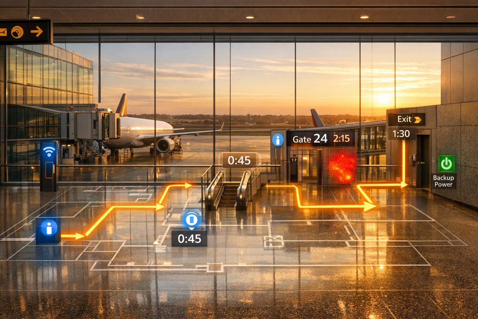
Digital twins have revolutionized evacuation planning by enabling precise simulations that use real-time data to determine the best possible evacuation routes. By analyzing factors like smoke density, heat levels, and crowd congestion, these virtual models help streamline emergency responses.
Take the FEDT system implemented in a Chinese airport waiting hall as an example. This system reduced total evacuation time by 27.75% and ensured that the time difference between exits was no more than 16.03 seconds. It achieves this through "path equivalent length" calculations, which factor in heat, visibility issues, and crowd density. Additionally, queueing theory models (M/G/C/C/FCFS) are used to manage movement through chokepoints, preventing bottlenecks. With these capabilities, airports can test and refine evacuation strategies without disrupting daily operations, improving both emergency preparedness and passenger safety.
Equipment Failure and Infrastructure Risks
Digital twins are also instrumental in identifying equipment vulnerabilities before they escalate into serious issues. By connecting IoT sensors to critical systems - like baggage handlers, jet bridges, HVAC units, and power backups - these platforms continuously monitor performance and flag potential problems early.
"A digital twin allows airport operators to visualize, analyze, and improve airport operations in real time. From passenger flow and baggage handling to cargo movement, safety planning, and sustainability, digital twins are becoming a key part of modern airport management." - CEBS Worldwide
Beyond monitoring, digital twins simulate "what-if" scenarios to evaluate the impact of potential failures. For example, they can model baggage system breakdowns during peak travel hours to assess how flight schedules would be affected. They can also simulate structural damage from earthquakes to determine how evacuation routes might need to change. By using metrics like the Common Vulnerability Scoring System (CVSS), these systems rank vulnerabilities, helping operators prioritize fixes. This proactive approach not only strengthens infrastructure but also reduces emergency response times.
Environmental and Security Hazards
Digital twins go further by simulating a wide range of threats in a controlled virtual environment. For instance, fire modeling combines BIM structural data with Fire Dynamic Simulation (FDS) to create 3D visualizations of how smoke and heat spread through terminals. Security simulations analyze crowd flow at checkpoints to identify bottlenecks and improve staffing layouts. Meanwhile, weather models predict how storms might damage infrastructure and guide decisions on gate reallocation.
These systems also address cyber-physical risks. For example, they can model scenarios where attackers compromise fueling equipment, ground vehicles, or digital displays to evaluate the secondary effects on evacuation safety and operations. Modern aircraft monitoring, which tracks up to 300,000 parameters per flight, feeds critical data into digital twins to enhance the accuracy of these scenarios.
Even in emergencies where cloud connectivity is disrupted, edge computing ensures these simulations remain operational. Tools like AWS Panorama run machine learning models locally, enabling continuous monitoring and decision-making. By preparing for complex disaster scenarios, digital twins help airports significantly improve their emergency response capabilities.
Using Anvil Labs for Airport Digital Twins
Features for Disaster Planning
Anvil Labs provides a platform that integrates various datasets - like 3D models, LiDAR scans, 360° photos, thermal imagery, and orthomosaics - to create airport digital twins tailored for disaster simulations. Airport operators can securely upload terminal and runway scans, using built-in annotation tools to highlight essential areas such as fuel storage, structural vulnerabilities, and emergency exits.
The platform's measurement tools are especially useful for tasks like calculating evacuation routes or defining safety zones. For example, planners can measure the distance between aircraft parking spots and terminal exits or map out safe perimeters around potential fuel spill areas. Thermal overlays help simulate fire scenarios, showing how heat and smoke might spread, while LiDAR data can quickly assess structural stability after events like earthquakes.
Cross-Device Access and Team Collaboration
Beyond precise measurements, Anvil Labs ensures critical digital twin data is accessible across multiple devices. In emergencies, teams can access real-time information on desktops, tablets, and mobile devices, enabling seamless coordination among agencies like the FAA, fire departments, airport security, and medical teams. The platform’s integrated tools for annotations and task management enhance collaboration.
For instance, a fire chief responding to a terminal incident can review evacuation plans on a tablet while command center staff work on the same model from a desktop. Teams can assign tasks directly within the platform, such as checking the functionality of emergency exits or testing backup power systems, ensuring everyone is aligned in real time.
Anvil Labs Plan Comparison
Anvil Labs offers flexible plans designed to meet the diverse needs of airports, from small-scale operations to large, complex hubs. Here’s a breakdown of the two main plans:
| Feature | Asset Viewer ($99/month) | Project Hosting ($49/project) |
|---|---|---|
| 3D Model & LiDAR Hosting | Yes | Yes |
| Annotations & Measurements | Limited | Full access |
| Team Collaboration | Yes | Yes |
| Data Processing | Optional ($3/gigapixel) | Not included |
| Storage Capacity | Limited | Project-based |
| Cross-Device Access | Yes | Yes |
The Asset Viewer plan is ideal for large airports requiring extensive hosting and real-time collaboration tools, especially for ongoing disaster simulations. On the other hand, the Project Hosting plan works well for smaller airports or organizations that want to experiment with digital twin technology on a smaller scale, such as focusing on specific terminal sections. For airports dealing with high-resolution LiDAR scans of entire campuses, the optional data processing feature in the Asset Viewer plan becomes a key advantage, making it easier to handle gigapixel-scale datasets efficiently.
Implementing Digital Twins for Airport Emergency Response
Scanning and Data Collection
To build a digital twin, start by gathering detailed spatial data with LiDAR sensors and drone-mounted cameras. These tools help create a precise 3D model of airport spaces, including terminals, runways, and other critical infrastructure. Additionally, existing CAD drawings can be converted into Building Information Modeling (BIM) formats like Revit to establish the foundational geometry.
Before adding new sensors, review historical maintenance records, Building Management System (BMS) logs, and inspection reports. This historical data is invaluable for informing the digital twin's development. Once the physical scans are complete, layer real-time telemetry from IoT sensors that monitor vibration, temperature, and pressure. Combine this with data from access control systems and operational databases to create a comprehensive resource for emergency response scenarios.
Airports that have adopted frameworks like FIWARE Open Source have seen measurable improvements, such as reduced flight delays, by leveraging real-time data to enhance task scheduling and operational insights. This rich dataset forms the backbone for integrating platforms and running disaster simulations effectively.
Platform Integration and Testing
Once the data is collected, upload it to the digital twin platform and run "what-if" disaster simulations. These simulations allow airports to test emergency scenarios in a virtual environment without interrupting daily operations. Algorithms like Dijkstra's can dynamically calculate optimized evacuation routes and allocate personnel efficiently during these tests.
Real-time cross-platform testing enhances preparedness. For example, Vancouver International Airport introduced North America's first real-time 3D digital twin in July 2023, using Unity. This system integrates LiDAR and CAD data, enabling over 600 staff members to conduct disaster simulations and evacuation drills.
"I believe that the digital twin is an absolute game changer in the business of airports and will be a key enabler to our strategy" - Lynette DuJohn, Vice President of Innovation and CIO at Vancouver Airport Authority
The platform should also integrate with the airport's Computerized Maintenance Management System (CMMS). This ensures that emergency alerts can automatically trigger work orders and assign technicians, speeding up response times. To start, focus on high-priority assets like jet bridges or baggage systems to demonstrate the system's value. Pilot projects for a single asset category typically cost between $50,000 and $200,000, depending on the complexity of sensor integration and existing infrastructure.
Continuous Updates for Resilience
Keeping the digital twin accurate in real-time is crucial, especially during emergencies. This requires continuous synchronization with IoT sensors, cameras, flight schedules, and building management systems. The process involves two key phases: capturing physical-world changes (metrology phase) and transmitting those updates to the virtual model (realization phase).
Establishing a 4–8 week baseline under normal operating conditions helps the twin identify deviations and potential risks during emergencies. Tools like Amazon CloudFormation or AWS CDK can streamline updates and perform automated security checks across the digital twin infrastructure.
Edge computing is another critical component for disaster resilience. By deploying local machine learning models using tools like AWS Panorama or Greengrass, the digital twin can continue processing data and supporting autonomous operations even if cloud connectivity is disrupted. Feeding completed maintenance work orders and incident reports back into the system improves predictive accuracy over time. As of 2026, 44% of airports are using digital twin technology, and these implementations have led to a 38% reduction in equipment downtime.
Build disaster resilient cities: Disaster response operations using digital twin
Conclusion
Digital twin technology is reshaping how airports plan for disasters and respond to emergencies. By creating virtual, real-time replicas of physical operations, airports can simulate evacuation strategies, test responses to cyberattacks, and identify potential infrastructure weaknesses - all without interfering with daily activities. Research highlights that well-designed digital twins can significantly enhance evacuation processes, allowing for faster and more effective decision-making during critical moments.
One key advantage of digital twins is their ability to integrate real-time data with local processing. This ensures that essential functions remain operational even if cloud connectivity is disrupted, providing a reliable fallback in high-stakes situations.
"A Digital Twin (DT) of an airport's full operations can play an important role in defending against cyberattacks by providing a secure virtual environment to model threats, test mitigations, and help ensure continuity of critical services." - Abraham Itzhak Weinberg, AI Experts
Platforms like Anvil Labs are at the forefront of this transformation. Their infrastructure supports tools like LiDAR point clouds, thermal imagery, and 3D models, while also enabling cross-device accessibility. This allows airports to centralize spatial data and empower teams to collaborate on disaster scenarios from any location. Anvil Labs' platform also stands out for its secure sharing features and seamless integration capabilities, ensuring emergency response teams always have access to up-to-date facility data when it matters most.
FAQs
What data is needed to create an airport disaster-planning digital twin?
Creating a digital twin for airport disaster planning relies on combining various data sources to build an accurate and functional model. Key inputs include:
- 3D spatial data: Gathered through tools like drones, LiDAR, or photogrammetry, this data maps the physical layout of the airport in fine detail.
- Real-time operational data: IoT devices provide crucial insights into passenger movement, baggage handling systems, and other ongoing operations.
- Environmental data: Weather sensors and hazardous material detectors supply information about external conditions that could impact safety.
By bringing all these elements together, the digital twin can simulate scenarios, assess potential damage, and refine emergency response strategies.
How do digital twins keep working if the internet or cloud goes down?
Digital twins can keep functioning even during internet or cloud outages by relying on locally stored data and leveraging edge computing. This setup enables real-time monitoring, running simulations, and sending alerts without needing constant cloud connectivity. As a result, they can maintain critical operations in situations where connectivity is disrupted.
How fast can an airport deploy a usable digital twin for evacuations and emergencies?
Airports can set up a working digital twin for handling evacuations and emergencies within days or weeks. The exact timeframe depends on factors like the complexity of the airport and the level of data integration required. For instance, San Francisco International Airport has implemented real-time operational mapping to improve its processes. These digital models offer precise, real-time visualizations of airport activities, boosting both preparedness and response capabilities.
